METAR & TAF KBCB
Current METAR
Observed 18:35Z
KBCB 261835Z AUTO 24003KT 10SM SCT030 BKN060 27/20 A3002 RMK AO2 T02690204
- Wind
- 240° @ 3 kt
- Visibility
- 10 SM
- Temp / Dew
- 27°C / 20°C
- Altimeter
- 30.02 inHg
- Clouds
- BKN
- Density alt
- 3,944 ft
- Ceiling
- 6,000 ft AGL
- Rules
- VFR
Airport info & contacts
Manager on record, flight service, ARTCC, attendance schedule and pattern altitude — published by the FAA and refreshed every 28 days.
Location
- From city
- 3 NM S
- VFR sectional
- CINCINNATI
- ARTCC
- ZDC · WASHINGTON
- NOTAM facility
- BCB (NOTAM-D)
Airport manager
- Name
- KEITH HOLT
- Phone
- 540-231-4444
- Address
- 1601 RESEARCH CENTER DRIVE, BLACKSBURG VA 24060
Flight service · Hours
- FSS DCA
- LEESBURG1-800-WX-BRIEF
- Attendance
- 0800-1900
Frequencies
Tap any row to copy the frequency to your clipboard.
Runways & pattern
Full pagePattern entry · RWY 31
LEFT TRAFFICRunway end performance
| End | TORA | TODA | ASDA | LDA | VGSI | Approach lights | Obstruction |
|---|---|---|---|---|---|---|---|
| 13 | — | — | — | — | PAPI 4-box left(3.44°) | ODALS | 59', tree, 1112' from thr, 363' R of cntrln, slope 15 |
| 31 | — | — | — | — | PAPI 2-box left(3°) | — | 48', tree, 1341' from thr, 395' R of cntrln, slope 23 |
Declared distances in feet. TORA = takeoff run available, TODA = takeoff distance, ASDA = accelerate-stop, LDA = landing distance.
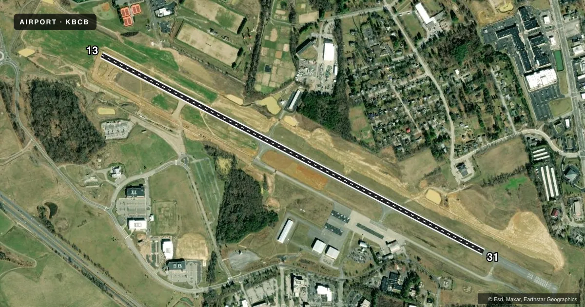
Airport sketch
Runways drawn to scale from FAA survey coordinates, rendered over satellite imagery. Not for navigation.
Approaches & charts
ILS · 1
Services on the field
Fuel grades, oxygen, maintenance, ramp storage and lighting — as declared to the FAA by the airport operator.
Fuel & services
- Fuel
- 100LLA+
- Oxygen (bottled)
- Not available
- Oxygen (bulk)
- Not available
- Airframe repair
- Not available
- Power plant repair
- Not available
- Other services
- CHTR,INSTR,RNTL
Ramp & ground
- Transient storage
- Tie-down
- Landing fee
- No fee published
- Customs
- Not available
- Lighting schedule
- SEE RMK
- Beacon schedule
- SS-SR
- Beacon
- White / Green (civil land)(WG)
- Wind indicator
- Lighted
- Segmented circle
- Yes
Fuel & FBOs
Cheapest 100LL and Jet A on the field and nearby. Always confirm with the FBO before taxi.
Airport notes
Surface conditions, obstructions, local procedures, lighting outages and other notes published with each FAA cycle.
General notes
- OCCASIONAL WILDLIFE ON ARPT.
- VFR DEPARTURES MAINTAIN RWY HEADING UNTIL REACHING 1000 FT AGL.
- NOISE SENSITIVE AREA NORTH OF ARPT.
- ROA TWR SVCS AVBL AT 540-563-1307.
- FOR CD CTC ROANOKE APCH AT 540-563-1307.
Lighting notes
- ACTVT ODALS RWY 13; REIL RWY 31; PAPI RWY 13 & 31; MIRL RWY 13/31 - CTAF. MIRL RWY 13/31 PRESET LOW INTST.
Fuel notes
- 100LLPPR FOR FUEL WHEN ARPT UNATNDD; PHONE 540-231-4444; FEE FOR AFT HRS.
Other notes
- TPA 1000 FT AGL FOR NON TURBINE POWERED ACFT. TPA FOR TURBINE POWERED ACFT 1500 FT AGL.
- 1UNATNDD NEW YEARS DAY, THANKSGIVING DAY, CHRISTMAS DAY, MAJOR HOLS.
VFR map & nearby airports
VFR sectional. Tap any ICAO chip to open that airport.
Key facts · KBCB
Answer card- ICAO
- KBCB
- Name
- VIRGINIA TECH/MONTGOMERY EXEC
- Location
- BLACKSBURG, VIRGINIA
- Elevation
- 2,119.4 ft MSL
- Traffic pattern altitude
- 3,119.4 ft MSL (1,000 AGL)
- Control tower
- Non-towered (use CTAF)
- Total runways
- 1
- Longest runway
- 13/31 · 5,501 ft
- Published ILS approaches
- 1
- Published frequencies
- 5
- Magnetic variation
- 8°
- Current flight rules
- VFR
- Current wind
- 240° at 3 kt
- Favored runway now
- RWY 31
Virginia Tech/Montgomery Exec is in Blacksburg, Virginia. Field elevation is 2,119.4 ft MSL. The airport has one runway. Runway 13/31 is 5,501 ft long with an asphalt surface. There is one ILS approach. It serves runway 13. The airport is not towered. Roanoke Approach handles clearance delivery. The published traffic pattern altitude is 1,000 ft AGL for non-turbine aircraft. Turbine aircraft use 1,500 ft AGL.
Virginia Tech Airport is the on-field FBO. It carries 100LL and Jet A Prist. Call (540) 231-4444 before you go. Fuel prior permission is required when the airport is unattended. There is also a fee for after-hours fuel. The airport is unattended on New Year's Day, Thanksgiving Day, Christmas Day and major holidays.
A few operational items matter here. There is a noise sensitive area north of the airport. Wildlife can also be present on the field. VFR departures must maintain runway heading until reaching 1,000 ft AGL. The runway lighting is pilot-controlled on CTAF, with PAPI on both ends and REIL on runway 31. For a first-time arrival, plan for the higher field elevation and watch the terrain and density altitude picture in the Blacksburg area.