METAR & TAF KLWB
Current METAR
Observed 09:55Z
KLWB 270955Z AUTO 11003KT M1/4SM FG OVC001 16/16 A2997 RMK AO2
- Wind
- 110° @ 3 kt
- Visibility
- —
- Temp / Dew
- 16°C / 16°C
- Altimeter
- 29.97 inHg
- Clouds
- OVC
- Density alt
- 2,912 ft
- Ceiling
- 100 ft AGL
- Rules
- LIFR
Airport info & contacts
Manager on record, flight service, ARTCC, attendance schedule and pattern altitude — published by the FAA and refreshed every 28 days.
Location
- From city
- 3 NM N
- VFR sectional
- CINCINNATI
- ARTCC
- ZDC · WASHINGTON
- NOTAM facility
- LWB (NOTAM-D)
Airport manager
- Name
- MARTHA LIVESAY
- Phone
- 304-646-7382
- Address
- 584 AIRPORT RD BOX 1, LEWISBURG WV 24901
Flight service · Hours
- FSS EKN
- ELKINS703-724-42881-800-WX-BRIEF
- Attendance
- ALL
Frequencies
Tap any row to copy the frequency to your clipboard.
Runways & pattern
Full pagePattern entry · RWY 04
LEFT TRAFFICRunway end performance
| End | TORA | TODA | ASDA | LDA | VGSI | Approach lights | Obstruction |
|---|---|---|---|---|---|---|---|
| 04 | 7,003' | 7,003' | 7,003' | 7,003' | — | MALSR | — |
| 22 | 7,003' | 7,003' | 7,003' | 7,003' | PAPI 4-box left(3°) | — | — |
Declared distances in feet. TORA = takeoff run available, TODA = takeoff distance, ASDA = accelerate-stop, LDA = landing distance.
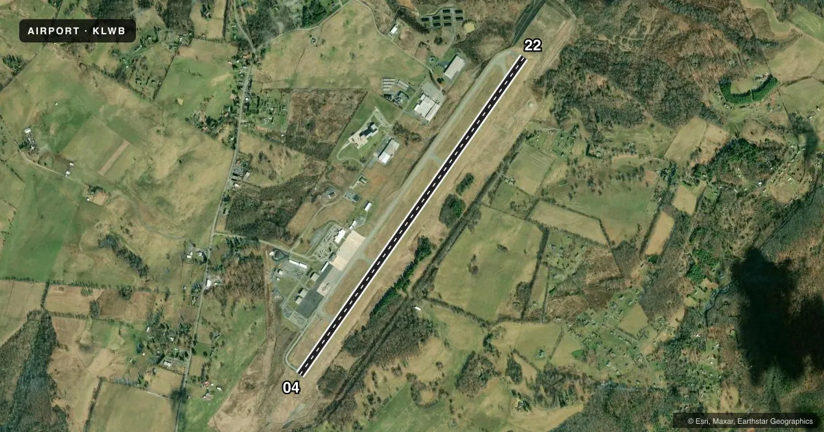
Airport sketch
Runways drawn to scale from FAA survey coordinates, rendered over satellite imagery. Not for navigation.
Approaches & charts
ILS · 1
Services on the field
Fuel grades, oxygen, maintenance, ramp storage and lighting — as declared to the FAA by the airport operator.
Fuel & services
- Fuel
- 100LLA
- Oxygen (bottled)
- Not available
- Oxygen (bulk)
- Not available
- Airframe repair
- Minor
- Power plant repair
- Minor
- Other services
- CARGO,CHTR,INSTR,RNTL,SALES
Ramp & ground
- Transient storage
- Tie-down
- Hangar
- Landing fee
- Yes
- Customs
- Not available
- Lighting schedule
- SEE RMK
- Beacon schedule
- SS-SR
- Beacon
- White / Green (civil land)(WG)
- Wind indicator
- Lighted
- Segmented circle
- Yes
Fuel & FBOs
Cheapest 100LL and Jet A on the field and nearby. Always confirm with the FBO before taxi.
Airport notes
Surface conditions, obstructions, local procedures, lighting outages and other notes published with each FAA cycle.
General notes
- BIRDS & DEER ON & INVOF ARPT.
- USE CTAF 118.9 WHEN TWR CLSD. FREQ 121.5 NOT AVBL AT TWR.
Lighting notes
- ACTVT MALSR RWY 04; REIL RWY 22; PAPI RWY 22; HIRL RWY 04/22; TWY LGTS - CTAF.
Runway surface & condition
- 04/22PCR VALUE: 360/F/D/X/T
Other notes
- PPR 24 HRS FOR UNSKED ACR OPNS WITH MORE THAN 30 PSGR SEATS CALL AMGR 304-645-3961. ARFF INDEX C EQPT AVBL UPON REQ.
- LNDG FEE FOR ALL ACFT ABV 4000 LBS. LNDG FEE WAIVED WITH APPLICIABLE FUEL PURCHASE BASED ON ACFT WEIGHT OR IF ACFT IS REGISTERED IN THE STATE OF WEST VIRGINIA OR FUEL PURCHASE WITH A U.S. GOVT AIR CARD.
- SEGMENTED CIRCLE INSTALLED AROUND NEW WINDCONE LOCATION WEST SIDE OF TAXIWAY A
- MANAGERMGR CELL: 304-646-7382
VFR map & nearby airports
VFR sectional. Tap any ICAO chip to open that airport.
Key facts · KLWB
Answer card- ICAO
- KLWB
- Name
- GREENBRIER VALLEY
- Location
- LEWISBURG, WEST VIRGINIA
- Elevation
- 2,301.6 ft MSL
- Traffic pattern altitude
- 3,301.6 ft MSL (1,000 AGL)
- Control tower
- Towered · 0900-1900
- Total runways
- 1
- Longest runway
- 04/22 · 7,003 ft
- Published ILS approaches
- 1
- Published frequencies
- 5
- Magnetic variation
- 8°
- Current flight rules
- LIFR
- Current wind
- 110° at 3 kt
- Favored runway now
- RWY 04
Greenbrier Valley Airport sits in Lewisburg, West Virginia. Field elevation is 2,301.6 ft MSL. The airport has one runway, 04/22 and it is 7,003 ft long. The tower is open daily from 0900 to 1900. One ILS approach is published for runway 04.
Pattern altitude is not published in the facts. Use the standard 1,000 ft AGL for light piston traffic unless ATC or the current Chart Supplement says otherwise. The on-field FBO is Greenbrier Valley Airport. It carries 100LL, Jet A and Jet A Prist. Call 304-645-3961 before arrival if you need current ramp or fuel details.
The lighting setup is worth planning for. MALSR serves runway 04. Runway end identifier lights are on runway 22. A PAPI is installed for runway 22. High intensity runway lights are installed on both ends. Taxiway lights are controlled by CTAF. Birds and deer are reported on and near the airport. Keep a sharp scan on arrival and departure. There is also a landing fee for aircraft above 4,000 lb unless a listed waiver applies. This field is in a mountainous part of West Virginia. Expect terrain awareness to matter on every approach and departure.