METAR & TAF 3I4
3I4 does not publish a METAR.
Showing the nearest reporting station: KLWB (GREENBRIER VALLEY) · 26.8 NM away. Conditions at 3I4 may differ.
METAR · KLWB
Observed 05:35Z
KLWB 270535Z AUTO 00000KT 6SM BR BKN055 17/17 A2999 RMK AO2
- Wind
- 000° @ 0 kt
- Visibility
- 6 SM
- Temp / Dew
- 17°C / 17°C
- Altimeter
- 29.99 inHg
- Clouds
- BKN
- Density alt
- 3,236 ft
- Ceiling
- 5,500 ft AGL
- Rules
- VFR
Airport info & contacts
Manager on record, flight service, ARTCC, attendance schedule and pattern altitude — published by the FAA and refreshed every 28 days.
Location
- From city
- 6 NM W
- VFR sectional
- CINCINNATI
- ARTCC
- ZDC · WASHINGTON
- NOTAM facility
- EKN (NOTAM-D)
Airport manager
- Name
- BOB JOHNSON
- Phone
- 304-618-3611
- Address
- RICHWOOD AIRPORT AUTHORITY, 6 WHITE AVE, RICHWOOD WV 26261
Flight service · Hours
- FSS EKN
- ELKINS703-724-42881-800-WX-BRIEF
- Attendance
- Unattended
Frequencies
Tap any row to copy the frequency to your clipboard.
Runways & pattern
Full pagePattern entry · RWY 10
LEFT TRAFFICRunway end performance
| End | TORA | TODA | ASDA | LDA | VGSI | Approach lights | Obstruction |
|---|---|---|---|---|---|---|---|
| 10 | — | — | — | — | — | — | 18', trees, 222' from thr, 60' R of cntrln, slope 1 |
| 28 | — | — | — | — | — | — | 70', trees, 275' from thr, 140' R of cntrln, slope 1 |
Declared distances in feet. TORA = takeoff run available, TODA = takeoff distance, ASDA = accelerate-stop, LDA = landing distance.
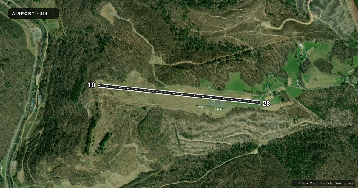
Airport sketch
Runways drawn to scale from FAA survey coordinates, rendered over satellite imagery. Not for navigation.
Approaches & charts
Services on the field
Fuel grades, oxygen, maintenance, ramp storage and lighting — as declared to the FAA by the airport operator.
Fuel & services
- Fuel
- Not available
- Oxygen (bottled)
- Not available
- Oxygen (bulk)
- Not available
Ramp & ground
- Transient storage
- Tie-down
- Landing fee
- No fee published
- Customs
- Not available
- Wind indicator
- Yes
- Segmented circle
- No
Fuel & FBOs
Cheapest 100LL and Jet A on the field and nearby. Always confirm with the FBO before taxi.
Airport notes
Surface conditions, obstructions, local procedures, lighting outages and other notes published with each FAA cycle.
General notes
- RWY 10/28 NO SNOW REMOVAL. RWY FREQUENTLY SNOW COVERED WINTER MONTHS.
- DEER & BIRDS ON & INVOF ARPT.
- ARPT CLSD NIGHTS.
- ARPT PHYS. ADDR. 3437 AIRPORT RD. RICHWOOD, WV.
- FOR CD CTC WASHINGTON ARTCC AT 703-771-3587.
- ARPT GATE LOCKED. CALL AMGR FOR ACCESS.
Approach & departure obstructions
- 1040 FT TREES, UP TO 199 FT DSTC.
- 2810 FT GND & 50 FT TREES; 30 TO 199 FT DSTC.
Other notes
- OWNERGARY JOHNSON, MAYOR 304-562-4379; GARYJONHSONMAYOR@GMAIL.COM.
- 10/28PAVEMENT CRACKS WITH VEGETATION.
- 10/28SOFT SHOULDERS.
VFR map & nearby airports
VFR sectional. Tap any ICAO chip to open that airport.
Key facts · 3I4
Answer card- ICAO
- 3I4
- Name
- RICHWOOD MUNI
- Location
- RICHWOOD, WEST VIRGINIA
- Elevation
- 2,486 ft MSL
- Traffic pattern altitude
- 3,486 ft MSL (1,000 AGL)
- Control tower
- Non-towered (use CTAF)
- Total runways
- 1
- Longest runway
- 10/28 · 3,360 ft
- Published ILS approaches
- 0
- Published frequencies
- 1
- Magnetic variation
- 6°
- Current flight rules
- VFR
- Current wind
- 000° at 0 kt
- Favored runway now
- –
Richwood Muni is in Richwood, West Virginia. The field elevation is 2,486 ft MSL. It has one runway, 10/28, which is 3,360 ft long. There is no control tower. CTAF is 122.9.
No ILS approaches are published here. The airport is closed at night. The published pattern altitude is not listed, so use the standard 1,000 ft AGL for light piston operations unless the current FAA Chart Supplement says otherwise. That puts the pattern at about 3,486 ft MSL based on the field elevation. Verify before flight.
The runway surface is asphalt. The published remarks call out cracks with vegetation, soft shoulders and no snow removal. Winter use can be a problem because the runway is frequently snow covered. There are also tree obstructions near both runway ends. Deer and birds are reported on and near the airport. The gate is locked. Call the airport manager for access before you go.
No on-field FBOs are listed in the facts. Plan on calling the airport operator or the FBO directly by phone for current services. For clearance delivery, contact Washington ARTCC at 703-771-3587. If you are planning a first visit, treat this as a high-elevation mountain field with limited services. Check the current FAA Chart Supplement before departure.