METAR & TAF 48I
Current METAR
Observed 12:55Z
K48I 271255Z AUTO 00000KT 7SM OVC004 20/20 A2996 RMK AO2 T02020201 $
- Wind
- 000° @ 0 kt
- Visibility
- 7 SM
- Temp / Dew
- 20°C / 20°C
- Altimeter
- 29.96 inHg
- Clouds
- OVC
- Density alt
- 2,132 ft
- Ceiling
- 400 ft AGL
- Rules
- LIFR
Airport info & contacts
Manager on record, flight service, ARTCC, attendance schedule and pattern altitude — published by the FAA and refreshed every 28 days.
Location
- From city
- 3 NM E
- VFR sectional
- CINCINNATI
- ARTCC
- ZOB · CLEVELAND
- NOTAM facility
- EKN (NOTAM-D)
Airport manager
- Name
- PATRICK O'MALLEY
- Phone
- (304) 542-3311
- Address
- 106 BIRCH ST, GASAWAY WV 26624-1102
Flight service · Hours
- FSS EKN
- ELKINS703-724-42881-800-WX-BRIEF
- Attendance
- Unattended
Frequencies
Tap any row to copy the frequency to your clipboard.
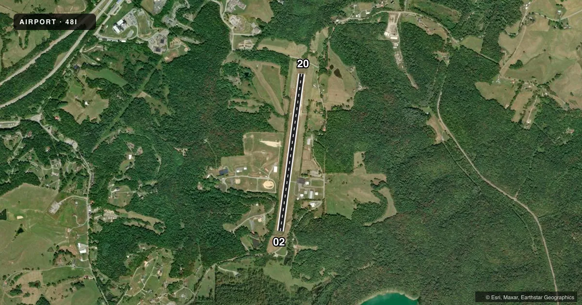
Runways & pattern
Full pagePattern entry · RWY 02
LEFT TRAFFICRunway end performance
| End | TORA | TODA | ASDA | LDA | VGSI | Approach lights | Obstruction |
|---|---|---|---|---|---|---|---|
| 02 | 3,995' | 3,995' | 3,995' | 3,194' | — | — | 85', trees, 201' from thr, 220' R of cntrln, slope 0 |
| 20 | 3,995' | 3,995' | 3,815' | 3,815' | PAPI 2-box left(4°) | — | 113', trees, 844' from thr, 370' R of cntrln, slope 5 |
Declared distances in feet. TORA = takeoff run available, TODA = takeoff distance, ASDA = accelerate-stop, LDA = landing distance.
Airport sketch
Runways drawn to scale from FAA survey coordinates, rendered over satellite imagery. Not for navigation.
Approaches & charts
Services on the field
Fuel grades, oxygen, maintenance, ramp storage and lighting — as declared to the FAA by the airport operator.
Fuel & services
- Fuel
- 100LLA
- Oxygen (bottled)
- Not available
- Oxygen (bulk)
- Not available
- Airframe repair
- Not available
- Power plant repair
- Not available
Ramp & ground
- Transient storage
- Tie-down
- Hangar
- Landing fee
- No fee published
- Customs
- Not available
- Lighting schedule
- SEE RMK
- Beacon schedule
- SEE RMK
- Beacon
- White / Green (civil land)(WG)
- Wind indicator
- Lighted
- Segmented circle
- Yes
Fuel & FBOs
Cheapest 100LL and Jet A on the field and nearby. Always confirm with the FBO before taxi.
Airport notes
Surface conditions, obstructions, local procedures, lighting outages and other notes published with each FAA cycle.
General notes
- 6 FT DITCH CROSSES AER 02 0-116 FT FROM THR.
- GATE ACCESS 1-2-3-4-#.
- FOR CD CTC CLARKSBURG APCH AT 304-842-2011. WHEN APP CLSD, CTC INDIANAPOLIS ARTCC AT 317-247-2411.
- DEER ON AND INVOF ARPT.
Lighting notes
- BCN LCTD ON HILL, 1/4 MILE NW OF ARPT.
- ACTVT BEACON - CTAF.
- ACTVT REIL RWY 02 & 20; PAPI RWY 20; MIRL RWY 02/20 - CTAF.
Approach & departure obstructions
- 0226 FT TREES, 0-199, 216 FT L.
- 2017 FT HILL, 0-199 FT DSTC, 247 FT R.
- 20UNUSBL BYD 6 DEG LEFT AND BYD 6 DEG RIGHT OF CNTRLN.
- 02APCH RATIO 0:1 TO DSPLCD THR, 80 FT TREES, 0 FT DSTC, 210 FT L. APCH RATIO 25:1 BASED ON STRAIGHT OUT OVR 53 FT TREES, 1340 FT DSTC, 0 FT B.
VFR map & nearby airports
VFR sectional. Tap any ICAO chip to open that airport.
Key facts · 48I
Answer card- ICAO
- 48I
- Name
- BRAXTON COUNTY
- Location
- SUTTON, WEST VIRGINIA
- Elevation
- 1,275.6 ft MSL
- Traffic pattern altitude
- 2,275.6 ft MSL (1,000 AGL)
- Control tower
- Non-towered (use CTAF)
- Total runways
- 1
- Longest runway
- 02/20 · 3,995 ft
- Published ILS approaches
- 0
- Published frequencies
- 3
- Magnetic variation
- 8°
- Current flight rules
- LIFR
- Current wind
- 000° at 0 kt
- Favored runway now
- –
Braxton County Airport is in Sutton, West Virginia. The field elevation is 1,275.6 ft MSL. It has one runway, 02/20, which is 3,995 ft long and asphalt. There is no control tower. No ILS approaches are published.
For pattern work, the published pattern altitude is not listed. Use the standard 1,000 ft AGL pattern for light piston operations unless the current FAA Chart Supplement says otherwise. The airport sits in a terrain and obstacle environment that deserves a close look on both ends. Runway 02 has trees near the approach end. There is also a ditch crossing the approach end. Runway 20 has a hill off the right side near the threshold. Deer are reported on and near the airport.
Braxton County Airport is served by the Braxton County Airport FBO on field. It carries AVGAS 100LL and JET A. Call ahead at (304) 853-2538 for current service details. Published remarks also note that the beacon is on a hill northwest of the airport. Runway 02 and runway 20 have medium intensity lights activated by CTAF. Runway 20 also has PAPI. For clearance delivery, contact Clarksburg Approach. If approach is closed, use Indianapolis ARTCC. This is the kind of field where a first-time arrival should brief the runway environment, lighting and local traffic before descent.