METAR & TAF KSXL
KSXL does not publish a METAR.
Showing the nearest reporting station: KBKW (RALEIGH COUNTY MEML) · 29.2 NM away. Conditions at KSXL may differ.
METAR · KBKW
Observed 15:42Z
KBKW 261542Z AUTO 00000KT 10SM FEW019 SCT028 OVC034 25/17 A3005 RMK AO1 T02500172 $
- Wind
- 000° @ 0 kt
- Visibility
- 10 SM
- Temp / Dew
- 25°C / 17°C
- Altimeter
- 30.05 inHg
- Clouds
- OVC
- Density alt
- 3,295 ft
- Ceiling
- 3,400 ft AGL
- Rules
- VFR
Airport info & contacts
Manager on record, flight service, ARTCC, attendance schedule and pattern altitude — published by the FAA and refreshed every 28 days.
Location
- From city
- 3 NM S
- VFR sectional
- CINCINNATI
- ARTCC
- ZID · INDIANAPOLIS
- NOTAM facility
- EKN (NOTAM-D)
Airport manager
- Name
- TIM ADKINS
- Phone
- 304-881-1600
- Address
- ATTN: NCAA, PO BOX 95, SUMMERSVILLE WV 26651-0754
Flight service · Hours
- FSS EKN
- ELKINS703-724-42881-800-WX-BRIEF
- Attendance
- MON-FRI · 0800-1700
Frequencies
Tap any row to copy the frequency to your clipboard.
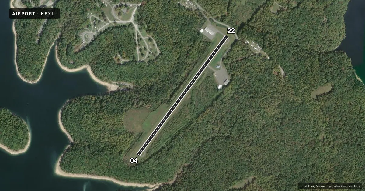
Runways & pattern
Full pagePattern entry · RWY 04
LEFT TRAFFICRunway end performance
| End | TORA | TODA | ASDA | LDA | VGSI | Approach lights | Obstruction |
|---|---|---|---|---|---|---|---|
| 04 | — | — | — | — | — | — | 50', trees, 201' from thr, 150' R of cntrln, slope 0 |
| 22 | — | — | — | — | PAPI 2-box left(3.25°) | — | 65', trees, 201' from thr, 150' R of cntrln, slope 0 |
Declared distances in feet. TORA = takeoff run available, TODA = takeoff distance, ASDA = accelerate-stop, LDA = landing distance.
Airport sketch
Runways drawn to scale from FAA survey coordinates, rendered over satellite imagery. Not for navigation.
Approaches & charts
Services on the field
Fuel grades, oxygen, maintenance, ramp storage and lighting — as declared to the FAA by the airport operator.
Fuel & services
- Fuel
- 100LL
- Oxygen (bottled)
- Not available
- Oxygen (bulk)
- Not available
- Airframe repair
- Not available
- Power plant repair
- Not available
Ramp & ground
- Transient storage
- Tie-down
- Landing fee
- No fee published
- Customs
- Not available
- Lighting schedule
- SEE RMK
- Beacon schedule
- SEE RMK
- Beacon
- White / Green (civil land)(WG)
- Wind indicator
- Lighted
- Segmented circle
- No
Fuel & FBOs
Cheapest 100LL and Jet A on the field and nearby. Always confirm with the FBO before taxi.
Airport notes
Surface conditions, obstructions, local procedures, lighting outages and other notes published with each FAA cycle.
General notes
- RWY 04 50 FT DROP-OFF 110 FT FM THR.
- RWY 22 30 FT DROP-OFF 110 FT FM THR.
- FOR CD CTC CHARLESTON APCH AT 304-344-5867 EXT 281.
Lighting notes
- LIGHTHOUSE 2 MI SE. MAY BE MISTAKEN FOR RTG BCN.
- ACTVT MIRL RWY 04/22 - CTAF. PAPI RWY 22 OTS INDFLY.
Fuel notes
- 100LLSELF-SERVE.
Approach & departure obstructions
- 0430 FT TREES; UP TO 120 FT DSTC, APPROX 105 TO 125 FT RIGHT.
- 2270 FT TREES, 0 FT DSTC 200 FT L.
- 04REILS OTS INDEFLY.
- 22REILS OTS INDEFLY.
Other notes
- THIS AIRPORT HAS BEEN SURVEYED BY THE NATIONAL GEODETIC SURVEY.
- MANAGERARPT PHYS ADDR. 2506 AIRPORT RD. SUMMERSVILLE, WV 26651.
- OWNERARPT LEASED TO NICHOLAS CO. ARPT AUTH. P O BOX 95, SUMMERSVILLE, WV 26651. 304-872-7830. USACE POC TRAVIS BOWMAN. 304-590-9353 CELL PH.
VFR map & nearby airports
VFR sectional. Tap any ICAO chip to open that airport.
Key facts · KSXL
Answer card- ICAO
- KSXL
- Name
- SUMMERSVILLE
- Location
- SUMMERSVILLE, WEST VIRGINIA
- Elevation
- 1,819.7 ft MSL
- Traffic pattern altitude
- 2,819.7 ft MSL (1,000 AGL)
- Control tower
- Non-towered (use CTAF)
- Total runways
- 1
- Longest runway
- 04/22 · 3,015 ft
- Published ILS approaches
- 0
- Published frequencies
- 4
- Magnetic variation
- 7°
- Current flight rules
- VFR
- Current wind
- 000° at 0 kt
- Favored runway now
- –
Summersville Airport sits in Summersville, West Virginia. Field elevation is 1,819.7 ft MSL. The airport has one runway. Runway 04/22 is 3,015 ft asphalt, so plan performance with the field elevation in mind. There is no control tower. CTAF and UNICOM are both 122.8. For clearance delivery, Charleston Approach can be reached at 304-344-5867 extension 281.
No ILS approaches are published here. Pattern altitude is not published, so use the standard 1,000 ft AGL for light piston operations unless the current Chart Supplement says otherwise. The on-field FBO is Summersville Airport. It carries 100LL and Jet A Prist. 100LL is self-serve. Published remarks also note that runway lights on 04/22 are activated by CTAF. Runway end identifier lights are out of service on both ends. The PAPI on runway 22 is also out of service.
This is a field where you want to brief the runway environment before arrival. There are 30 ft trees near the right side of runway 04. Runway 04 also has a 50 ft drop-off near the threshold. Runway 22 has a 30 ft drop-off near the threshold and 70 ft trees left of the runway near the approach end. A lighthouse 2 miles southeast may be mistaken for the rotating beacon. Check the current Chart Supplement for any updated remarks before you go.