METAR & TAF 55I
55I does not publish a METAR.
Showing the nearest reporting station: KCRW (WEST VIRGINIA INTL YEAGER) · 27.5 NM away. Conditions at 55I may differ.
METAR · KCRW
Observed 13:15Z
KCRW 271315Z 00000KT 1/4SM FG VV002 21/21 A2995 RMK AO2 PWR OK T02110211 $
- Wind
- 000° @ 0 kt
- Visibility
- 0.25 SM
- Temp / Dew
- 21°C / 21°C
- Altimeter
- 29.95 inHg
- Clouds
- VV
- Density alt
- 1,924 ft
- Ceiling
- 200 ft AGL
- Rules
- LIFR
Airport info & contacts
Manager on record, flight service, ARTCC, attendance schedule and pattern altitude — published by the FAA and refreshed every 28 days.
Location
- From city
- 3 NM SE
- VFR sectional
- CINCINNATI
- ARTCC
- ZID · INDIANAPOLIS
- NOTAM facility
- EKN (NOTAM-D)
Airport manager
- Name
- GARY E HARPER
- Phone
- 304-545-8154
- Address
- 114 CUNNINGHAM LANE, WALTON WV 25286
Flight service · Hours
- FSS EKN
- ELKINS703-724-42881-800-WX-BRIEF
- Attendance
- Unattended
Frequencies
Tap any row to copy the frequency to your clipboard.
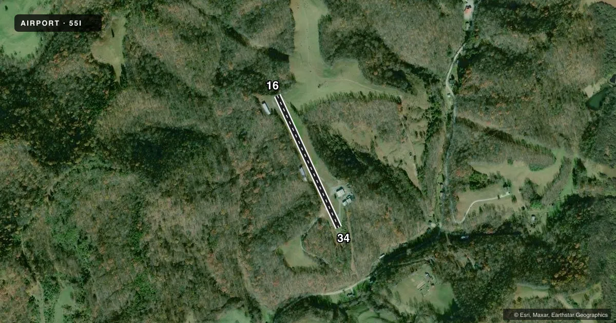
Runways & pattern
Full pagePattern entry · RWY 16
LEFT TRAFFICRunway end performance
| End | TORA | TODA | ASDA | LDA | VGSI | Approach lights | Obstruction |
|---|---|---|---|---|---|---|---|
| 16 | — | — | — | — | — | — | 75', trees, 201' from thr, 60' R of cntrln, slope 0 |
| 34 | — | — | — | — | — | — | 15', trees, 330' from thr, 44' R of cntrln, slope 8 |
Declared distances in feet. TORA = takeoff run available, TODA = takeoff distance, ASDA = accelerate-stop, LDA = landing distance.
Airport sketch
Runways drawn to scale from FAA survey coordinates, rendered over satellite imagery. Not for navigation.
Approaches & charts
Services on the field
Fuel grades, oxygen, maintenance, ramp storage and lighting — as declared to the FAA by the airport operator.
Fuel & services
- Fuel
- Not available
Ramp & ground
- Transient storage
- Not published
- Landing fee
- No fee published
- Lighting schedule
- SEE RMK
- Wind indicator
- Yes
- Segmented circle
- No
Fuel & FBOs
Cheapest 100LL and Jet A on the field and nearby. Always confirm with the FBO before taxi.
Airport notes
Surface conditions, obstructions, local procedures, lighting outages and other notes published with each FAA cycle.
General notes
- MARKED ELEC TRANSMISSION LINE ACRS APCH TO RWY 16.
- DEER ON & INVOF ARPT.
- RWY 16/24 TREES & BRUSH 40 FT FM CNTRLN.
- 100 FT DROP-OFF AT EACH RWY END.
- FOR CD CTC CHARLESTON APCH AT 304-344-5867 EXT 281.
Lighting notes
- LIRL RWY 16/34 ON REQ.
Runway surface & condition
- 16/34RWY 16/34 NSTD LIRL; 34 THR LGTS NOT CNTRD; EDGE LGTS 25 FT FM PVMNT EDGE, NSTD COLORS.
Approach & departure obstructions
- 1675 FT TREES 0-200 FT DSTC, 40 FT L.
- 3420 FT TREES, 0-100 FT DSTC, 100 FT R/L.
- 16NMRS TREES IN THE APCH.
Other notes
- COMPATIBLE TFC PATTERNS WHEN ROANE COUNTY ARPT CONSTD.
- OWNERJON HILDRETH, PRES.
VFR map & nearby airports
VFR sectional. Tap any ICAO chip to open that airport.
Key facts · 55I
Answer card- ICAO
- 55I
- Name
- SLATE RUN
- Location
- SPENCER, WEST VIRGINIA
- Elevation
- 1,001 ft MSL
- Traffic pattern altitude
- 2,001 ft MSL (1,000 AGL)
- Control tower
- Non-towered (use CTAF)
- Total runways
- 1
- Longest runway
- 16/34 · 1,730 ft
- Published ILS approaches
- 0
- Published frequencies
- 2
- Magnetic variation
- 6°
- Current flight rules
- LIFR
- Current wind
- 000° at 0 kt
- Favored runway now
- –
Slate Run is in Spencer, West Virginia. The field elevation is 1,001 ft MSL. It has one runway, 16/34, which is 1,730 ft long and asphalt. There is no control tower. CTAF and UNICOM are both 122.725. No ILS approaches are published here.
The pattern altitude is not published. Use 1,000 ft AGL for light piston traffic unless the current Chart Supplement says otherwise. The airport sits in a setting where obstacles matter. Published remarks call out trees near both runway ends. They also note a marked electric transmission line on the approach to runway 16. Deer are reported on and near the airport. There is a 100 ft drop-off at each runway end. Runway 16/34 has nonstandard low intensity lighting. The lights are available on request. The threshold lights for runway 34 are not centered. The runway edge lights are set 25 ft from the pavement edge and have nonstandard colors.
There are no on-field FBOs listed. For current fuel or service options, contact the airport operator or the field directly by phone before arrival. If you need clearance delivery, the published contact is Charleston Approach at 304-344-5867 ext. 281. This is a short runway with terrain and obstacle considerations. Plan your performance carefully before you go.