METAR & TAF KBKW
Current METAR
Observed 10:37Z
KBKW 271037Z AUTO 00000KT M1/4SM FG VV001 19/17 A3000 RMK AO1 T01890172 $
- Wind
- 000° @ 0 kt
- Visibility
- —
- Temp / Dew
- 19°C / 17°C
- Altimeter
- 30.00 inHg
- Clouds
- VV
- Density alt
- 3,486 ft
- Ceiling
- 100 ft AGL
- Rules
- LIFR
Airport info & contacts
Manager on record, flight service, ARTCC, attendance schedule and pattern altitude — published by the FAA and refreshed every 28 days.
Location
- From city
- 3 NM E
- VFR sectional
- CINCINNATI
- ARTCC
- ZID · INDIANAPOLIS
- NOTAM facility
- BKW (NOTAM-D)
Airport manager
- Name
- BOB RUNION
- Phone
- 304-255-0476
- Address
- 176 AIRPORT CIRCLE RM 105, BEAVER WV 25813
Flight service · Hours
- FSS EKN
- ELKINS703-724-42881-800-WX-BRIEF
- Attendance
- ALL
Frequencies
Tap any row to copy the frequency to your clipboard.
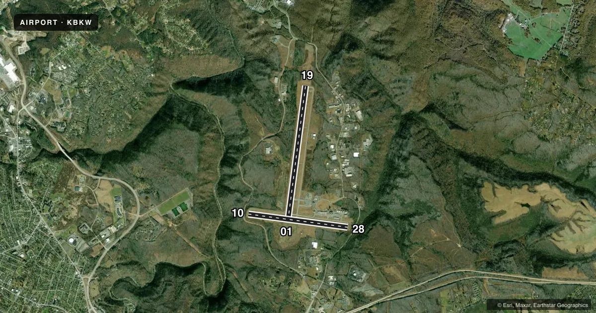
Runways & pattern
Full pagePattern entry · RWY 01
LEFT TRAFFIC| Runway | Heading (°M) | Length | Surface | Traffic |
|---|---|---|---|---|
| 01/19 | 1° / 181° | 6,750 ft | ASPH | Standard L |
| 10/28 | 92° / 272° | 5,001 ft | ASPH | Standard L |
Runway end performance
| End | TORA | TODA | ASDA | LDA | VGSI | Approach lights | Obstruction |
|---|---|---|---|---|---|---|---|
| 01 | 6,750' | 6,750' | 6,750' | 6,750' | PAPI 4-box left(3°) | — | — |
| 19 | 6,750' | 6,750' | 6,750' | 6,750' | PAPI 4-box left(3°) | MALSR | — |
| 10 | 5,001' | 5,001' | 5,001' | 5,001' | VASI 4-box right(3°) | — | — |
| 28 | 5,001' | 5,001' | 5,001' | 5,001' | VASI 4-box left(3.75°) | — | — |
Declared distances in feet. TORA = takeoff run available, TODA = takeoff distance, ASDA = accelerate-stop, LDA = landing distance.
Airport sketch
Runways drawn to scale from FAA survey coordinates, rendered over satellite imagery. Not for navigation.
Approaches & charts
ILS · 1
Services on the field
Fuel grades, oxygen, maintenance, ramp storage and lighting — as declared to the FAA by the airport operator.
Fuel & services
- Fuel
- 100LLA
- Oxygen (bottled)
- Not available
- Oxygen (bulk)
- Not available
- Airframe repair
- Major
- Power plant repair
- Major
- Other services
- AMB,CARGO,CHTR,INSTR,RNTL
Ramp & ground
- Transient storage
- Tie-down
- Hangar
- Landing fee
- No fee published
- Customs
- Not available
- Lighting schedule
- SEE RMK
- Beacon schedule
- SS-SR
- Beacon
- White / Green (civil land)(WG)
- Wind indicator
- Lighted
- Segmented circle
- No
Fuel & FBOs
Cheapest 100LL and Jet A on the field and nearby. Always confirm with the FBO before taxi.
Airport notes
Surface conditions, obstructions, local procedures, lighting outages and other notes published with each FAA cycle.
General notes
- DEER; BIRDS & WILD TURKEYS ON & INVOF ARPT.
- ALL SFCS WORK IN PROG, GRASS CUTTING APR THRU OCT.
Lighting notes
- ACTVT MALSR RWY 19; REIL RWY 01, 10 & 28; VASI RWY 10 & 28; MIRL RWY 10/28; HIRL RWY 01/19; TWY LGTS - CTAF. PAPI RWY 01 & 19 SET AT MEDIUM, CTC UNICOM TO CHANGE INTST.
Runway surface & condition
- 01/19PCR VALUE: 740/F/B/X/T
- 10/28PCR VALUE: 160/F/B/X/T
Approach & departure obstructions
- 289 FT OBSTN LGTD POLE, 125 FT FM AER, 250 FT R.
Other notes
- THIS AIRPORT HAS BEEN SURVEYED BY THE NATIONAL GEODETIC SURVEY.
- ESTAB PRIOR TO 1959.
- PPR 24 HRS FOR UNSKED ACR OPNS WITH MORE THAN 30 PSGR SEATS; CALL AMGR 304-255-0476. INDEX B COVERAGE IS PRVDD.
VFR map & nearby airports
VFR sectional. Tap any ICAO chip to open that airport.
Key facts · KBKW
Answer card- ICAO
- KBKW
- Name
- RALEIGH COUNTY MEML
- Location
- BECKLEY, WEST VIRGINIA
- Elevation
- 2,503.8 ft MSL
- Traffic pattern altitude
- 3,503.8 ft MSL (1,000 AGL)
- Control tower
- Non-towered (use CTAF)
- Total runways
- 2
- Longest runway
- 01/19 · 6,750 ft
- Published ILS approaches
- 1
- Published frequencies
- 4
- Magnetic variation
- 6°
- Current flight rules
- LIFR
- Current wind
- 000° at 0 kt
- Favored runway now
- –
Raleigh County Memorial Airport sits in Beckley, West Virginia. The field elevation is 2,503.8 ft MSL. It has two asphalt runways. Runway 01/19 is the longest at 6,750 ft. Runway 10/28 is 5,001 ft. There is no control tower, so expect non-towered traffic flow on CTAF 123.0 or UNICOM 123.0.
The airport has one ILS approach to runway 19. Pattern altitude is not published in the facts. Use the standard 1,000 ft AGL for light piston operations unless the current Chart Supplement says otherwise. The on-field FBO is Raleigh County Memorial Airport. It carries 100LL and Jet A. Call (304) 255-0476 before you go if you need current ramp or service details.
This is a higher-elevation field, so performance planning matters. The published remarks also note deer, birds and wild turkeys on or near the airport. There is a lighted obstacle near runway 28. Runway 01/19 has high-intensity runway lights. Runway 10/28 has medium-intensity runway lights. Taxiway lights are controlled by CTAF and PAPI is available on runways 10 and 28. If you are bringing a large unscheduled flight, prior permission is required 24 hours ahead. Check with the airport manager before arrival.