METAR & TAF KPSK
Current METAR
Observed 02:35Z
KPSK 270235Z AUTO 31007KT 10SM CLR 23/18 A2998 RMK AO2 T02280180
- Wind
- 310° @ 7 kt
- Visibility
- 10 SM
- Temp / Dew
- 23°C / 18°C
- Altimeter
- 29.98 inHg
- Clouds
- CLR
- Density alt
- 3,495 ft
- Ceiling
- Unlimited
- Rules
- VFR
Airport info & contacts
Manager on record, flight service, ARTCC, attendance schedule and pattern altitude — published by the FAA and refreshed every 28 days.
Location
- From city
- 2 NM N
- VFR sectional
- CINCINNATI
- ARTCC
- ZDC · WASHINGTON
- NOTAM facility
- PSK (NOTAM-D)
Airport manager
- Name
- AARON BRUMMITT
- Phone
- 540-674-4141
- Address
- 5391 C. V. JACKSON ROAD, DUBLIN VA 24084
Flight service · Hours
- FSS DCA
- LEESBURG1-800-WX-BRIEF
- Attendance
- MON-FRI · 0800-1900
- SAT-SUN · 0900-1700
Frequencies
Tap any row to copy the frequency to your clipboard.
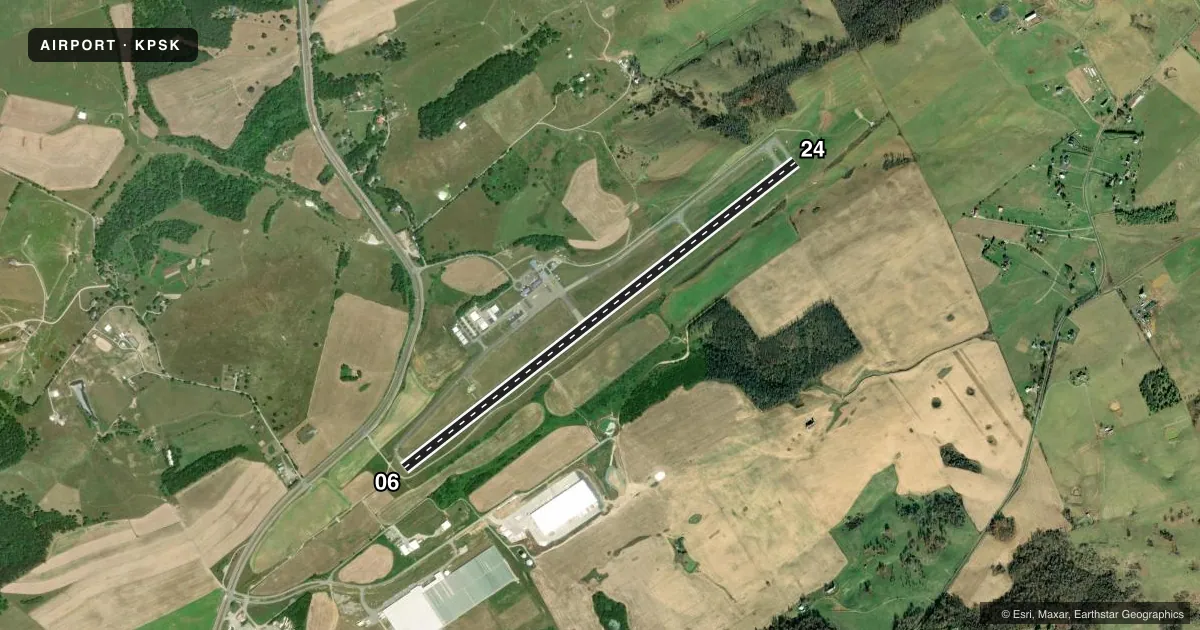
Runways & pattern
Full pagePattern entry · RWY 24
LEFT TRAFFICRunway end performance
| End | TORA | TODA | ASDA | LDA | VGSI | Approach lights | Obstruction |
|---|---|---|---|---|---|---|---|
| 06 | — | — | — | — | PAPI 4-box left(3°) | MALSR | 97', trees, 2139' from thr, 617' R of cntrln, slope 19 |
| 24 | — | — | — | — | PAPI 4-box left(3°) | — | 8', tree, 308' from thr, 23' R of cntrln, slope 13 |
Declared distances in feet. TORA = takeoff run available, TODA = takeoff distance, ASDA = accelerate-stop, LDA = landing distance.
Airport sketch
Runways drawn to scale from FAA survey coordinates, rendered over satellite imagery. Not for navigation.
Approaches & charts
ILS · 1
Services on the field
Fuel grades, oxygen, maintenance, ramp storage and lighting — as declared to the FAA by the airport operator.
Fuel & services
- Fuel
- 100LLA+
- Oxygen (bottled)
- HIGH/LOW
- Oxygen (bulk)
- Not available
- Airframe repair
- Major
- Power plant repair
- Major
- Other services
- INSTR,RNTL
Ramp & ground
- Transient storage
- Tie-down
- Hangar
- Landing fee
- No fee published
- Customs
- Not available
- Lighting schedule
- SEE RMK
- Beacon schedule
- SS-SR
- Beacon
- White / Green (civil land)(WG)
- Wind indicator
- Lighted
- Segmented circle
- Yes
Fuel & FBOs
Cheapest 100LL and Jet A on the field and nearby. Always confirm with the FBO before taxi.
Airport notes
Surface conditions, obstructions, local procedures, lighting outages and other notes published with each FAA cycle.
General notes
- DEER ON & INVOF ARPT.
- MIL CONTRACT FUEL UNAVBL.
- ROA TWR SVCS AVBL AT 540-563-1307.
Lighting notes
- ACTVT MALSR RWY 06; REIL RWY 24; PAPI RWY 06 & 24; HIRL RWY 06/24 - CTAF.
Approach & departure obstructions
- 0610 FT ROAD 100 FT FM THR ON CNTRLN (SVC ROAD).
- 0655 FT POLE 600 FT FM THR, 546 FT LEFT, MKD/LGTD. 76 FT TREES 2200 - 2450 FT FM THR, 472 - 630 FT RIGHT.
Other notes
- 2UNATNDD NEW YEARS DAY, EASTER, MEMORIAL DAY, JULY 4TH, LABOR DAY, THANKSGIVING, CHRISTMAS EVE, AND CHRISTMAS DAY.
VFR map & nearby airports
VFR sectional. Tap any ICAO chip to open that airport.
Key facts · KPSK
Answer card- ICAO
- KPSK
- Name
- NEW RIVER VALLEY
- Location
- DUBLIN, VIRGINIA
- Elevation
- 2,104.5 ft MSL
- Traffic pattern altitude
- 3,104.5 ft MSL (1,000 AGL)
- Control tower
- Non-towered (use CTAF)
- Total runways
- 1
- Longest runway
- 06/24 · 6,201 ft
- Published ILS approaches
- 1
- Published frequencies
- 5
- Magnetic variation
- 6°
- Current flight rules
- VFR
- Current wind
- 310° at 7 kt
- Favored runway now
- RWY 24
New River Valley Airport is in Dublin, Virginia. The field elevation is 2,104.5 ft MSL. It has one runway, 06/24, which is 6,201 ft long. There is no control tower. Pattern altitude is not published, so verify the current Chart Supplement before you fly the pattern.
The airport has 1 ILS approach for runway 06. CTAF and UNICOM are both 122.7. The on-field FBO is New River Valley Airport. It carries 100LL and Jet A. Call (540) 674-4141 before arrival if you need current service details.
This is a mountain-valley field with a higher elevation than many airports in Virginia. Expect density altitude to matter, especially on warm days. Published remarks also call out a 55-foot pole near the runway 06 threshold. Trees are off the 06 side. Deer are on or near the airport. Runway 06 has high intensity lights, a MALSR and PAPI. Runway 24 has REIL and PAPI. The lights are controlled by CTAF. Roanoke tower services are available by phone if you need assistance. Check the current Chart Supplement for any published noise or curfew restrictions before flying into the field.