METAR & TAF 6L4
Current METAR
Observed 11:15Z
K6L4 271115Z AUTO 00000KT M1/4SM FG BKN002 OVC044 20/20 A2997 RMK AO2
- Wind
- 000° @ 0 kt
- Visibility
- —
- Temp / Dew
- 20°C / 20°C
- Altimeter
- 29.97 inHg
- Clouds
- OVC
- Density alt
- 2,604 ft
- Ceiling
- 200 ft AGL
- Rules
- LIFR
Airport info & contacts
Manager on record, flight service, ARTCC, attendance schedule and pattern altitude — published by the FAA and refreshed every 28 days.
Location
- From city
- 4 NM E
- VFR sectional
- CINCINNATI
- ARTCC
- ZID · INDIANAPOLIS
- NOTAM facility
- EKN (NOTAM-D)
Airport manager
- Name
- MEGAN R JOHNSON
- Phone
- 304-752-0975
- Address
- P O BOX 1793, LOGAN WV 25601
Flight service · Hours
- FSS EKN
- ELKINS703-724-42881-800-WX-BRIEF
- Attendance
- 0900-1700
Frequencies
Tap any row to copy the frequency to your clipboard.
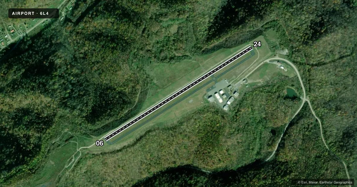
Runways & pattern
Full pagePattern entry · RWY 06
LEFT TRAFFICRunway end performance
| End | TORA | TODA | ASDA | LDA | VGSI | Approach lights | Obstruction |
|---|---|---|---|---|---|---|---|
| 06 | — | — | — | — | PAPI 2-box left(3°) | — | 77', trees, 1000' from thr, 97' R of cntrln, slope 10 |
| 24 | — | — | — | — | PAPI 2-box left(3°) | — | 10', trees, 337' from thr, 337' R of cntrln, slope 13 |
Declared distances in feet. TORA = takeoff run available, TODA = takeoff distance, ASDA = accelerate-stop, LDA = landing distance.
Airport sketch
Runways drawn to scale from FAA survey coordinates, rendered over satellite imagery. Not for navigation.
Approaches & charts
Services on the field
Fuel grades, oxygen, maintenance, ramp storage and lighting — as declared to the FAA by the airport operator.
Fuel & services
- Fuel
- 100LLA
- Airframe repair
- Major
- Power plant repair
- Major
- Other services
- AMB,AVNCS,INSTR
Ramp & ground
- Transient storage
- Tie-down
- Hangar
- Lighting schedule
- SEE RMK
- Beacon schedule
- SS-SR
- Beacon
- White / Green (civil land)(WG)
- Wind indicator
- Lighted
- Segmented circle
- Yes
Fuel & FBOs
Cheapest 100LL and Jet A on the field and nearby. Always confirm with the FBO before taxi.
Airport notes
Surface conditions, obstructions, local procedures, lighting outages and other notes published with each FAA cycle.
General notes
- RWY 06, 30 FT HILL 800 FT FROM THLD LEFT.
- DEER AND WILDLIFE ON & INVOF ARPT.
- AIRPORT ACCESS CODE- CTAF.
- FOR CD CTC CHARLESTON APCH AT 304-344-5867 EXT 281.
- MILITARY PRACTICE RWY 1.2 MILES NE OF RWY 24 END. NOT CHARTED.
- LOW LVL C-130 MIL OPNS IN VCNTY. CK NOTAMS.
Lighting notes
- ACTVT REIL RWY 06 & 24; PAPI RWY 06 & 24; MIRL RWY 06/24 - CTAF.
Fuel notes
- 100LL24 HR SELF-SVC.
Other notes
- FOR ACFT MAINT SVCS CALL 304-752-0094 DAYS, 304-946-4415 NIGHTS.
- CNTR FLD WS NOT VER, WND INDC UNRELBL. ADNL WS AT RWY 6 & 24 ENDS UNLGTD.
VFR map & nearby airports
VFR sectional. Tap any ICAO chip to open that airport.
Key facts · 6L4
Answer card- ICAO
- 6L4
- Name
- LOGAN COUNTY
- Location
- LOGAN, WEST VIRGINIA
- Elevation
- 1,666.4 ft MSL
- Traffic pattern altitude
- 2,666.4 ft MSL (1,000 AGL)
- Control tower
- Non-towered (use CTAF)
- Total runways
- 1
- Longest runway
- 06/24 · 3,605 ft
- Published ILS approaches
- 0
- Published frequencies
- 3
- Magnetic variation
- 7°
- Current flight rules
- LIFR
- Current wind
- 000° at 0 kt
- Favored runway now
- –
Logan County Airport sits in Logan, West Virginia. The field elevation is 1,666.4 ft MSL. It has one runway. Runway 06/24 is 3,605 ft long with asphalt pavement. There is no control tower. Pattern altitude is not published, so use the standard 1,000 ft AGL for light piston traffic unless ATC or local procedures say otherwise.
No ILS approaches are published here. The airport does have REIL and PAPI on runway 06 and runway 24. Medium intensity runway lighting is controlled by CTAF. 100LL is available 24 hours by self-service. Logan County Airport is the on-field FBO. It carries AVGAS 100LL and Jet A. Call (304) 752-0975 for current service details.
This is a field where local awareness matters. Low-level C-130 military activity can happen nearby. Check NOTAMs before departure. There is a 30-foot hill about 800 feet from the runway 06 threshold on the left side. Deer and other wildlife are also present on and near the airport. The wind sock situation is not fully reliable, so confirm winds with all available cues. For clearance delivery, contact Charleston Approach at 304-344-5867 extension 281. Airport access code is available on CTAF.