METAR & TAF W91
W91 does not publish a METAR.
Showing the nearest reporting station: KROA (ROANOKE/BLACKSBURG RGNL (WOODRUM FLD)) · 22.5 NM away. Conditions at W91 may differ.
METAR · KROA
Observed 03:54Z
KROA 270354Z 12004KT 10SM FEW080 23/20 A2994 RMK AO2 SLP127 T02280200 $
- Wind
- 120° @ 4 kt
- Visibility
- 10 SM
- Temp / Dew
- 23°C / 20°C
- Altimeter
- 29.94 inHg
- Clouds
- FEW
- Density alt
- 2,042 ft
- Ceiling
- Unlimited
- Rules
- VFR
Airport info & contacts
Manager on record, flight service, ARTCC, attendance schedule and pattern altitude — published by the FAA and refreshed every 28 days.
Location
- From city
- 4 NM SE
- VFR sectional
- CINCINNATI
- ARTCC
- ZDC · WASHINGTON
- NOTAM facility
- DCA (NOTAM-D)
Airport manager
- Name
- MOE BAZAZAN
- Phone
- 540-296-4950
- Address
- 1090 CUTLASS RD, MONETA VA 24121
Flight service · Hours
- FSS DCA
- LEESBURG1-800-WX-BRIEF
- Attendance
- ALL
Frequencies
Tap any row to copy the frequency to your clipboard.
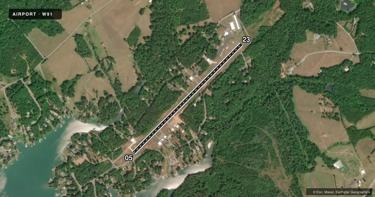
Runways & pattern
Full pagePattern entry · RWY 05
LEFT TRAFFICRunway end performance
| End | TORA | TODA | ASDA | LDA | VGSI | Approach lights | Obstruction |
|---|---|---|---|---|---|---|---|
| 05 | — | — | — | — | — | — | 43', trees, 290' from thr, 127' R of cntrln, slope 2 |
| 23 | — | — | — | — | — | — | 23', tree, 238' from thr, 122' R of cntrln, slope 1 |
Declared distances in feet. TORA = takeoff run available, TODA = takeoff distance, ASDA = accelerate-stop, LDA = landing distance.
Airport sketch
Runways drawn to scale from FAA survey coordinates, rendered over satellite imagery. Not for navigation.
Approaches & charts
Services on the field
Fuel grades, oxygen, maintenance, ramp storage and lighting — as declared to the FAA by the airport operator.
Fuel & services
- Fuel
- 100LL
- Oxygen (bottled)
- Not available
- Oxygen (bulk)
- Not available
- Airframe repair
- Major
- Power plant repair
- Major
- Other services
- INSTR,RNTL,SALES
Ramp & ground
- Transient storage
- Tie-down
- Landing fee
- Yes
- Customs
- Not available
- Lighting schedule
- SEE RMK
- Beacon schedule
- SS-SR
- Beacon
- White / Green (civil land)(WG)
- Wind indicator
- Yes
- Segmented circle
- No
Fuel & FBOs
Cheapest 100LL and Jet A on the field and nearby. Always confirm with the FBO before taxi.
Airport notes
Surface conditions, obstructions, local procedures, lighting outages and other notes published with each FAA cycle.
General notes
- ROA TWR SVCS AVBL AT 540-563-1307.
- RWY 05/23 CLSD TO LNDG ACFT MORE THAN 10000 LBS PUBLD MAX GWT.
- DEER ON & INVOF ARPT.
- APN MAIN RAMP CLSD TO HEL OPS NEAR FUEL PUMP.
- MOWING WI SAFETY AREAS OF ALL RWYS AND TWYS APR-NOV.
- LNDG FEE FOR ALL TSNT ACFT. CTC AMGR FOR FEE SKED.
Lighting notes
- ACTVT MIRL RWY 05/23 - CTAF. PAUSE 1 SECOND BETWEEN CLICKS.
Fuel notes
- 100LL24-HR SELF-SERVE FUEL AVAILABLE WITH CREDIT CARD.
Runway surface & condition
- 05/2350 YEARS OLD ASPHALT
Approach & departure obstructions
- 05RY 05 HAS +12 FT ROAD AT THLD 100 FT R. PWR POLE 128 FT RIGHT OF APCH 86 FT FM THLD.
- 05APCH SLOPE 7:1 TO DSPLCD THR BASED.
Other notes
- OVERNIGHT FEE
VFR map & nearby airports
VFR sectional. Tap any ICAO chip to open that airport.
Key facts · W91
Answer card- ICAO
- W91
- Name
- SMITH MOUNTAIN LAKE
- Location
- MONETA, VIRGINIA
- Elevation
- 892.2 ft MSL
- Traffic pattern altitude
- 1,892.2 ft MSL (1,000 AGL)
- Control tower
- Non-towered (use CTAF)
- Total runways
- 1
- Longest runway
- 05/23 · 3,058 ft
- Published ILS approaches
- 0
- Published frequencies
- 4
- Magnetic variation
- 9°
- Current flight rules
- VFR
- Current wind
- 120° at 4 kt
- Favored runway now
- RWY 05
Smith Mountain Lake Airport sits in Moneta, Virginia. Field elevation is 892.2 ft MSL. The airport has one runway. Runway 05/23 is 3,058 ft long with an asphalt surface. No tower is published here. Roanoke tower services are available by phone at 540-563-1307 if you need to coordinate traffic or ask about current conditions.
No ILS approaches are published. Pattern altitude is not published, so use the standard 1,000 ft AGL for light piston traffic unless the current Chart Supplement says otherwise. The on-field FBO is Smith Mountain Lake Airport. It carries AVGAS 100LL. Twenty-four hour self-serve 100LL is available with a credit card.
A few remarks matter for planning. The runway surface is reported as 50 years old. Deer are on and near the airport. Runway 05 has an obstruction picture that deserves attention. There is a road 12 ft high at the threshold 100 ft right of centerline. There is also a power pole 128 ft right of the approach 86 ft from the threshold. The runway lights are medium intensity and are activated on CTAF with a one second click interval. There is a landing fee for aircraft over 5,500 lb maximum gross weight plus all charter flights. There is also an overnight fee. For any local operating limits, check the current Chart Supplement before you go.