METAR & TAF W90
W90 does not publish a METAR.
Showing the nearest reporting station: KLYH (LYNCHBURG RGNL/PRESTON GLENN FLD) · 7.2 NM away. Conditions at W90 may differ.
METAR · KLYH
Observed 12:54Z
KLYH 271254Z COR 02005KT 6SM HZ FEW009 23/20 A2991 RMK AO2 T02330200
- Wind
- 020° @ 5 kt
- Visibility
- 6 SM
- Temp / Dew
- 23°C / 20°C
- Altimeter
- 29.91 inHg
- Clouds
- FEW
- Density alt
- 2,016 ft
- Ceiling
- Unlimited
- Rules
- VFR
Airport info & contacts
Manager on record, flight service, ARTCC, attendance schedule and pattern altitude — published by the FAA and refreshed every 28 days.
Location
- From city
- 6 NM SW
- VFR sectional
- CINCINNATI
- ARTCC
- ZDC · WASHINGTON
- NOTAM facility
- DCA (NOTAM-D)
Airport manager
- Name
- JOSEPH WALLACE
- Phone
- 434-582-3028
- Address
- 310 HANGAR RD, LYNCHBURG VA 24502
Flight service · Hours
- FSS DCA
- LEESBURG1-800-WX-BRIEF
- Attendance
- Unattended
Frequencies
Tap any row to copy the frequency to your clipboard.
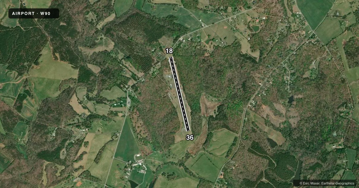
Runways & pattern
Full pagePattern entry · RWY 36
LEFT TRAFFICRunway end performance
| End | TORA | TODA | ASDA | LDA | VGSI | Approach lights | Obstruction |
|---|---|---|---|---|---|---|---|
| 18 | — | — | — | — | — | — | 16', road, 201' from thr, 10' R of cntrln, slope 0 |
| 36 | — | — | — | — | — | — | 122', trees, 2372' from thr, 58' R of cntrln, slope 17 |
Declared distances in feet. TORA = takeoff run available, TODA = takeoff distance, ASDA = accelerate-stop, LDA = landing distance.
Airport sketch
Runways drawn to scale from FAA survey coordinates, rendered over satellite imagery. Not for navigation.
Approaches & charts
Services on the field
Fuel grades, oxygen, maintenance, ramp storage and lighting — as declared to the FAA by the airport operator.
Fuel & services
- Fuel
- Not available
- Oxygen (bottled)
- Not available
- Oxygen (bulk)
- Not available
- Airframe repair
- Not available
- Power plant repair
- Not available
- Other services
- AGRI,INSTR
Ramp & ground
- Transient storage
- Tie-down
- Landing fee
- No fee published
- Customs
- Not available
- Wind indicator
- Yes
- Segmented circle
- No
Fuel & FBOs
Cheapest 100LL and Jet A on the field and nearby. Always confirm with the FBO before taxi.
Airport notes
Surface conditions, obstructions, local procedures, lighting outages and other notes published with each FAA cycle.
General notes
- STAND, FENCE & TOWER IN PRIM AND/OR TRNSL SFCS WITH GUARDRAIL BOTH SIDES OF RWY 36.
- RWY USED AS DRAG STRIP ON CERTAIN SUNDAYS SUMMER MONTHS. NOTAMED WHEN ARPT CLSD.
- ULTRA LGT ACFT ON & INVOF ARPT.
- ROA TWR SVCS AVBL AT 540-563-1307.
- FOR CD CTC ROANOKE APCH AT 540-563-1307.
Runway surface & condition
- 18/36RWY 18/36 CLSD DAILY SS-SR.
Approach & departure obstructions
- 18TREES; 110 FT LEFT OF CNTRLN. PAVED ROAD RIGHT OF CNTRLN; 125 FT FM END OF PAVEMENT.
- 36PVT ROAD USED FOR DRAG RACING LCTD AT THLD RWY 36.
- 18RWY NMRS ARE NON STD DIMENSIONS. DRAG RACING MKGS ON RWY. NO HOLD PSN MKGS VSB. THLD BAR & DSPLCMNT NON STD.
- 36RWY NMRS ARE NON STD DIMENSIONS. DRAG RACING MKGS ON RWY. NO HOLD PSN MKGS VSB.
- 18CTLNG OBSTN EXCEEDS A 45 DEG SLP.
Other notes
- PRIOR TO 1959.
- 18/36RWY PAVEMENT IN POOR COND. PCI 41-55.
VFR map & nearby airports
VFR sectional. Tap any ICAO chip to open that airport.
Key facts · W90
Answer card- ICAO
- W90
- Name
- NEW LONDON
- Location
- FOREST, VIRGINIA
- Elevation
- 842 ft MSL
- Traffic pattern altitude
- 1,842 ft MSL (1,000 AGL)
- Control tower
- Non-towered (use CTAF)
- Total runways
- 1
- Longest runway
- 18/36 · 3,164 ft
- Published ILS approaches
- 0
- Published frequencies
- 4
- Magnetic variation
- 9°
- Current flight rules
- VFR
- Current wind
- 020° at 5 kt
- Favored runway now
- RWY 36
New London Airport (W90) sits in Forest, Virginia. Field elevation is 842 ft MSL. The airport has one asphalt runway, 18/36, at 3,164 ft. No tower is on the field. Roanoke tower services are available by phone at 540-563-1307. No ILS approaches are published here. Pattern altitude is not published. Use the standard 1,000 ft AGL pattern unless the current Chart Supplement says otherwise. That puts the pattern at 1,842 ft MSL.
This field has some operational items that matter on a first visit. The runway is used as a drag strip on certain Sundays in summer. The airport is NOTAMed when closed. Runway 18/36 is closed daily from sunset to sunrise. The pavement is in poor condition, with a published PCI of 41 to 55. There are also obstructions near the runway and nonstandard runway markings. Ultralight aircraft are on and in the vicinity of the airport.
No on-field FBOs are listed. Check with the airport operator or the FBO directly by phone for current services before you go. For traffic, CTAF and UNICOM are both 122.8. If you are planning a night or low-vis arrival, verify the current status and any closure notices before departure.