METAR & TAF 0V4
Current METAR
Observed 06:35Z
K0V4 270635Z AUTO 19003KT 10SM CLR 20/20 A2987 RMK AO1
- Wind
- 190° @ 3 kt
- Visibility
- 10 SM
- Temp / Dew
- 20°C / 20°C
- Altimeter
- 29.87 inHg
- Clouds
- CLR
- Density alt
- 1,402 ft
- Ceiling
- Unlimited
- Rules
- VFR
Airport info & contacts
Manager on record, flight service, ARTCC, attendance schedule and pattern altitude — published by the FAA and refreshed every 28 days.
Location
- From city
- 6 NM NW
- VFR sectional
- CINCINNATI
- ARTCC
- ZDC · WASHINGTON
- NOTAM facility
- DCA (NOTAM-D)
Airport manager
- Name
- JERRY JENNINGS
- Phone
- 434-841-5360
- Address
- 85 CARDEN LANE, PO BOX 100, GLADYS VA 24554
Flight service · Hours
- FSS DCA
- LEESBURG1-800-WX-BRIEF
- Attendance
- Unattended
Frequencies
Tap any row to copy the frequency to your clipboard.
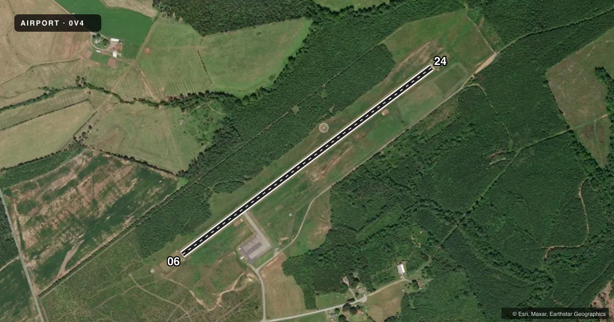
Runways & pattern
Full pagePattern entry · RWY 24
LEFT TRAFFICRunway end performance
| End | TORA | TODA | ASDA | LDA | VGSI | Approach lights | Obstruction |
|---|---|---|---|---|---|---|---|
| 06 | — | — | — | — | PAPI 2-box right(3°) | — | 9', brush, 205' from thr, 146' R of cntrln, slope 0 |
| 24 | — | — | — | — | PAPI 2-box left(3°) | — | 7', tree, 309' from thr, 12' R of cntrln, slope 15 |
Declared distances in feet. TORA = takeoff run available, TODA = takeoff distance, ASDA = accelerate-stop, LDA = landing distance.
Airport sketch
Runways drawn to scale from FAA survey coordinates, rendered over satellite imagery. Not for navigation.
Approaches & charts
Services on the field
Fuel grades, oxygen, maintenance, ramp storage and lighting — as declared to the FAA by the airport operator.
Fuel & services
- Fuel
- 100LL
Ramp & ground
- Transient storage
- Tie-down
- Landing fee
- No fee published
- Lighting schedule
- SEE RMK
- Beacon schedule
- SS-SR
- Beacon
- White / Green (civil land)(WG)
- Wind indicator
- Lighted
- Segmented circle
- Yes
Fuel & FBOs
Cheapest 100LL and Jet A on the field and nearby. Always confirm with the FBO before taxi.
Airport notes
Surface conditions, obstructions, local procedures, lighting outages and other notes published with each FAA cycle.
General notes
- ULTRALGT ACTIVITY ON & INVOF ARPT.
- DEER ON & INVOF ARPT.
- ROA TWR SVCS AVBL AT 540-563-1307.
- FOR CD CTC ROANOKE APCH AT 540-563-1307.
Lighting notes
- DUSK-DAWN. MIRL RWY 06/24 PRESET LOW, TO INCR INTST AND ACTVT REIL RWY 06 & 24; PAPI RWY 06 & 24 - CTAF.
Approach & departure obstructions
- 0610 FT BRUSH ON EACH SIDE OF RWY, 200 FT OFF CNTRLN.
- 248 FT BRUSH, 80 FT R ON APCH.
- 06CTLG OBSTN EXCEEDS 45 DEG SLP.
Other notes
- DETERMINATION PENDING.
VFR map & nearby airports
VFR sectional. Tap any ICAO chip to open that airport.
Key facts · 0V4
Answer card- ICAO
- 0V4
- Name
- BROOKNEAL/CAMPBELL COUNTY
- Location
- BROOKNEAL, VIRGINIA
- Elevation
- 596.6 ft MSL
- Traffic pattern altitude
- 1,596.6 ft MSL (1,000 AGL)
- Control tower
- Non-towered (use CTAF)
- Total runways
- 1
- Longest runway
- 06/24 · 3,798 ft
- Published ILS approaches
- 0
- Published frequencies
- 5
- Magnetic variation
- 9°
- Current flight rules
- VFR
- Current wind
- 190° at 3 kt
- Favored runway now
- RWY 24
Brookneal/Campbell County Airport (0V4) sits in Brookneal, Virginia. Field elevation is 596.6 ft MSL. The airport has one runway. Runway 06/24 is 3,798 ft of asphalt, which is the longest runway on the field. There is no control tower. Roanoke approach handles clearance delivery and tower services by phone at 540-563-1307. No ILS approaches are published here.
Pattern altitude is not published. Use the standard 1,000 ft AGL for light piston traffic unless the current FAA Chart Supplement says otherwise. The published lighting setup is useful after dark. Runway lights on 06/24 are preset low from dusk to dawn. Use the CTAF to raise intensity and turn on runway end identifier lights. PAPI is available on both runway ends and is also activated via CTAF.
There are no on-field FBOs listed in the facts. Contact the airport operator directly before arrival, or call the field on CTAF/UNICOM for current FBO availability. Be ready for local hazards. The Chart Supplement notes obstacles near both ends of runway 06 and 24. Deer and ultralight activity are also reported in the area. The runway environment is not the place to get casual on short final, especially if you are new to the field.