METAR & TAF 3A4
3A4 does not publish a METAR.
Showing the nearest reporting station: KBUY (BURLINGTON/ALAMANCE RGNL) · 12.2 NM away. Conditions at 3A4 may differ.
METAR · KBUY
Observed 06:54Z
KBUY 260654Z AUTO 00000KT 1/4SM FG VV001 19/19 A2997 RMK AO2 SLP145 T01940189
- Wind
- 000° @ 0 kt
- Visibility
- 0.25 SM
- Temp / Dew
- 19°C / 19°C
- Altimeter
- 29.97 inHg
- Clouds
- VV
- Density alt
- 1,334 ft
- Ceiling
- 100 ft AGL
- Rules
- LIFR
Airport info & contacts
Manager on record, flight service, ARTCC, attendance schedule and pattern altitude — published by the FAA and refreshed every 28 days.
Location
- From city
- 8 NM SE
- VFR sectional
- CHARLOTTE
- ARTCC
- ZTL · ATLANTA
- NOTAM facility
- RDU (NOTAM-D)
Airport manager
- Name
- ANTHONY VOGT
- Phone
- 336-420-8623
- Address
- 6334 MONNETT ROAD, CLIMAX NC 27233-8088
Flight service · Hours
- FSS RDU
- RALEIGH1-800-WX-BRIEF
- Attendance
- 0700 TO 1700
Frequencies
Tap any row to copy the frequency to your clipboard.
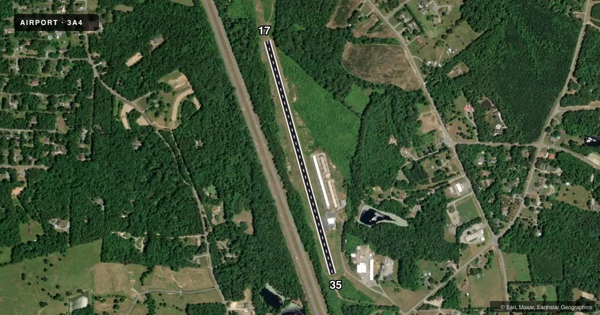
Runways & pattern
Full pagePattern entry · RWY 17
LEFT TRAFFICRunway end performance
| End | TORA | TODA | ASDA | LDA | VGSI | Approach lights | Obstruction |
|---|---|---|---|---|---|---|---|
| 17 | — | — | — | — | — | — | 16', trees, 257' from thr, 67' R of cntrln, slope 3 |
| 35 | — | — | — | — | — | — | 54', trees, 447' from thr, 17' R of cntrln, slope 4 |
Declared distances in feet. TORA = takeoff run available, TODA = takeoff distance, ASDA = accelerate-stop, LDA = landing distance.
Airport sketch
Runways drawn to scale from FAA survey coordinates, rendered over satellite imagery. Not for navigation.
Approaches & charts
Services on the field
Fuel grades, oxygen, maintenance, ramp storage and lighting — as declared to the FAA by the airport operator.
Fuel & services
- Fuel
- Not available
- Oxygen (bottled)
- Not available
- Oxygen (bulk)
- Not available
- Airframe repair
- Major
- Power plant repair
- Major
- Other services
- INSTR,RNTL
Ramp & ground
- Transient storage
- Tie-down
- Hangar
- Landing fee
- No fee published
- Lighting schedule
- SEE RMK
- Wind indicator
- Lighted
- Segmented circle
- No
Fuel & FBOs
Cheapest 100LL and Jet A on the field and nearby. Always confirm with the FBO before taxi.
Airport notes
Surface conditions, obstructions, local procedures, lighting outages and other notes published with each FAA cycle.
General notes
- RWY 17 UPHILL LNDG PREF.
- RWY 17 HAS 50 FT DROP-OFF 60 FT FROM RWY END OFFSET 30 FT BOTH SIDES OF CNTRLN.
- FOR CD CTC GREENSBORO APCH AT 743-222-6129.
- RWY 17/35 TURN-AROUNDS ARE PART OF THE RWY THERE IS NO RUNUP AREA AT EITHER END.
Lighting notes
- ACTVT MIRL RWY 17/35, 5 CLICKS ONLY - CTAF MORE THAN 5 LOCK OUT CTL FOR 10 MIN.
Runway surface & condition
- 17/35ONLY TWO END LGTS EACH SIDE.
Approach & departure obstructions
- 17HAS 15 FT TREES 22 FT FM THR, OFFSET 77 FT L OF CNTRLN.
- 356 FT EQUIPMENT 83 FT FR THR OFFSET 57 L OF CNTRLN.
- 17RWY NRS SMALLER THAN STD.
- 35RWY NRS SMALLER THAN STD.
Other notes
- CALL AHEAD FOR AVBL.
- CALL AHEAD FOR AVBL.
VFR map & nearby airports
VFR sectional. Tap any ICAO chip to open that airport.
Key facts · 3A4
Answer card- ICAO
- 3A4
- Name
- GREENSBORO EXEC
- Location
- GREENSBORO, NORTH CAROLINA
- Elevation
- 739 ft MSL
- Traffic pattern altitude
- 1,739 ft MSL (1,000 AGL)
- Control tower
- Non-towered (use CTAF)
- Total runways
- 1
- Longest runway
- 17/35 · 3,064 ft
- Published ILS approaches
- 0
- Published frequencies
- 2
- Magnetic variation
- 6°
- Current flight rules
- LIFR
- Current wind
- 000° at 0 kt
- Favored runway now
- –
Greensboro Exec sits in Greensboro, North Carolina at 739 ft MSL. It has one runway, 17/35, which is 3,064 ft long and paved with asphalt. The field is not towered. CTAF and UNICOM are both 122.8. No ILS approaches are published here.
Pattern altitude is not published. Use the standard 1,000 ft AGL for light piston traffic unless the current Chart Supplement says otherwise. That puts the normal pattern reference at 1,739 ft MSL based on the field elevation. Runway 17 is the preferred uphill landing. Be ready for the published runway 17 trees near the threshold. There is also a drop-off past the 17 end. Runway 35 has equipment near the threshold. The runway numbers are smaller than standard. The runway lights on 17/35 are activated by 5 clicks only. If the CTAF is used more than 5 times, the control locks out for 10 minutes.
No on-field FBOs are listed in the facts. Call ahead for availability before you go. For clearance delivery, contact Greensboro Approach at 743-222-6129. There is no separate runup area at either end. The turn-arounds are part of the runway, so plan your ground handling carefully.