METAR & TAF 5W5
5W5 does not publish a METAR.
Showing the nearest reporting station: KHRJ (HARNETT RGNL JETPORT) · 14.5 NM away. Conditions at 5W5 may differ.
METAR · KHRJ
Observed 13:15Z
KHRJ 271315Z AUTO 00000KT 10SM SCT006 25/23 A2988 RMK AO2 T02490230
- Wind
- 000° @ 0 kt
- Visibility
- 10 SM
- Temp / Dew
- 25°C / 23°C
- Altimeter
- 29.88 inHg
- Clouds
- SCT
- Density alt
- 1,551 ft
- Ceiling
- Unlimited
- Rules
- VFR
Airport info & contacts
Manager on record, flight service, ARTCC, attendance schedule and pattern altitude — published by the FAA and refreshed every 28 days.
Location
- From city
- 11 NM SW
- VFR sectional
- CHARLOTTE
- ARTCC
- ZDC · WASHINGTON
- NOTAM facility
- RDU (NOTAM-D)
Airport manager
- Name
- MATTEA WILLIAMS
- Phone
- 704-497-9824
- Address
- 3212 AIR PARK ROAD, FUQUAY-VARINA NC 27526
Flight service · Hours
- FSS RDU
- RALEIGH1-800-WX-BRIEF
- Attendance
- IREG
Frequencies
Tap any row to copy the frequency to your clipboard.
Runways & pattern
Full pagePattern entry · RWY 16
LEFT TRAFFICRunway end performance
| End | TORA | TODA | ASDA | LDA | VGSI | Approach lights | Obstruction |
|---|---|---|---|---|---|---|---|
| 16 | — | — | — | — | — | — | 60', trees, 201' from thr, 0' R of cntrln, slope 0 |
| 34 | — | — | — | — | — | — | 65', trees, 669' from thr, 25' R of cntrln, slope 7 |
Declared distances in feet. TORA = takeoff run available, TODA = takeoff distance, ASDA = accelerate-stop, LDA = landing distance.
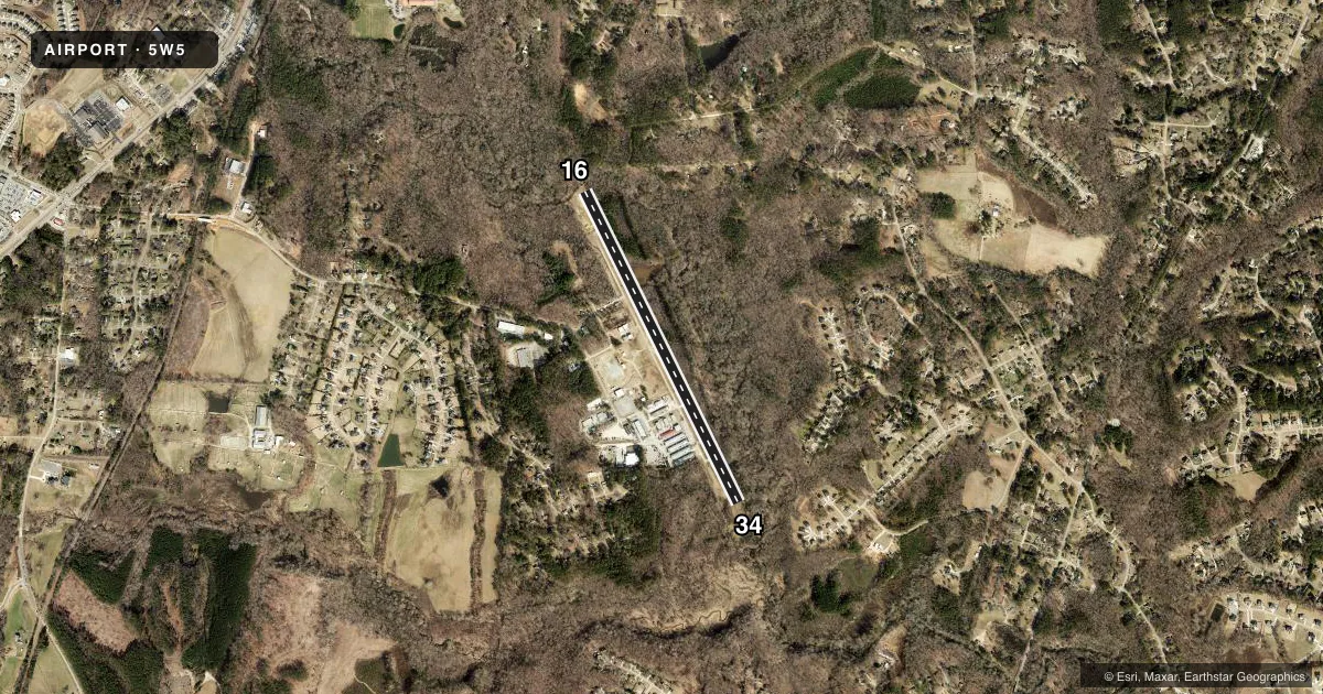
Airport sketch
Runways drawn to scale from FAA survey coordinates, rendered over satellite imagery. Not for navigation.
Approaches & charts
Services on the field
Fuel grades, oxygen, maintenance, ramp storage and lighting — as declared to the FAA by the airport operator.
Fuel & services
- Fuel
- 100LL
- Oxygen (bottled)
- Not available
- Oxygen (bulk)
- Not available
- Airframe repair
- Not available
- Power plant repair
- Not available
Ramp & ground
- Transient storage
- Tie-down
- Hangar
- Landing fee
- No fee published
- Lighting schedule
- SEE RMK
- Beacon schedule
- SS-SR
- Beacon
- White / Green (civil land)(WG)
- Wind indicator
- No
- Segmented circle
- No
Fuel & FBOs
Cheapest 100LL and Jet A on the field and nearby. Always confirm with the FBO before taxi.
Airport notes
Surface conditions, obstructions, local procedures, lighting outages and other notes published with each FAA cycle.
General notes
- BE ALERT FOR RISING TRRN ALL QUADS.
- TWR (500 FT AGL/ 826 FT MSL) APPROX 1.75 NM NW OF ARPT.
- TWY LGTS ONE SIDE ONLY.
- DEER ON AND INVOF ARPT.
- FOR CD CTC RALEIGH APCH AT 919-380-3144.
- NGT LDGS NOT RCMDD DUE TO NO THR LGTS.
Lighting notes
- DUSK-2400 ACTVT LIRL - CTAF. NO CTAF PRIOR TO DUSK.
Runway surface & condition
- 16/34NO THR LGTS.
Approach & departure obstructions
- 1675 FT TREES 0-200 FT FROM THR OFFSET 9 FT RIGHT OF CNTRLN; 52 FT TREES 0-200 FT FROM THR OFFSET 35 FT LEFT OF CNTRLN.
- 3460 FT TREES 180 FT FROM THR OFFSET 111 FT RIGHT OF CNTRLN.
- 16CNTRLN MRKG ONLY.
- 34CNTRLN MRKG ONLY.
- 16CTLNG OBSTN EXCEEDS A 45 DEG SLP.
Other notes
- VFR USE ONLY.
VFR map & nearby airports
VFR sectional. Tap any ICAO chip to open that airport.
Key facts · 5W5
Answer card- ICAO
- 5W5
- Name
- SOUTHERN WAKE RGNL
- Location
- RALEIGH, NORTH CAROLINA
- Elevation
- 243 ft MSL
- Traffic pattern altitude
- 1,243 ft MSL (1,000 AGL)
- Control tower
- Non-towered (use CTAF)
- Total runways
- 1
- Longest runway
- 16/34 · 4,005 ft
- Published ILS approaches
- 0
- Published frequencies
- 2
- Magnetic variation
- 7°
- Current flight rules
- VFR
- Current wind
- 000° at 0 kt
- Favored runway now
- –
Southern Wake Rgnl is in Raleigh, North Carolina. The field elevation is 243 ft MSL. It has one runway, 16/34, which is 4,005 ft long and asphalt. There is no control tower. CTAF and UNICOM are both 122.7. No ILS approaches are published here.
Pattern altitude is not published. Use the standard 1,000 ft AGL for light piston traffic unless the current Chart Supplement says otherwise. That puts the pattern at 1,243 ft MSL based on the field elevation, but verify before you fly. The published remarks matter here. Runway 16 has centerline markings only. Runway 34 also has centerline markings only. There are no threshold lights. Night landings are not recommended. Low intensity runway lights are activated on CTAF from dusk to 2400 hours. There is no CTAF prior to dusk.
The airport sits in a busy Raleigh area with rising terrain in all quadrants. Deer are also reported on and near the field. The tower is 500 ft AGL and 826 ft MSL, about 1.75 NM northwest of the airport. For clearance delivery, contact Raleigh Approach at 919-380-3144. No on-field FBOs are listed, so call the airport operator or the field directly before arrival if you need fuel or ramp details.