METAR & TAF 3W6
3W6 does not publish a METAR.
Showing the nearest reporting station: KEYF (CURTIS L BROWN JR FLD) · 10.5 NM away. Conditions at 3W6 may differ.
METAR · KEYF
Observed 03:35Z
KEYF 270335Z AUTO 20005KT 10SM SCT075 24/23 A2990 RMK AO2 T02440230
- Wind
- 200° @ 5 kt
- Visibility
- 10 SM
- Temp / Dew
- 24°C / 23°C
- Altimeter
- 29.90 inHg
- Clouds
- SCT
- Density alt
- 1,249 ft
- Ceiling
- Unlimited
- Rules
- VFR
Airport info & contacts
Manager on record, flight service, ARTCC, attendance schedule and pattern altitude — published by the FAA and refreshed every 28 days.
Location
- From city
- 0 NM E
- VFR sectional
- CHARLOTTE
- ARTCC
- ZDC · WASHINGTON
- NOTAM facility
- RDU (NOTAM-D)
Airport manager
- Name
- REYNOLD HESTER
- Phone
- (910) 876-4225
- Address
- 13442 N.C. 131, BLADENBORO NC 28320-8906
Flight service · Hours
- FSS RDU
- RALEIGH1-800-WX-BRIEF
- Attendance
- Unattended
Frequencies
Tap any row to copy the frequency to your clipboard.
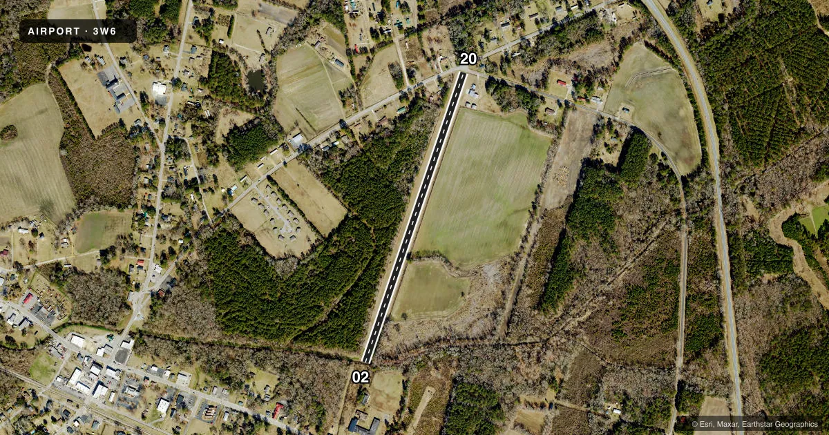
Runways & pattern
Full pagePattern entry · RWY 20
LEFT TRAFFICRunway end performance
| End | TORA | TODA | ASDA | LDA | VGSI | Approach lights | Obstruction |
|---|---|---|---|---|---|---|---|
| 02 | — | — | — | — | — | — | 63', trees, 39' from thr, 62' R of cntrln, slope 0 |
| 20 | — | — | — | — | — | — | 86', trees, 86' from thr, 48' R of cntrln, slope 1 |
Declared distances in feet. TORA = takeoff run available, TODA = takeoff distance, ASDA = accelerate-stop, LDA = landing distance.
Airport sketch
Runways drawn to scale from FAA survey coordinates, rendered over satellite imagery. Not for navigation.
Approaches & charts
Services on the field
Fuel grades, oxygen, maintenance, ramp storage and lighting — as declared to the FAA by the airport operator.
Fuel & services
- Fuel
- Not available
- Oxygen (bottled)
- Not available
- Oxygen (bulk)
- Not available
Ramp & ground
- Transient storage
- Tie-down
- Landing fee
- No fee published
- Wind indicator
- Yes
- Segmented circle
- No
Fuel & FBOs
Cheapest 100LL and Jet A on the field and nearby. Always confirm with the FBO before taxi.
Airport notes
Surface conditions, obstructions, local procedures, lighting outages and other notes published with each FAA cycle.
General notes
- RWY 20 HAS 94 FT TREES 124 FT FROM THR OFFSET 32 FT RIGHT OF CNTRLN AND 96 FT TREES 260 FT FROM THR OFFSET 95 FT LEFT OF CNTRLN.
- 80 FT TREES WEST EDGE OF RWY THR TO THR & 80 FT TREES EAST EDGE OF RWY 02 FM THR TO 500 FT.
- 20 FT WIDE BY 10 FT DEEP DRAINAGE CANAL CROSSES RWY 02 10 FT SOUTH OF THR.
- 3 FT SIDE DRAINAGE DITCHES BOTH SIDES OF RWY AT RWY EDGES.
- FOR CD CTC WASHINGTON ARTCC AT 703-771-3587.
Runway surface & condition
- 02/20USABLE RWY WIDTH IS 125 FT.
Approach & departure obstructions
- 02CTLNG OBSTN EXCEEDS A 45 DEG SLP.
Other notes
- ESTABLISHED PRIOR TO 1959.
VFR map & nearby airports
VFR sectional. Tap any ICAO chip to open that airport.
Key facts · 3W6
Answer card- ICAO
- 3W6
- Name
- BLADENBORO
- Location
- BLADENBORO, NORTH CAROLINA
- Elevation
- 116 ft MSL
- Traffic pattern altitude
- 1,116 ft MSL (1,000 AGL)
- Control tower
- Non-towered (use CTAF)
- Total runways
- 1
- Longest runway
- 02/20 · 2,850 ft
- Published ILS approaches
- 0
- Published frequencies
- 1
- Magnetic variation
- 7°
- Current flight rules
- VFR
- Current wind
- 200° at 5 kt
- Favored runway now
- RWY 20
Bladenboro Airport (3W6) sits in Bladenboro, North Carolina. Field elevation is 116 ft MSL. The airport has one runway. Runway 02/20 is 2,850 ft long and turf. There is no control tower. CTAF is 122.9. No ILS approaches are published here.
Pattern altitude is not published. Use 1,000 ft AGL as the standard light piston pattern unless the current Chart Supplement says otherwise. That puts the pattern at 1,116 ft MSL based on the field elevation. The runway is narrow in places. Published remarks say the usable width is 125 feet. They also call out trees near both runway ends and along both sides of the strip. Runway 02 has a drainage canal crossing ten feet south of the threshold. Runway 20 has tree obstructions close to the threshold area. Plan your arrival with those limits in mind.
No on-field FBOs are listed. Check with the airport operator or call the field directly before you go if you need fuel or local handling. The airport is a turf strip with no tower, so self-announce clearly and keep an eye on traffic. For clearance delivery, the published remark points pilots to Washington ARTCC. If you need current operational detail, use the current FAA Chart Supplement before departure.