METAR & TAF KLBT
Current METAR
Observed 05:56Z
KLBT 270556Z AUTO 00000KT 10SM CLR 22/22 A2988 RMK AO2 SLP114 T02220217 10267 20222 58003
- Wind
- 000° @ 0 kt
- Visibility
- 10 SM
- Temp / Dew
- 22°C / 22°C
- Altimeter
- 29.88 inHg
- Clouds
- CLR
- Density alt
- 1,044 ft
- Ceiling
- Unlimited
- Rules
- VFR
Airport info & contacts
Manager on record, flight service, ARTCC, attendance schedule and pattern altitude — published by the FAA and refreshed every 28 days.
Location
- From city
- 3 NM W
- VFR sectional
- CHARLOTTE
- ARTCC
- ZDC · WASHINGTON
- NOTAM facility
- LBT (NOTAM-D)
Airport manager
- Name
- GARY LEWIS
- Phone
- 910-739-6480
- Address
- 163 AIRPORT BLVD, LUMBERTON NC 28358
Flight service · Hours
- FSS RDU
- RALEIGH1-800-WX-BRIEF
- Attendance
- MON-FRI · 0800-1700
- SAT-SUN · 1000-1700
Frequencies
Tap any row to copy the frequency to your clipboard.
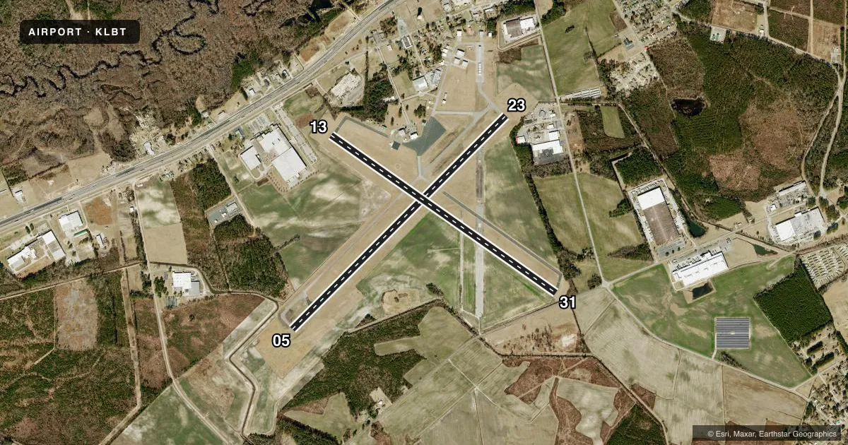
Runways & pattern
Full pagePattern entry · RWY 05
LEFT TRAFFIC| Runway | Heading (°M) | Length | Surface | Traffic |
|---|---|---|---|---|
| 05/23 | 37° / 217° | 5,505 ft | ASPH | Standard L |
| 13/31 | 117° / 297° | 5,007 ft | ASPH | Standard L |
Runway end performance
| End | TORA | TODA | ASDA | LDA | VGSI | Approach lights | Obstruction |
|---|---|---|---|---|---|---|---|
| 05 | — | — | — | — | PAPI 4-box left(3°) | — | 103', trees, 3498' from thr, 79' R of cntrln, slope 32 |
| 23 | — | — | — | — | PAPI 2-box left(3.2°) | — | 77', trees, 1776' from thr, 259' R of cntrln, slope 20 |
| 13 | — | — | — | — | — | — | 48', trees, 476' from thr, 174' R of cntrln, slope 5 |
| 31 | — | — | — | — | — | — | 53', trees, 279' from thr, 216' R of cntrln, slope 1 |
Declared distances in feet. TORA = takeoff run available, TODA = takeoff distance, ASDA = accelerate-stop, LDA = landing distance.
Airport sketch
Runways drawn to scale from FAA survey coordinates, rendered over satellite imagery. Not for navigation.
Approaches & charts
ILS · 1
Services on the field
Fuel grades, oxygen, maintenance, ramp storage and lighting — as declared to the FAA by the airport operator.
Fuel & services
- Fuel
- 100LLA1+MOGAS
- Oxygen (bottled)
- Not available
- Oxygen (bulk)
- Not available
- Airframe repair
- Major
- Power plant repair
- Major
- Other services
- CHTR,INSTR,RNTL,SALES
Ramp & ground
- Transient storage
- Tie-down
- Hangar
- Landing fee
- No fee published
- Customs
- Not available
- Lighting schedule
- SEE RMK
- Beacon schedule
- SS-SR
- Beacon
- White / Green (civil land)(WG)
- Wind indicator
- Lighted
- Segmented circle
- Yes
Fuel & FBOs
Cheapest 100LL and Jet A on the field and nearby. Always confirm with the FBO before taxi.
Airport notes
Surface conditions, obstructions, local procedures, lighting outages and other notes published with each FAA cycle.
General notes
- RWYS 05/23 & 13/31 NO LN OF SIGHT BTN RWY ENDS.
- DEER & BIRDS ON & INVOF ARPT.
- FARMING OPS NEAR RWYS AND TWYS.
- FOR CD CTC WASHINGTON ARTCC AT 703-771-3587.
Lighting notes
- ACTVT REIL RWY 05 & 23; PAPI RWY 05 & 23; MIRL RWY 05/23 - CTAF.
Fuel notes
- 100LL100LL FUEL 24 HR CREDIT CARD SVC AVBL.
- A1+PPR FOR JET A FUEL AFTER HRS, CALL AMGR 910-608-1219.
Approach & departure obstructions
- 139 FT FENCE 100 FT TO 200 FT FM THR OFFSET 240 FT L AND R OF CNTRLN.
- 2361 FT TREES 0-200 FT FM THR OFFSET 306 FT LEFT.
- 3115 FT ROAD 170 FT FM THR BOTH SIDES AND 10 FT FENCE 154 FT FM THR BOTH SIDES.
- 05APCH RATIO 26:1 AT DSPLCD THR.
- 31APCH RATIO 21:1 AT DSPLCD THR.
Other notes
- 1UNATNDD CHRISTMAS & THANKSGIVING.
VFR map & nearby airports
VFR sectional. Tap any ICAO chip to open that airport.
Key facts · KLBT
Answer card- ICAO
- KLBT
- Name
- LUMBERTON RGNL
- Location
- LUMBERTON, NORTH CAROLINA
- Elevation
- 124.6 ft MSL
- Traffic pattern altitude
- 1,124.6 ft MSL (1,000 AGL)
- Control tower
- Non-towered (use CTAF)
- Total runways
- 2
- Longest runway
- 05/23 · 5,505 ft
- Published ILS approaches
- 1
- Published frequencies
- 4
- Magnetic variation
- 8°
- Current flight rules
- VFR
- Current wind
- 000° at 0 kt
- Favored runway now
- –
Lumberton Regional Airport is in Lumberton, North Carolina. Field elevation is 124.6 ft MSL. The airport has two asphalt runways. The longest is 5,505 ft on runway 05/23. There is no control tower. CTAF and UNICOM are both 122.8. Approach and departure services are on Fayetteville frequencies. Clearance delivery goes through Washington ARTCC. The field has one ILS approach to runway 05. Pattern altitude is not published. Use 1,000 ft AGL for light piston traffic unless the current Chart Supplement says otherwise.
The on-field FBO is Lumberton Regional Airport. It carries 100LL, Jet A Prist and mogas. 100LL is available 24 hours with credit card service. Runway 05/23 has medium intensity lighting controlled by CTAF. Runway end identifier lights and PAPI are on runways 05 and 23. The airport has a few operational details worth planning for. Runways 05/23 and 13/31 do not have line of sight between runway ends. There are trees near the threshold of runway 23. There is also a fence near runway 13. A road plus fence is near runway 31. Deer, birds and farming activity are all noted near the airport. Check the current Chart Supplement for any noise or curfew restrictions before flying in.