METAR & TAF 60J
60J does not publish a METAR.
Showing the nearest reporting station: KCRE (GRAND STRAND) · 15.6 NM away. Conditions at 60J may differ.
METAR · KCRE
Observed 03:53Z
KCRE 270353Z AUTO 00000KT 10SM OVC055 25/23 A2989 RMK AO2 SLP122 T02500228
- Wind
- 000° @ 0 kt
- Visibility
- 10 SM
- Temp / Dew
- 25°C / 23°C
- Altimeter
- 29.89 inHg
- Clouds
- OVC
- Density alt
- 1,278 ft
- Ceiling
- 5,500 ft AGL
- Rules
- VFR
Airport info & contacts
Manager on record, flight service, ARTCC, attendance schedule and pattern altitude — published by the FAA and refreshed every 28 days.
Location
- From city
- 1 NM N
- VFR sectional
- CHARLOTTE
- ARTCC
- ZJX · JACKSONVILLE
- NOTAM facility
- RDU (NOTAM-D)
Airport manager
- Name
- JUSTIN WHITESIDE
- Phone
- 910-599-5651
- Address
- 6070 BEACH DRIVE SW, OCEAN ISLE BEACH NC 28469
Flight service · Hours
- FSS RDU
- RALEIGH1-800-WX-BRIEF
- Attendance
- JUN-AUG · TUE-SUN · 1000-1700
- SEP-MAY · SAT-SUN · 1000-1600
Frequencies
Tap any row to copy the frequency to your clipboard.
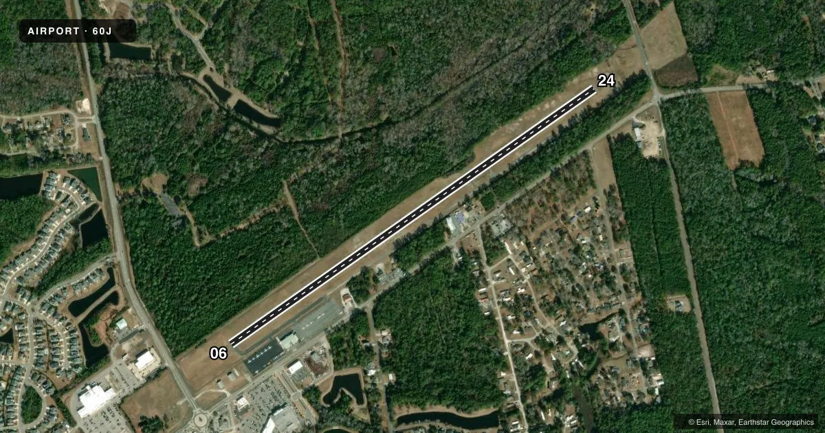
Runways & pattern
Full pagePattern entry · RWY 06
LEFT TRAFFICRunway end performance
| End | TORA | TODA | ASDA | LDA | VGSI | Approach lights | Obstruction |
|---|---|---|---|---|---|---|---|
| 06 | — | — | — | — | PAPI 2-box left(3.67°) | — | 46', tree, 917' from thr, 187' R of cntrln, slope 15 |
| 24 | — | — | — | — | PAPI 2-box left(3°) | — | 64', trees, 1359' from thr, 5' R of cntrln, slope 18 |
Declared distances in feet. TORA = takeoff run available, TODA = takeoff distance, ASDA = accelerate-stop, LDA = landing distance.
Airport sketch
Runways drawn to scale from FAA survey coordinates, rendered over satellite imagery. Not for navigation.
Approaches & charts
Services on the field
Fuel grades, oxygen, maintenance, ramp storage and lighting — as declared to the FAA by the airport operator.
Fuel & services
- Fuel
- 100LL
- Oxygen (bottled)
- Not available
- Oxygen (bulk)
- Not available
- Airframe repair
- Not available
- Power plant repair
- Not available
Ramp & ground
- Transient storage
- Tie-down
- Landing fee
- No fee published
- Lighting schedule
- SEE RMK
- Wind indicator
- Lighted
- Segmented circle
- No
Fuel & FBOs
Cheapest 100LL and Jet A on the field and nearby. Always confirm with the FBO before taxi.
Airport notes
Surface conditions, obstructions, local procedures, lighting outages and other notes published with each FAA cycle.
General notes
- PARL TWY BYD RAMP IS CLSD.
- RWY 06 HAS 48 FT MKD TRSNL PLINE +/-1000 FT FROM THR.
- FOR CD CTC MYRTLE BEACH APCH AT 843-477-2727 OR 843-477-2704, WHEN APCH CLSD CTC JACKSONVILLE ARTCC AT 904-845-1592.
- CAUTION - DTFC SHUD VFY NO LTFC BFR BLOCKING ONLY RWY EXIT.
Lighting notes
- ACTVT MIRL RWY 06/24 - CTAF. PAPI RWY 06 & RWY 24 OPER CONSLY.
Fuel notes
- 100LL24 HR SELF SVC FUEL WITH CC.
Approach & departure obstructions
- 24RWY 24 APCH SLOPE 19:1 AT DSPLCD THR.
Other notes
- VFR USE ONLY.
- 3MON-FRI ON CALL (910-575-7575); FOR SVC AFT HRS CALL 845-629-0626.
- 224 HR PILOT LOUNGE - EMERG FREQ ALLOWS ACES.
VFR map & nearby airports
VFR sectional. Tap any ICAO chip to open that airport.
Key facts · 60J
Answer card- ICAO
- 60J
- Name
- ODELL WILLIAMSON MUNI
- Location
- OCEAN ISLE BEACH, NORTH CAROLINA
- Elevation
- 32.7 ft MSL
- Traffic pattern altitude
- 1,032.7 ft MSL (1,000 AGL)
- Control tower
- Non-towered (use CTAF)
- Total runways
- 1
- Longest runway
- 06/24 · 4,198 ft
- Published ILS approaches
- 0
- Published frequencies
- 1
- Magnetic variation
- 7°
- Current flight rules
- VFR
- Current wind
- 000° at 0 kt
- Favored runway now
- –
Odell Williamson Muni sits in Ocean Isle Beach, North Carolina. Field elevation is 32.7 ft MSL. The airport has one runway, 06/24, which is 4,198 ft long. There is no control tower. CTAF is 122.9. No ILS approaches are published here, so plan for VFR operations only.
Pattern altitude is not published. Use the standard 1,000 ft AGL for light piston traffic unless the current Chart Supplement says otherwise. Ocean Isle Beach Aviation is on the field. It carries 100LL. Published remarks say 24-hour self-serve fuel is available by credit card. A 24-hour pilot lounge is also available.
There are a few operational items worth knowing before you go. Runway 06/24 lighting is activated by CTAF. Precision approach path indicators operate continuously on both ends. The airport remarks also say VFR only. Clearance delivery is handled through Myrtle Beach Approach when it is open. When approach is closed, Jacksonville ARTCC is the contact. The parallel taxiway beyond the ramp is closed. Runway 24 has a displaced threshold note with a steep approach slope. Runway 06 also has a marked transitional plane about 1,000 ft from the threshold. Watch the only runway exit and make sure the runway is clear before you block it.