METAR & TAF KSUT
Current METAR
Observed 05:15Z
KSUT 270515Z AUTO 03002KT 10SM OVC100 25/23 A2988 RMK AO2
- Wind
- 030° @ 2 kt
- Visibility
- 10 SM
- Temp / Dew
- 25°C / 23°C
- Altimeter
- 29.88 inHg
- Clouds
- OVC
- Density alt
- 1,282 ft
- Ceiling
- 10,000 ft AGL
- Rules
- VFR
Airport info & contacts
Manager on record, flight service, ARTCC, attendance schedule and pattern altitude — published by the FAA and refreshed every 28 days.
Location
- From city
- 1 NM NE
- VFR sectional
- CHARLOTTE
- ARTCC
- ZDC · WASHINGTON
- NOTAM facility
- SUT (NOTAM-D)
Airport manager
- Name
- HOWARD FRANKLIN
- Phone
- 910-457-6483
- Address
- 4015 AIRPORT ROAD, SOUTHPORT NC 28465
Flight service · Hours
- FSS RDU
- RALEIGH1-800-WX-BRIEF
- Attendance
- 0800-1800
Frequencies
Tap any row to copy the frequency to your clipboard.
Runways & pattern
Full pagePattern entry · RWY 05
LEFT TRAFFICRunway end performance
| End | TORA | TODA | ASDA | LDA | VGSI | Approach lights | Obstruction |
|---|---|---|---|---|---|---|---|
| 05 | 5,505' | 5,505' | 5,505' | 5,505' | PAPI 2-box left(3°) | — | 33', boat, 1108' from thr, 0' R of cntrln, slope 27 |
| 23 | 5,505' | 5,505' | 5,505' | 5,105' | PAPI 2-box left(4°) | — | 47', trees, 1388' from thr, 280' R of cntrln, slope 25 |
Declared distances in feet. TORA = takeoff run available, TODA = takeoff distance, ASDA = accelerate-stop, LDA = landing distance.
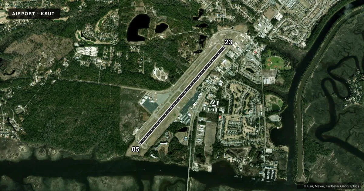
Airport sketch
Runways drawn to scale from FAA survey coordinates, rendered over satellite imagery. Not for navigation.
Approaches & charts
Services on the field
Fuel grades, oxygen, maintenance, ramp storage and lighting — as declared to the FAA by the airport operator.
Fuel & services
- Fuel
- 100LLA1+
- Oxygen (bottled)
- Not available
- Oxygen (bulk)
- Not available
- Airframe repair
- Major
- Power plant repair
- Major
- Other services
- AVNCS,INSTR,PAJA,RNTL,SALES
Ramp & ground
- Transient storage
- Tie-down
- Hangar
- Landing fee
- No fee published
- Customs
- Not available
- Lighting schedule
- SEE RMK
- Beacon schedule
- SS-SR
- Beacon
- White / Green (civil land)(WG)
- Wind indicator
- Lighted
- Segmented circle
- Yes
Fuel & FBOs
Cheapest 100LL and Jet A on the field and nearby. Always confirm with the FBO before taxi.
Airport notes
Surface conditions, obstructions, local procedures, lighting outages and other notes published with each FAA cycle.
General notes
- DEER AND BIRDS ON AND INVOF ARPT.
- 4 FT DITCH 125 FT EACH SIDE RWY 05/23.
- ARPT PHONE 910-457-6483.
- FLT TRNG & SIGHTSEEING OPNS INVOF ARPT.
- SKYDIVING OPNS.
- HEL FLT TRNG AND SIGHTSEEING TOUR OPNS INVOF ARPT.
- FOR CD CTC WILMINGTON APCH AT 910-815-4676, OR WHEN APCH CLSD CTC WASHINGTON ARTCC AT 703-771-3587.
Lighting notes
- ACTVT PAPI RWY 05 & 23; MIRL RWY 05/23 - CTAF.
Fuel notes
- A1+FUEL AVBL 24 HR SELF SVC WITH CREDIT CARD.
Approach & departure obstructions
- 23UNUSBL BYD 9 DEG LEFT AND BYD 8 DEG RIGHT OF CNTRLN.
- 23APCH RATIO 34:1 TO DSPLCD THR DUE TO 46 FT TREES 1782 FT FM DSPLCD THR OFFSET 330 FT RIGHT OF CNTRLN.
Other notes
- 1FOR SVC AFTER HRS CALL 910-540-0957.
- INSTRFULL FLT SCHOOL.
VFR map & nearby airports
VFR sectional. Tap any ICAO chip to open that airport.
Key facts · KSUT
Answer card- ICAO
- KSUT
- Name
- CAPE FEAR RGNL JETPORT/HOWIE FRANKLIN FLD
- Location
- OAK ISLAND, NORTH CAROLINA
- Elevation
- 26 ft MSL
- Traffic pattern altitude
- 1,026 ft MSL (1,000 AGL)
- Control tower
- Non-towered (use CTAF)
- Total runways
- 1
- Longest runway
- 05/23 · 5,505 ft
- Published ILS approaches
- 0
- Published frequencies
- 4
- Magnetic variation
- 8°
- Current flight rules
- VFR
- Current wind
- 030° at 2 kt
- Favored runway now
- RWY 05
Cape Fear Rgnl Jetport / Howie Franklin Fld sits in Oak Island, North Carolina. Field elevation is 26 ft MSL. The airport has one runway. Runway 05/23 is 5,505 ft long and asphalt. There is no control tower. CTAF and UNICOM are both 123.05. Wilmington Approach handles clearance delivery. No ILS approaches are published here.
Pattern altitude is not published. Use the standard 1,000 ft AGL for light piston traffic unless the current Chart Supplement says otherwise. That puts the pattern at 1,026 ft MSL based on the field elevation. Runway 23 has published centerline limits. It also has a displaced-threshold obstacle note. Trees sit close in on the 23 approach path. Runway 05/23 also has a 4-foot ditch 125 feet off each side. Deer and birds are reported on and near the airport. Expect training traffic. Flight school work, sightseeing flights, helicopter training, helicopter tours and skydiving all occur in the area.
Cape Fear Regional Jetport is the on-field FBO. It carries 100LL, Jet A and Jet A Prist. PAPI is available on runways 05 and 23. Medium-intensity runway lights on 05/23 are controlled by CTAF. For after-hours service, the published airport remarks give a separate phone number. Check the current Chart Supplement for any noise or curfew restrictions before flying into the field.