METAR & TAF KHVS
Current METAR
Observed 07:35Z
KHVS 270735Z AUTO 00000KT 2 1/2SM BR CLR 22/22 A2985 RMK AO2 LTG DSNT E
- Wind
- 000° @ 0 kt
- Visibility
- 0.5 SM
- Temp / Dew
- 22°C / 22°C
- Altimeter
- 29.85 inHg
- Clouds
- CLR
- Density alt
- 1,378 ft
- Ceiling
- Unlimited
- Rules
- LIFR
Airport info & contacts
Manager on record, flight service, ARTCC, attendance schedule and pattern altitude — published by the FAA and refreshed every 28 days.
Location
- From city
- 3 NM NW
- VFR sectional
- CHARLOTTE
- ARTCC
- ZJX · JACKSONVILLE
- NOTAM facility
- AND (NOTAM-D)
Airport manager
- Name
- BRANDON BROWN
- Phone
- 843-383-1088
- Address
- 1082 HARTSVILLE AIRPORT ROAD, HARTSVILLE SC 29550
Flight service · Hours
- FSS AND
- ANDERSON1-800-WX-BRIEF
- Attendance
- 0800-1700
Frequencies
Tap any row to copy the frequency to your clipboard.
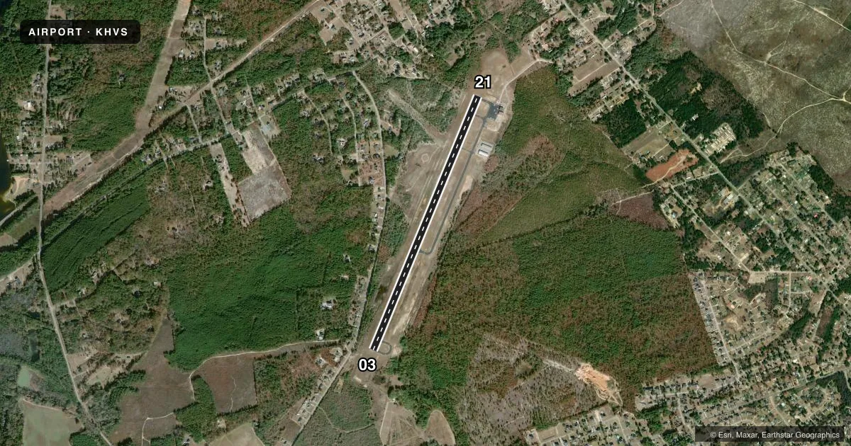
Runways & pattern
Full pagePattern entry · RWY 03
RIGHT TRAFFICRunway end performance
| End | TORA | TODA | ASDA | LDA | VGSI | Approach lights | Obstruction |
|---|---|---|---|---|---|---|---|
| 03 | — | — | — | — | PAPI 2-box left(3°) | — | — |
| 21 | — | — | — | — | PAPI 2-box left(3°) | — | — |
Declared distances in feet. TORA = takeoff run available, TODA = takeoff distance, ASDA = accelerate-stop, LDA = landing distance.
Airport sketch
Runways drawn to scale from FAA survey coordinates, rendered over satellite imagery. Not for navigation.
Approaches & charts
Services on the field
Fuel grades, oxygen, maintenance, ramp storage and lighting — as declared to the FAA by the airport operator.
Fuel & services
- Fuel
- 100LLA
- Oxygen (bottled)
- Not available
- Oxygen (bulk)
- Not available
- Airframe repair
- Minor
- Power plant repair
- Minor
- Other services
- INSTR
Ramp & ground
- Transient storage
- Tie-down
- Hangar
- Landing fee
- No fee published
- Customs
- Not available
- Lighting schedule
- SEE RMK
- Beacon schedule
- SS-SR
- Beacon
- White / Green (civil land)(WG)
- Wind indicator
- Lighted
- Segmented circle
- Yes
Fuel & FBOs
Cheapest 100LL and Jet A on the field and nearby. Always confirm with the FBO before taxi.
Airport notes
Surface conditions, obstructions, local procedures, lighting outages and other notes published with each FAA cycle.
General notes
- +300 FT ANT 2.5 MI SW OF ARPT.
- FOR CD CTC SHAW APCH AT 803-895-4884, WHEN APCH CLSD CTC JACKSONVILLE ARTCC AT 904-845-1592.
Lighting notes
- ACTVT PAPI RWY 03 & 21 - CTAF. MIRL RWY 03/21 PRESET LOW INTST DUSK-2100; TO INCR INTST AND ACTVT MIRL 03/21 AFTER 2100 - CTAF.
VFR map & nearby airports
VFR sectional. Tap any ICAO chip to open that airport.
Key facts · KHVS
Answer card- ICAO
- KHVS
- Name
- HARTSVILLE RGNL
- Location
- HARTSVILLE, SOUTH CAROLINA
- Elevation
- 363.5 ft MSL
- Traffic pattern altitude
- 1,363.5 ft MSL (1,000 AGL)
- Control tower
- Non-towered (use CTAF)
- Total runways
- 1
- Longest runway
- 03/21 · 5,000 ft
- Published ILS approaches
- 0
- Published frequencies
- 4
- Magnetic variation
- 7°
- Current flight rules
- LIFR
- Current wind
- 000° at 0 kt
- Favored runway now
- –
Hartsville Rgnl Airport sits in Hartsville, South Carolina. Field elevation is 363.5 ft MSL. The airport has one runway. Runway 03/21 is 5,000 ft of asphalt, which is the longest runway on the field. There is no control tower. Pattern altitude is not published, so plan on the standard 1,000 ft AGL for light piston traffic unless the current Chart Supplement says otherwise.
No ILS approaches are published here. CTAF and UNICOM are both 122.8. Shaw Approach handles the published approach and departure frequencies on 125.4 and 318.1. For clearance delivery, contact Shaw Approach first. If Shaw Approach is closed, use Jacksonville ARTCC.
RiseAero is on the field. It carries 100LL and Jet A. The published remarks also note a +300 ft antenna about 2.5 miles southwest of the airport. Runway lighting is CTAF-activated. The PAPI on 03 and 21 is also activated by CTAF. Medium intensity runway lights are preset to low intensity from dusk to 2100. After 2100, use CTAF to increase intensity and turn them on at medium intensity.
For a first-time arrival, the big items are simple. Expect non-towered operations. Watch the antenna southwest of the field. Check the current Chart Supplement for any updated procedures before you go.