METAR & TAF 52J
52J does not publish a METAR.
Showing the nearest reporting station: KHVS (HARTSVILLE RGNL) · 11.1 NM away. Conditions at 52J may differ.
METAR · KHVS
Observed 08:35Z
KHVS 270835Z AUTO 00000KT 4SM BR CLR 22/22 A2985 RMK AO2
- Wind
- 000° @ 0 kt
- Visibility
- 4 SM
- Temp / Dew
- 22°C / 22°C
- Altimeter
- 29.85 inHg
- Clouds
- CLR
- Density alt
- 1,188 ft
- Ceiling
- Unlimited
- Rules
- MVFR
Airport info & contacts
Manager on record, flight service, ARTCC, attendance schedule and pattern altitude — published by the FAA and refreshed every 28 days.
Location
- From city
- 2 NM N
- VFR sectional
- CHARLOTTE
- ARTCC
- ZJX · JACKSONVILLE
- NOTAM facility
- AND (NOTAM-D)
Airport manager
- Name
- GEORGE ROBERTS
- Phone
- 803-229-2679
- Address
- 412 MEADOWS LANE, BISHOPVILLE SC 29010
Flight service · Hours
- FSS AND
- ANDERSON1-800-WX-BRIEF
- Attendance
- Unattended
Frequencies
Tap any row to copy the frequency to your clipboard.
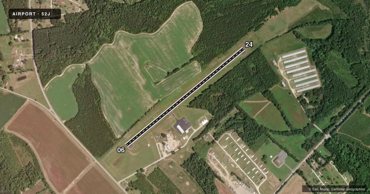
Runways & pattern
Full pagePattern entry · RWY 06
LEFT TRAFFICRunway end performance
| End | TORA | TODA | ASDA | LDA | VGSI | Approach lights | Obstruction |
|---|---|---|---|---|---|---|---|
| 06 | — | — | — | — | PAPI 2-box left(3°) | — | — |
| 24 | — | — | — | — | PAPI 2-box left(3°) | — | — |
Declared distances in feet. TORA = takeoff run available, TODA = takeoff distance, ASDA = accelerate-stop, LDA = landing distance.
Airport sketch
Runways drawn to scale from FAA survey coordinates, rendered over satellite imagery. Not for navigation.
Approaches & charts
Services on the field
Fuel grades, oxygen, maintenance, ramp storage and lighting — as declared to the FAA by the airport operator.
Fuel & services
- Fuel
- 100LL
- Oxygen (bottled)
- Not available
- Oxygen (bulk)
- Not available
- Airframe repair
- Not available
- Power plant repair
- Not available
- Other services
- AGRI,INSTR
Ramp & ground
- Transient storage
- Tie-down
- Landing fee
- No fee published
- Customs
- Not available
- Lighting schedule
- SEE RMK
- Beacon schedule
- SS-SR
- Beacon
- White / Green (civil land)(WG)
- Wind indicator
- Lighted
- Segmented circle
- Yes
Fuel & FBOs
Cheapest 100LL and Jet A on the field and nearby. Always confirm with the FBO before taxi.
Airport notes
Surface conditions, obstructions, local procedures, lighting outages and other notes published with each FAA cycle.
General notes
- WILDLIFE ON AND INVOF ARPT.
- FOR CD CTC SHAW APCH AT 803-895-4884, WHEN APCH CLSD CTC JACKSONVILLE ARTCC AT 904-845-1592.
Lighting notes
- ACTVT MIRL RY 6/24 & PAPI RY 06 AND RY 24 - CTAF.
Fuel notes
- 100LLFUEL 24 HR CREDIT CARD SVC AVBL. FOR ASSISTANCE CALL 803-484-3296/229-2679.
Approach & departure obstructions
- 06RWY 06 PAPI UNUSBL BYD 3 DEG LEFT OF CNTRLN.
- 24RWY 24 PAPI UNUSBL BYD 6 DEG LEFT OF CNTRLN.
Other notes
- EXISTED PRIOR TO 1958.
- AGRIAG OPERATIONS AT AIRPORT
VFR map & nearby airports
VFR sectional. Tap any ICAO chip to open that airport.
Key facts · 52J
Answer card- ICAO
- 52J
- Name
- LEE COUNTY/BUTTERS FLD
- Location
- BISHOPVILLE, SOUTH CAROLINA
- Elevation
- 211 ft MSL
- Traffic pattern altitude
- 1,211 ft MSL (1,000 AGL)
- Control tower
- Non-towered (use CTAF)
- Total runways
- 1
- Longest runway
- 06/24 · 3,200 ft
- Published ILS approaches
- 0
- Published frequencies
- 1
- Magnetic variation
- 5°
- Current flight rules
- MVFR
- Current wind
- 000° at 0 kt
- Favored runway now
- –
Lee County/Butters Fld sits in Bishopville, South Carolina. The field elevation is 211 ft MSL. It has one runway. Runway 06/24 is 3,200 ft long with an asphalt surface. There is no control tower. CTAF is 122.9. No ILS approaches are published here.
The pattern altitude is not published. Use the standard 1,000 ft AGL for light piston operations unless the current FAA Chart Supplement says otherwise. The on-field FBO is Lee County Airport. It carries 100LL. Published remarks say 24-hour credit card fuel service is available. Call the field if you need help with fuel access.
A few operational notes matter here. Agricultural operations occur at the airport. Wildlife is also present on and near the field. Runway 24 PAPI is unusable beyond 6 degrees left of centerline. Runway 06 PAPI is unusable beyond 3 degrees left of centerline. For clearance delivery, contact Shaw Approach when it is open. When Shaw Approach is closed, contact Jacksonville ARTCC. If you are planning a night or low-visibility arrival, verify the current lighting and approach setup before you go.