METAR & TAF 58J
58J does not publish a METAR.
Showing the nearest reporting station: KFLO (FLORENCE RGNL) · 10.3 NM away. Conditions at 58J may differ.
METAR · KFLO
Observed 05:53Z
KFLO 270553Z AUTO 00000KT 10SM CLR 23/23 A2989 RMK AO2 SLP117 T02330228 10278 20233 58004
- Wind
- 000° @ 0 kt
- Visibility
- 10 SM
- Temp / Dew
- 23°C / 23°C
- Altimeter
- 29.89 inHg
- Clouds
- CLR
- Density alt
- 1,175 ft
- Ceiling
- Unlimited
- Rules
- VFR
Airport info & contacts
Manager on record, flight service, ARTCC, attendance schedule and pattern altitude — published by the FAA and refreshed every 28 days.
Location
- From city
- 1 NM NE
- VFR sectional
- CHARLOTTE
- ARTCC
- ZJX · JACKSONVILLE
- NOTAM facility
- AND (NOTAM-D)
Airport manager
- Name
- BETTIE HUGGINS
- Phone
- (843) 229-7515
- Address
- 768 E. SMITH STREET, TIMMONSVILLE SC 29161
Flight service · Hours
- FSS AND
- ANDERSON1-800-WX-BRIEF
- Attendance
- UNATTD
Frequencies
Tap any row to copy the frequency to your clipboard.
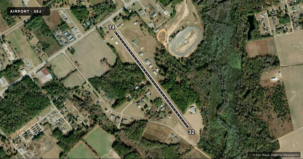
Runways & pattern
Full pagePattern entry · RWY 14
LEFT TRAFFICRunway end performance
| End | TORA | TODA | ASDA | LDA | VGSI | Approach lights | Obstruction |
|---|---|---|---|---|---|---|---|
| 14 | — | — | — | — | — | — | 15', bldg, 31' from thr, 112' R of cntrln, slope 2 |
| 32 | — | — | — | — | — | — | 68', trees, 158' from thr, 136' R of cntrln, slope 2 |
Declared distances in feet. TORA = takeoff run available, TODA = takeoff distance, ASDA = accelerate-stop, LDA = landing distance.
Airport sketch
Runways drawn to scale from FAA survey coordinates, rendered over satellite imagery. Not for navigation.
Approaches & charts
Services on the field
Fuel grades, oxygen, maintenance, ramp storage and lighting — as declared to the FAA by the airport operator.
Fuel & services
- Fuel
- Not available
- Oxygen (bottled)
- Not available
- Oxygen (bulk)
- Not available
- Airframe repair
- Not available
- Power plant repair
- Not available
- Other services
- INSTR
Ramp & ground
- Transient storage
- Tie-down
- Hangar
- Landing fee
- No fee published
- Customs
- Not available
- Lighting schedule
- SEE RMK
- Beacon schedule
- SEE RMK
- Beacon
- White / Green (civil land)(WG)
- Wind indicator
- Yes
- Segmented circle
- No
Fuel & FBOs
Cheapest 100LL and Jet A on the field and nearby. Always confirm with the FBO before taxi.
Airport notes
Surface conditions, obstructions, local procedures, lighting outages and other notes published with each FAA cycle.
General notes
- FOR CD CTC FLORENCE APCH AT 843-665-0632, WHEN APCH CLSD CTC JACKSONVILLE ARTCC AT 904-845-1592.
Lighting notes
- ACTVT ROTG BCN - CTAF.
- ACTVT LIRL RWY 14/32 - CTAF.
Other notes
- ARPT EXISTED PRIOR TO 1958.
- 14/32STANDING WATER AFTER HEAVY RAIN.
VFR map & nearby airports
VFR sectional. Tap any ICAO chip to open that airport.
Key facts · 58J
Answer card- ICAO
- 58J
- Name
- HUGGINS MEML
- Location
- TIMMONSVILLE, SOUTH CAROLINA
- Elevation
- 143 ft MSL
- Traffic pattern altitude
- 1,143 ft MSL (1,000 AGL)
- Control tower
- Non-towered (use CTAF)
- Total runways
- 1
- Longest runway
- 14/32 · 3,090 ft
- Published ILS approaches
- 0
- Published frequencies
- 1
- Magnetic variation
- 6°
- Current flight rules
- VFR
- Current wind
- 000° at 0 kt
- Favored runway now
- –
Huggins Meml Airport sits in Timmonsville, South Carolina. Field elevation is 143 ft MSL. It has one runway, 14/32, at 3,090 ft. The surface is turf. This is an untowered field, so expect self-announced traffic on CTAF 122.9.
No ILS approaches are published here. Pattern altitude is not published in the facts, so use the current Chart Supplement before you fly the pattern. The airport remarks also note that clearance delivery is handled through Florence Approach at 843-665-0632. When Florence Approach is closed, contact Jacksonville ARTCC at 904-845-1592. The rotating beacon is activated by the CTAF. Low intensity runway lights on 14/32 are also CTAF activated.
For a first-time pilot, the main things to plan for are the turf surface, the short runway length and weather effects on the field. Standing water may be present on runway 14/32 after heavy rain. That matters for braking and takeoff roll. There are no on-field FBOs listed in the facts. Verify services directly with the airport operator or call ahead before arrival. The airport existed before 1958, which is useful background but does not change the operating picture today.