METAR & TAF KFDW
Current METAR
Observed 06:55Z
KFDW 270655Z AUTO 00000KT 2SM BR SCT003 23/23 A2989 RMK AO1 VIS 3/4V5
- Wind
- 000° @ 0 kt
- Visibility
- 2 SM
- Temp / Dew
- 23°C / 23°C
- Altimeter
- 29.89 inHg
- Clouds
- SCT
- Density alt
- 1,713 ft
- Ceiling
- Unlimited
- Rules
- IFR
Airport info & contacts
Manager on record, flight service, ARTCC, attendance schedule and pattern altitude — published by the FAA and refreshed every 28 days.
Location
- From city
- 3 NM SW
- VFR sectional
- CHARLOTTE
- Pattern altitude
- 822 ft AGL · 1,400 ft MSL
- ARTCC
- ZJX · JACKSONVILLE
- NOTAM facility
- AND (NOTAM-D)
Airport manager
- Name
- DENISE BRYAN
- Phone
- (803) 718-0087
- Address
- 1291 RUNWAY RD, WINNSBORO SC 29180
Flight service · Hours
- FSS AND
- ANDERSON1-800-WX-BRIEF
- Attendance
- MAR-OCT · 0800-1800
- NOV-FEB · 0800-1700
Frequencies
Tap any row to copy the frequency to your clipboard.
Runways & pattern
Full pagePattern entry · RWY 04
LEFT TRAFFICRunway end performance
| End | TORA | TODA | ASDA | LDA | VGSI | Approach lights | Obstruction |
|---|---|---|---|---|---|---|---|
| 04 | — | — | — | — | PAPI 4-box left(3°) | — | 19', tree, 479' from thr, 166' R of cntrln, slope 14 |
| 22 | — | — | — | — | PAPI 4-box left(3°) | — | 80', tree, 2820' from thr, 297' R of cntrln, slope 32 |
Declared distances in feet. TORA = takeoff run available, TODA = takeoff distance, ASDA = accelerate-stop, LDA = landing distance.
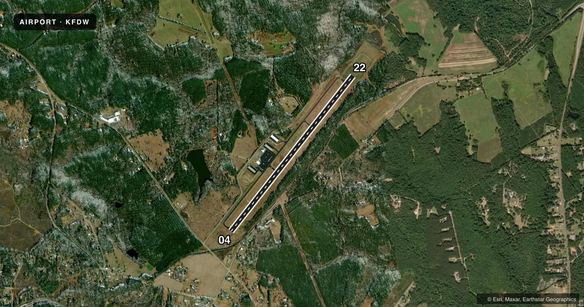
Airport sketch
Runways drawn to scale from FAA survey coordinates, rendered over satellite imagery. Not for navigation.
Approaches & charts
Services on the field
Fuel grades, oxygen, maintenance, ramp storage and lighting — as declared to the FAA by the airport operator.
Fuel & services
- Fuel
- 100LLA
- Oxygen (bottled)
- Not available
- Oxygen (bulk)
- Not available
- Airframe repair
- Major
- Power plant repair
- Major
- Other services
- AVNCS,INSTR,RNTL
Ramp & ground
- Transient storage
- Tie-down
- Landing fee
- No fee published
- Customs
- Not available
- Lighting schedule
- SEE RMK
- Beacon schedule
- SS-SR
- Beacon
- White / Green (civil land)(WG)
- Wind indicator
- Lighted
- Segmented circle
- Yes
Fuel & FBOs
Cheapest 100LL and Jet A on the field and nearby. Always confirm with the FBO before taxi.
Airport notes
Surface conditions, obstructions, local procedures, lighting outages and other notes published with each FAA cycle.
General notes
- TPA 1400 MSL.
- FOR CD CTC COLUMBIA APCH AT 803-822-5242 OR 803-822-5040.
Lighting notes
- ACTVT MIRL RY 04/22 & PAPI RYS 04 & 22 - CTAF.
Other notes
- MANAGERFOR FBO CALL (803) 635-3086.
VFR map & nearby airports
VFR sectional. Tap any ICAO chip to open that airport.
Key facts · KFDW
Answer card- ICAO
- KFDW
- Name
- FAIRFIELD COUNTY
- Location
- WINNSBORO, SOUTH CAROLINA
- Elevation
- 577.5 ft MSL
- Traffic pattern altitude
- 1,399.5 ft MSL (822 AGL)
- Control tower
- Non-towered (use CTAF)
- Total runways
- 1
- Longest runway
- 04/22 · 5,243 ft
- Published ILS approaches
- 0
- Published frequencies
- 4
- Magnetic variation
- 7°
- Current flight rules
- IFR
- Current wind
- 000° at 0 kt
- Favored runway now
- –
Fairfield County Airport sits in Winnsboro, South Carolina. The field elevation is 577.5 ft MSL. It has one runway, 04/22, which is 5,243 ft long. There is no control tower. Traffic pattern altitude is 822 ft AGL, or 1,399.5 ft MSL.
No ILS approaches are published here. For IFR work, plan around the current approach setup and get the latest clearance details before departure. Columbia Approach handles clearance delivery. The published numbers are 803-822-5242 and 803-822-5040. CTAF and UNICOM are both 123.05.
S&S Aviation is on the field. It carries 100LL and Jet A Prist. Call (803) 635-3086 for current service details. Published remarks also note medium intensity runway lights on 04/22 and PAPI on both ends. That helps after dark or in marginal light. The airport uses the common traffic advisory frequency. Keep your calls concise and listen before entering. Pattern altitude is 1,400 MSL in the remarks. That matches the published 822 ft AGL figure. For a first visit, expect a simple non-towered field with one asphalt runway and standard local traffic discipline.