METAR & TAF KMNI
Current METAR
Observed 11:55Z
KMNI 271155Z AUTO 00000KT 7SM CLR 23/23 A2987 RMK AO2
- Wind
- 000° @ 0 kt
- Visibility
- 7 SM
- Temp / Dew
- 23°C / 23°C
- Altimeter
- 29.87 inHg
- Clouds
- CLR
- Density alt
- 1,149 ft
- Ceiling
- Unlimited
- Rules
- VFR
Airport info & contacts
Manager on record, flight service, ARTCC, attendance schedule and pattern altitude — published by the FAA and refreshed every 28 days.
Location
- From city
- 7 NM S
- VFR sectional
- CHARLOTTE
- ARTCC
- ZJX · JACKSONVILLE
- NOTAM facility
- AND (NOTAM-D)
Airport manager
- Name
- MS. VICKIE WILLIAMS
- Phone
- 803-433-4004
- Address
- 8606 HIGHWAY 260, MANNING SC 29102
Flight service · Hours
- FSS AND
- ANDERSON1-800-WX-BRIEF
- Attendance
- MON-FRI · 0800-1700
Frequencies
Tap any row to copy the frequency to your clipboard.
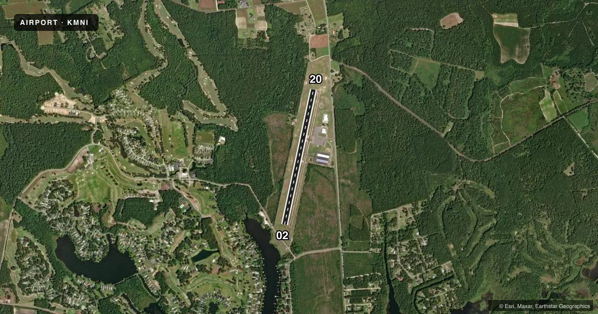
Runways & pattern
Full pagePattern entry · RWY 02
LEFT TRAFFICRunway end performance
| End | TORA | TODA | ASDA | LDA | VGSI | Approach lights | Obstruction |
|---|---|---|---|---|---|---|---|
| 02 | — | — | — | — | PAPI 2-box left(4°) | — | 50', tree, 1153' from thr, 230' R of cntrln, slope 19 |
| 20 | — | — | — | — | PAPI 2-box left(4°) | — | 58', tree, 1471' from thr, 93' R of cntrln, slope 21 |
Declared distances in feet. TORA = takeoff run available, TODA = takeoff distance, ASDA = accelerate-stop, LDA = landing distance.
Airport sketch
Runways drawn to scale from FAA survey coordinates, rendered over satellite imagery. Not for navigation.
Approaches & charts
Services on the field
Fuel grades, oxygen, maintenance, ramp storage and lighting — as declared to the FAA by the airport operator.
Fuel & services
- Fuel
- 100LLA
- Oxygen (bottled)
- Not available
- Oxygen (bulk)
- Not available
- Airframe repair
- Major
- Power plant repair
- Minor
- Other services
- AVNCS,GLD
Ramp & ground
- Transient storage
- Tie-down
- Landing fee
- No fee published
- Customs
- Not available
- Lighting schedule
- SEE RMK
- Beacon schedule
- SS-SR
- Beacon
- White / Green (civil land)(WG)
- Wind indicator
- Lighted
- Segmented circle
- Yes
Fuel & FBOs
Cheapest 100LL and Jet A on the field and nearby. Always confirm with the FBO before taxi.
Airport notes
Surface conditions, obstructions, local procedures, lighting outages and other notes published with each FAA cycle.
General notes
- GLIDER OPNS ON & INVOF ARPT.
- FOR CD CTC SHAW APCH AT 803-895-4884, WHEN APCH CLSD CTC JACKSONVILLE ARTCC AT 904-845-1592.
Lighting notes
- MIRL PRESET LOW INTST DUSK-2300; TO INCR INTST - CTAF. TO ACTVT AFT 2300 - CTAF.
Fuel notes
- 100LLSELF SVC 100LL AVBL 24 HRS WITH CREDIT CARD.
- ASELF SVC JET-A AVBL 24 HRS WITH CREDIT CARD.
VFR map & nearby airports
VFR sectional. Tap any ICAO chip to open that airport.
Key facts · KMNI
Answer card- ICAO
- KMNI
- Name
- SANTEE COOPER RGNL
- Location
- MANNING, SOUTH CAROLINA
- Elevation
- 102.7 ft MSL
- Traffic pattern altitude
- 1,102.7 ft MSL (1,000 AGL)
- Control tower
- Non-towered (use CTAF)
- Total runways
- 1
- Longest runway
- 02/20 · 3,602 ft
- Published ILS approaches
- 0
- Published frequencies
- 4
- Magnetic variation
- 6°
- Current flight rules
- VFR
- Current wind
- 000° at 0 kt
- Favored runway now
- –
Santee Cooper Rgnl sits near Manning, South Carolina. Field elevation is 102.7 ft MSL. The airport has one runway. Runway 02/20 is 3,602 ft long and paved with asphalt. There is no control tower. Shaw Approach handles clearance delivery. When Shaw Approach is closed, use Jacksonville ARTCC. No ILS approaches are published here.
Pattern altitude is not published. Use 1,000 ft AGL for light piston traffic unless the current Chart Supplement says otherwise. That puts the pattern at about 1,103 ft MSL based on the field elevation. The airport uses CTAF 122.8, which is also the UNICOM frequency.
Precision Air is on the field. It carries 100LL and Jet-A. Self-serve 100LL is available 24 hours with a credit card. Self-serve Jet-A is also available 24 hours with a credit card. Medium intensity runway lights are preset to low intensity from dusk to 2300. Use the CTAF to increase intensity. Use the CTAF again after 2300 to activate the lights.
Glider operations occur on and near the airport. That is worth planning for if you are arriving VFR. Expect a non-towered field with mixed traffic. Check the current Chart Supplement for any updated procedures before you go.