METAR & TAF KDYB
Current METAR
Observed 12:15Z
KDYB 271215Z AUTO 00000KT 1 1/4SM BR OVC003 25/25 A2985 RMK AO2
- Wind
- 000° @ 0 kt
- Visibility
- 0.25 SM
- Temp / Dew
- 25°C / 25°C
- Altimeter
- 29.85 inHg
- Clouds
- OVC
- Density alt
- 1,356 ft
- Ceiling
- 300 ft AGL
- Rules
- LIFR
Airport info & contacts
Manager on record, flight service, ARTCC, attendance schedule and pattern altitude — published by the FAA and refreshed every 28 days.
Location
- From city
- 5 NM NW
- VFR sectional
- CHARLOTTE
- ARTCC
- ZJX · JACKSONVILLE
- NOTAM facility
- AND (NOTAM-D)
Airport manager
- Name
- JEFFREY CRAVEN
- Phone
- 843-867-3927
- Address
- 898 GREYBACK RD, P.O. BOX 3, SUMMERVILLE SC 29483
Flight service · Hours
- FSS AND
- ANDERSON1-800-WX-BRIEF
- Attendance
- MON - FRI · 0800 - 1800
- SAT - SUN · 0830 - 1700
Frequencies
Tap any row to copy the frequency to your clipboard.
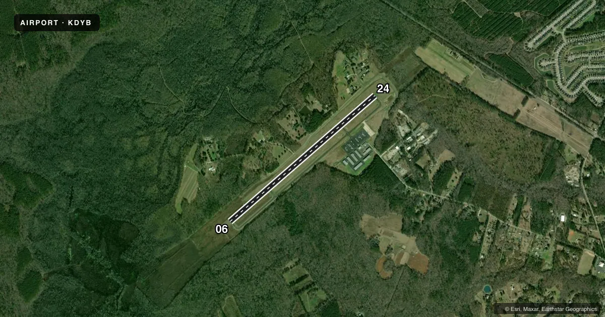
Runways & pattern
Full pagePattern entry · RWY 06
RIGHT TRAFFICRunway end performance
| End | TORA | TODA | ASDA | LDA | VGSI | Approach lights | Obstruction |
|---|---|---|---|---|---|---|---|
| 06 | — | — | — | — | — | — | trees, slope 34 |
| 24 | — | — | — | — | — | — | 75', tree, 1560' from thr, 221' R of cntrln, slope 18 |
Declared distances in feet. TORA = takeoff run available, TODA = takeoff distance, ASDA = accelerate-stop, LDA = landing distance.
Airport sketch
Runways drawn to scale from FAA survey coordinates, rendered over satellite imagery. Not for navigation.
Approaches & charts
Services on the field
Fuel grades, oxygen, maintenance, ramp storage and lighting — as declared to the FAA by the airport operator.
Fuel & services
- Fuel
- 100LLA+
- Airframe repair
- Major
- Power plant repair
- Major
- Other services
- INSTR
Ramp & ground
- Transient storage
- Tie-down
- Lighting schedule
- SEE RMK
- Beacon schedule
- SS-SR
- Beacon
- White / Green (civil land)(WG)
- Wind indicator
- Lighted
- Segmented circle
- Yes
Fuel & FBOs
Cheapest 100LL and Jet A on the field and nearby. Always confirm with the FBO before taxi.
Airport notes
Surface conditions, obstructions, local procedures, lighting outages and other notes published with each FAA cycle.
General notes
- FOR FBO CALL (843) 806-1180.
- BANNER TOWING 1500/BLO INTMT DAILY, SOUTH SIDE RWY 06/24.
- FOR CD CTC CHARLESTON APCH AT 843-414-2832.
- MOWING OPS ON WEDS NEAR ACTV RWYS/TWYS DURG GROWING SEASON.
- VISIT DORCHESTERCOUNTYSC.GOV/GOVERNMENT/ADMINISTRATIVE-SERVICES/AIRPORT FOR AIRFIELD STS AND OTHER ARPT INFO.
- CURRENT AWOS INFO - KDYB.AWOSNET.COM
Lighting notes
- MIRL RWY 06/24 OPER DUSK-2200; TO ACTVT AFTER 2200 - CTAF.
Other notes
- PRVDD VFR ONLY.
VFR map & nearby airports
VFR sectional. Tap any ICAO chip to open that airport.
Key facts · KDYB
Answer card- ICAO
- KDYB
- Name
- SUMMERVILLE
- Location
- SUMMERVILLE, SOUTH CAROLINA
- Elevation
- 55.8 ft MSL
- Traffic pattern altitude
- 1,055.8 ft MSL (1,000 AGL)
- Control tower
- Non-towered (use CTAF)
- Total runways
- 1
- Longest runway
- 06/24 · 5,000 ft
- Published ILS approaches
- 0
- Published frequencies
- 4
- Magnetic variation
- 7°
- Current flight rules
- LIFR
- Current wind
- 000° at 0 kt
- Favored runway now
- –
Summerville Airport (KDYB) sits in Summerville, South Carolina. Field elevation is 55.8 ft MSL. The airport has one runway, 06/24, which is 5,000 ft long. It is a VFR-only field. No ILS approaches are published.
There is no control tower. CTAF and UNICOM are both 123.0. Clearance delivery is handled through Charleston Approach. Published frequencies also include Charleston approach and departure on 120.7 and 306.925. Pattern altitude is not published. Use 1,000 ft AGL for light piston traffic unless the current Chart Supplement says otherwise.
Dorchester County FBO is on the field. It carries 100LL and Jet A. The main FBO number is (843) 806-1180. Published remarks also note that runway lights on 06/24 are medium intensity. They run from dusk to 2200. After 2200, pilots can activate them on CTAF. Mowing happens on Wednesdays near active pavement during the growing season. Banner towing may occur south of runway 06/24 at 1,500 ft below intermittent daily. For a first visit, plan for an uncontrolled airport with active local traffic. Check the current Chart Supplement for any updated operating notes before you go.