METAR & TAF KCHS
Current METAR
Observed 05:56Z
KCHS 270556Z 33005KT 9SM FEW020 SCT200 24/24 A2984 RMK AO2 SLP105 T02440244 10278 20244 58010
- Wind
- 330° @ 5 kt
- Visibility
- 9 SM
- Temp / Dew
- 24°C / 24°C
- Altimeter
- 29.84 inHg
- Clouds
- SCT
- Density alt
- 1,236 ft
- Ceiling
- Unlimited
- Rules
- VFR
Airport info & contacts
Manager on record, flight service, ARTCC, attendance schedule and pattern altitude — published by the FAA and refreshed every 28 days.
Location
- From city
- 9 NM NW
- VFR sectional
- CHARLOTTE
- ARTCC
- ZJX · JACKSONVILLE
- NOTAM facility
- CHS (NOTAM-D)
Airport manager
- Name
- ELLIOTT SUMMEY
- Phone
- 843-761-7000
- Address
- 5500 INTL BLVD, CHARLESTON SC 29418
Flight service · Hours
- FSS AND
- ANDERSON1-800-WX-BRIEF
- Attendance
- ALL
Frequencies
Tap any row to copy the frequency to your clipboard.
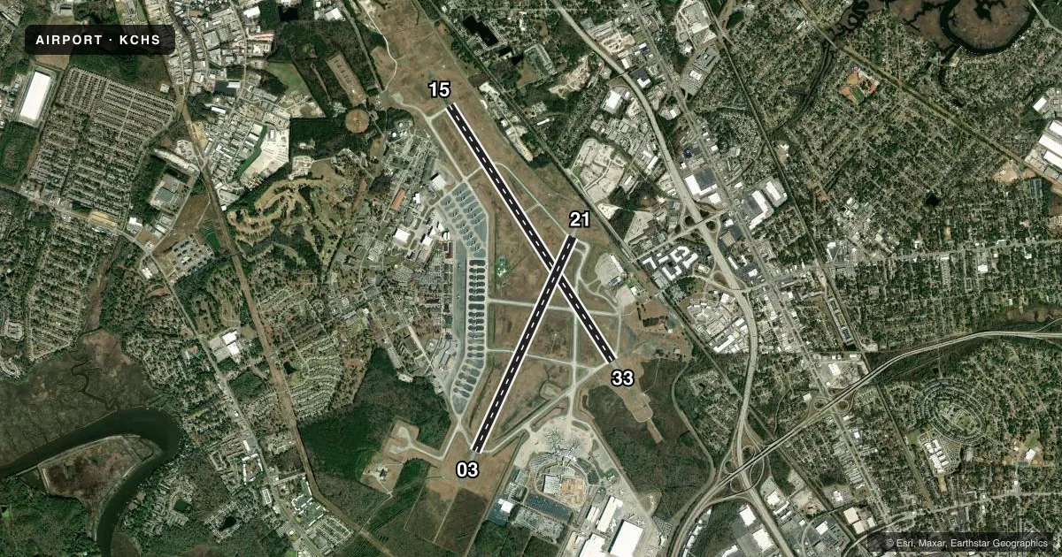
Runways & pattern
Full pagePattern entry · RWY 33
LEFT TRAFFIC| Runway | Heading (°M) | Length | Surface | Traffic |
|---|---|---|---|---|
| 15/33Favored | 140° / 320° | 9,001 ft | CONC | Standard L |
| 03/21 | 17° / 197° | 7,000 ft | CONC | Standard L |
Runway end performance
| End | TORA | TODA | ASDA | LDA | VGSI | Approach lights | Obstruction |
|---|---|---|---|---|---|---|---|
| 15 | — | — | — | — | PAPI 4-box left(3°) | ALSF2 | — |
| 33 | — | — | — | — | PAPI 4-box left(3°) | MALSR | — |
| 03 | — | — | — | — | PAPI 4-box left(3°) | — | — |
| 21 | — | — | — | — | PAPI 4-box left(3°) | — | — |
Declared distances in feet. TORA = takeoff run available, TODA = takeoff distance, ASDA = accelerate-stop, LDA = landing distance.
Airport sketch
Runways drawn to scale from FAA survey coordinates, rendered over satellite imagery. Not for navigation.
Approaches & charts
ILS · 2
Services on the field
Fuel grades, oxygen, maintenance, ramp storage and lighting — as declared to the FAA by the airport operator.
Fuel & services
- Fuel
- 100A1+
- Oxygen (bottled)
- Not available
- Oxygen (bulk)
- High pressure
- Airframe repair
- Major
- Power plant repair
- Major
- Other services
- AVNCS,CHTR,SALES
Ramp & ground
- Transient storage
- Tie-down
- Hangar
- Landing fee
- No fee published
- Customs
- Not available
- Beacon schedule
- SS-SR
- Beacon
- White / Green (civil land)(WG)
- Wind indicator
- Yes
- Segmented circle
- No
Fuel & FBOs
Cheapest 100LL and Jet A on the field and nearby. Always confirm with the FBO before taxi.
Airport notes
Surface conditions, obstructions, local procedures, lighting outages and other notes published with each FAA cycle.
General notes
- LIQUID OXYGEN SERVING AVBL TO MILITARY.
- NO STUDENT SOLO TOUCH AND GO LANDING ALLOWED.
- PPR FOR PARKING OF GENERAL AVIATION ACFT ON TERMINAL RAMP CTC 843-767-1100.
- INTENSIVE HEAVY MIL JETS & OTHER MISC ACFT EXECUTING NUMEROUS CARGO & PERSONNEL DROPS, HIGH SPEED LOW-LEVEL FORMATION FLTS & MISC AIR-TO-GROUND OPNS.
- PARKING ON TERMINAL APRON RESTRICTED TO COMMERCIAL AIR CARRIER AND ACFT FOR CUSTOMS CLEARANCE BY PRIOR ARRANGEMENT ONLY.
- JASU: 8(MD-3M) 2(MA-1A) (M32A-60) (M32A-60A)
- FLUID: SOAP - ROUTINE SOAP SAMPLES NOT AVBL; SP PRESAIR LHOX LOX
- OIL: NON-DETERGENT OIL NOT AVBL FOR PISTON ACFT. O-128-133-148(MIL)
- SEE FLIP AP/1 SUPPLEMENTARY ARPT RMK.
- RSTD: ALL INBD VIP CODE 7 OR HI, PAX, CARGO ACFT MUST CTC PALMETTO OPS NO LATER THAN 30 MIN PRIOR TO LDG.
- RSTD: AMC ACFT OPR RSTD DUR BIRD WATCH COND MODERATE (TKOF OR LDG PERMS ONLY WHEN DEP/ARR RTE AVOID IDENT BIRD ACT, NO LCL IFR/VFR TFC PAT ACFT) AND SEVERE (TKOF AND LDG PROH WO OG/CC APVL), CTC PALMETTO OPS FOR CURRENT BIRD WATCH COND.
- RSTD: ALL ACFT MUST CTC PALMETTO OPS PRIOR TO ENTERING MIL RAMP FOR PRK ASGN.
- RSTD: NON-AMC AIRCREWS REQ RON SVC CTC COMD POST (PALMETTO OPS) DSN 673-8400, C843-963-8400 PRIOR ARR. TRML APN RSTD TO COML AIR CARRIER AND ACFT FOR CSTMS CLNC BY PPR.
- CAUTION: MIGRATORY BIRD SEASON PHASE II 1-15 APR AND 1 AUG-30 NOV. RWY 15-33 RAISED APCH LGT IN OVRN, RY 03-21 OVRN 800FT.
- TFC PAT: RECTANGULAR 1200 FT, OVERHEAD 1700 FT, LGT ACFT 700 FT, C5A 2000 FT.
- MISC: AFLD MGMT DSN 673-3024/6, C843-963-3024/6. AFLD MGMT OUT OF OFFICE CTC NR C854-274-8453. IF CIV SIDE OF ARPT IS FINAL DESTN, ACFT COMDR WILL SO INDICATE ON DD 175. DANGEROUS CARGO ACFT CTC PTD PRIM, PALMETTO OPS SECD. ALL AMC MSN ACFT CTC PALMETTO OPS WHEN WITHIN RDO RNG.
- MISC: PMSV RDO UNAVBL. PMSV/PHONE PATCH AVBL THRU 628 CP DSN 673-8400 C843-963-8400. WX FLT CLOSED WKENDS, HOL AND DOWN DAYS. MIL WX FLD AFLD SUPPORT AVBL 24/7 FOR SVR WX, C843-754-1956. MSN WX SUPPORT HRS 1100-2300Z++ MON-THU AND 1100-2100Z++ FRI, DSN 673-3016/3644, C843-963-3016, CLSD WKEND, HOL, AND DOWN DAYS. MSN WX SUPPORT BRFGS FOR AIRCREW AVBL VIA THE 260WS/BARKSDALE AFB DSN 331-2651/C318-529-2651 DUR MIL WX FLT CLOSURE HRS.
- SERVICE-LGT: AIRFIELD BEACON NOT VISIBLE FROM NW.
- MISC: TMPRY STOR OF CLASSIFIED MATERIALS: LTD CLASSIFIED STOR AVBL. 24 HR PN RQR WITH AFLD MGMT. PRIOR COORD RQR. CTC BASE OPS 24 PRIOR TO ARR. NO CLASSIFIED STOR AT COMD POST. FOR TOP SECRET STOR CTC 437 SOS 24 HR PRIOR TO ARR DSN 673-0955, C843-963-0955.
- SERVICE: KCHS MIL PROVIDES NO SECURITY AND NO ACFT SERVICES AT FBO'S AND COMMERCIAL TERMINAL.
- RSTD: RWY 03-21 CLSD 2ND TUE EA MONTH 1330-2200Z++. RWY 15-33 CLSD LAST TUE OF EA MONTH 1330-2200Z++.
- CAUTION: RY 15-33 1000 FT OVERRUNS HAS FRANGIBLE RAISED APCH LIGHTS.
- CAUTION: MIL RAMP ACFT CONTACT CHS GND CONTROL FOR ENG START & TAXI.
- RSTD: RVR AVAIL VIA FAA ATCT.
- MISC: AFLD SFC WX OBS TAKEN IAW FAA CRITERIA, NOT AF CRITERIA.
- SERVICE FUEL: ALL ACFT RQR FUEL, PLEASE HAVE IN YOUR POSSESSION THE WHITE DD FORM 1896 FUEL CARD, US GOVT AIR CARD OR YOUR BASE BILLING INFO.
- TRANS ACFT FOR MIL RAMP FOLLOW-ME RQR. MIL ACFT FOR FBO PRK/SVC RQR PPR (843-746-7600).
- CAUTION: RY 21 - FREQ PRK TRAIN CARS (25 FT AGL), CONSTRUCTION/UTILITY STORAGE YARD (20 FT AGL) 1000 FT FR THLD AND GRAVEL PILES (50 FT AGL) 1500 FT FR THLD.
- RSTD: PPR, EXC AIREVAC, SAM AND AMC GDSSII MSN, FOR NUMBER AND LCL TRNG FLT TRAN ALERT SUPPORT CTC AFLD MGMT DSN 673-3024/6, C843-963-3024/6.
- CAUTION: REDUCED FIRE SUPPORT FOR C-5 AND AN-124 ACFT, DEGRADATION OF FIRE FIGHTING CAPABILITY. C-5/AN-124 WITH EMERGENCY MUST CLOSELY COORDINATE RQR WITH PALMETTO OPS.
- CAUTION: MIL SIDE WG TIP CLNC LINES: TWY D 161 FT FR TWY CNTRLN AND RAMP INTER-TXY 115 FT FR CNTRLN.
- RSTD: C5, B747, AND AN-124 ACFT TAXI WITH OUTBOARD ENG AT IDLE.
- FUEL: A++(MIL), A+(ATLANTIC AVN, C843-746-7600) (NC-100, A1+).
- CAUTION: FUEL PIT/SWITCH OBST 36 IN HIGH LCTD 75 FT LEFT OF TWY D CNTLN N OF TWY E.
- CAUTION: RY 15-33 1 FT RAISED THLD LGT.
- MISC: PAX TRML OPR 0930-0330Z++ DLY. AFTER HRS CTC DSN 673-7005/7006 OR C843-963-7005/7006. C-17 ENG RUNNING ONLOADS/OFFLOADS AVBL 24 HR PN. CTC 437 APS DSN 673-3193/4 C843-963-3193/4 FOR COORD/APVL. PASS PAX/CARGO INFO TO PALMETTO OPS 3 HRS PRIOR TO ARR.
- SERVICE-LGT: RWY 15 ALSF-2 ALSO OPR AS SSALR DUR VMC.
- ALL AIRCRAFT USE UPPER ANTENNA UNTIL AIRBORNE.
- RWY COND CODE (RWYCC) NOT RPTD.
- AFLD GRASS CUTTING OPS CONDUCTED IN CTL MOVEMENT AREA YR ROUND; CTC AFLD MGMT FOR DLY LCTN.
- MISC: COMBAT OFF-LOAD OPS ON N END OF TWY D MUST ENSURE THAT PALLETS LAND PRIOR TO LEAD-IN LINE TO RWY 15 APCH END; CTC GND IF PALLET LANDS BYD LEAD-IN LINE.
- RSTD: EXP RWY 15/33 OPS SUSPD 1230-1300Z++DLY FOR A-G INSPECTION.
- MISC: RWY 15/33 AND 3/21 GROOVED.
Runway surface & condition
- 03/21LGTS FOR BOTH RWYS ARE AF SPEC TYPE.
Arresting gear
- 15_BAK-12TYPE-H BAK-12A(B) (1260')
- 33_BAK-12TYPE-H BAK-12A(B) (1460')
Other notes
- THIS AIRPORT HAS BEEN SURVEYED BY THE NATIONAL GEODETIC SURVEY.
- TPA: RECTANGULAR 1154 FT AGL/1200 FT MSL, OVHD 1654 FT AGL/1700 FT MSL, LGT ACFT 654 FT AGL/700 FT MSL, C5A 1954 FT AGL/ 2000 FT MSL.
- MANAGERELLIOTT SUMMEY IS THE DIR OF ARPTS FOR THE CHARLESTON REGIONAL AVN AUTH. THE AIR FORCE AIRFIELD MGR CAN BE CTCD AT 843-963-3024.
- OWNERTHIS IS A SHARED-USE AIRPORT. THE USAF OWNS AND OPERATES ALL RUNWAYS AND THE MAJORITY OF THE TAXIWAYS. THE CHARLESTON COUNTY AVIATION AUTHORITY OPERATES THE CIVILIAN TERMINAL AND ASSOCIATED TAXIWAYS.
VFR map & nearby airports
VFR sectional. Tap any ICAO chip to open that airport.
Key facts · KCHS
Answer card- ICAO
- KCHS
- Name
- CHARLESTON AFB/INTL
- Location
- CHARLESTON, SOUTH CAROLINA
- Elevation
- 46 ft MSL
- Traffic pattern altitude
- 1,046 ft MSL (1,000 AGL)
- Control tower
- Towered · 24
- Total runways
- 2
- Longest runway
- 15/33 · 9,001 ft
- Published ILS approaches
- 2
- Published frequencies
- 24
- Magnetic variation
- 7°
- Current flight rules
- VFR
- Current wind
- 330° at 5 kt
- Favored runway now
- RWY 33
Charleston AFB/Intl is in Charleston, South Carolina. The field elevation is 46 ft MSL. It has 2 concrete runways. The longest is 9,001 ft on runway 15/33. The tower is open 24 hours. ILS approaches are published for runway ends 15 and 33.
Traffic pattern altitude is published at 1,200 ft MSL. That is 1,154 ft AGL for the rectangular pattern. Light aircraft use 700 ft MSL. That is 654 ft AGL. Overhead is 1,700 ft MSL. That is 1,654 ft AGL. C5A traffic uses 2,000 ft MSL. That is 1,954 ft AGL.
Signature Aviation and Atlantic Aviation are on the field. Both carry 100LL and Jet A. If you are planning a stop, call ahead for current ramp access and service details. Military transient aircraft on the ramp need a follow-me. Military aircraft for FBO parking and service need prior permission.
There are a few field-specific items to brief before arrival. Runway 15/33 has a raised threshold light at 15. Runway 21 has parked train cars, a construction and utility storage yard, plus gravel piles near the threshold area. The airport is in Class C airspace. Check the current FAA Chart Supplement for any noise or curfew restrictions before flying in. The published remarks also note that passive radio is unavailable, so plan on using the tower and current published procedures.