METAR & TAF 5J5
5J5 does not publish a METAR.
Showing the nearest reporting station: KDYB (SUMMERVILLE) · 15.4 NM away. Conditions at 5J5 may differ.
METAR · KDYB
Observed 21:15Z
KDYB 262115Z AUTO 00000KT 4SM -RA BR SCT031 SCT040 BKN055 26/25 A2985 RMK AO2
- Wind
- 000° @ 0 kt
- Visibility
- 4 SM
- Temp / Dew
- 26°C / 25°C
- Altimeter
- 29.85 inHg
- Clouds
- BKN
- Density alt
- 1,526 ft
- Ceiling
- 5,500 ft AGL
- Rules
- MVFR
Airport info & contacts
Manager on record, flight service, ARTCC, attendance schedule and pattern altitude — published by the FAA and refreshed every 28 days.
Location
- From city
- 2 NM SE
- VFR sectional
- CHARLOTTE
- ARTCC
- ZJX · JACKSONVILLE
- NOTAM facility
- AND (NOTAM-D)
Airport manager
- Name
- BILLY N. CHAVIS
- Phone
- 803-496-3330
- Address
- 8423 OLD STATE RD, SUITE # 1,, HOLLY HILL SC 29059
Flight service · Hours
- FSS AND
- ANDERSON1-800-WX-BRIEF
- Attendance
- Unattended
Frequencies
Tap any row to copy the frequency to your clipboard.
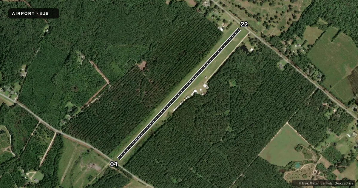
Runways & pattern
Full pagePattern entry · RWY 04
LEFT TRAFFICRunway end performance
| End | TORA | TODA | ASDA | LDA | VGSI | Approach lights | Obstruction |
|---|---|---|---|---|---|---|---|
| 04 | — | — | — | — | — | — | 81', tree, 481' from thr, 112' R of cntrln, slope 5 |
| 22 | — | — | — | — | — | — | 98', tree, 1233' from thr, 132' R of cntrln, slope 12 |
Declared distances in feet. TORA = takeoff run available, TODA = takeoff distance, ASDA = accelerate-stop, LDA = landing distance.
Airport sketch
Runways drawn to scale from FAA survey coordinates, rendered over satellite imagery. Not for navigation.
Approaches & charts
Services on the field
Fuel grades, oxygen, maintenance, ramp storage and lighting — as declared to the FAA by the airport operator.
Fuel & services
- Fuel
- Not available
- Oxygen (bottled)
- Not available
- Oxygen (bulk)
- Not available
- Airframe repair
- Not available
- Power plant repair
- Not available
Ramp & ground
- Transient storage
- Tie-down
- Landing fee
- No fee published
- Wind indicator
- Yes
- Segmented circle
- No
Fuel & FBOs
Cheapest 100LL and Jet A on the field and nearby. Always confirm with the FBO before taxi.
Airport notes
Surface conditions, obstructions, local procedures, lighting outages and other notes published with each FAA cycle.
General notes
- FOR CD CTC CHARLESTON APCH AT 843-414-2832.
Other notes
- VFR OPNS ONLY.
VFR map & nearby airports
VFR sectional. Tap any ICAO chip to open that airport.
Key facts · 5J5
Answer card- ICAO
- 5J5
- Name
- HOLLY HILL
- Location
- HOLLY HILL, SOUTH CAROLINA
- Elevation
- 96 ft MSL
- Traffic pattern altitude
- 1,096 ft MSL (1,000 AGL)
- Control tower
- Non-towered (use CTAF)
- Total runways
- 1
- Longest runway
- 04/22 · 3,900 ft
- Published ILS approaches
- 0
- Published frequencies
- 1
- Magnetic variation
- 5°
- Current flight rules
- MVFR
- Current wind
- 000° at 0 kt
- Favored runway now
- –
HOLLY HILL (5J5) sits in Holly Hill, South Carolina. Field elevation is 96 ft MSL. The airport has one runway. Runway 04/22 is 3,900 ft of turf, so plan for soft-field performance and keep an eye on surface condition before you go. This is a non-towered field. CTAF is 122.9.
No ILS approaches are published here. Published remarks say this is VFR only. They also say to contact Charleston Approach at 843-414-2832 for clearance delivery. Pattern altitude is not published. Use 1,000 ft AGL as the standard light-piston pattern unless the current Chart Supplement says otherwise. That puts the pattern at 1,096 ft MSL based on the field elevation.
There are no on-field FBOs listed. Plan fuel and services accordingly before departure. For a first-time arrival, the main things are the turf runway, the VFR-only status and the lack of published instrument approaches. Check the current Chart Supplement before you launch. That is the place to confirm any updates to remarks, pattern guidance, or local procedures.