METAR & TAF KLRO
Current METAR
Observed 00:35Z
KLRO 270035Z AUTO 00000KT 7SM VCTS CLR A2984 RMK AO2 LTG DSNT SW
- Wind
- 000° @ 0 kt
- Visibility
- 7 SM
- Temp / Dew
- —
- Altimeter
- 29.84 inHg
- Clouds
- CLR
- Density alt
- —
- Ceiling
- Unlimited
- Rules
- VFR
Airport info & contacts
Manager on record, flight service, ARTCC, attendance schedule and pattern altitude — published by the FAA and refreshed every 28 days.
Location
- From city
- 9 NM NE
- VFR sectional
- CHARLOTTE
- Pattern altitude
- 988 ft AGL · 1,000 ft MSL
- ARTCC
- ZJX · JACKSONVILLE
- NOTAM facility
- AND (NOTAM-D)
Airport manager
- Name
- ELLIOTT SUMMEY
- Phone
- 843-767-7000
- Address
- CHARLESTON CO AVIATION AUTHORITY, 5500 INTERNATIONAL BLVD, #101, CHARLESTON SC 29418-6911
Flight service · Hours
- FSS AND
- ANDERSON1-800-WX-BRIEF
- Attendance
- 0600-2000
Frequencies
Tap any row to copy the frequency to your clipboard.
Runways & pattern
Full pagePattern entry · RWY 17
LEFT TRAFFICRunway end performance
| End | TORA | TODA | ASDA | LDA | VGSI | Approach lights | Obstruction |
|---|---|---|---|---|---|---|---|
| 17 | — | — | — | — | PAPI 4-box left(4°) | — | — |
| 35 | — | — | — | — | PAPI 4-box left(4°) | — | — |
Declared distances in feet. TORA = takeoff run available, TODA = takeoff distance, ASDA = accelerate-stop, LDA = landing distance.
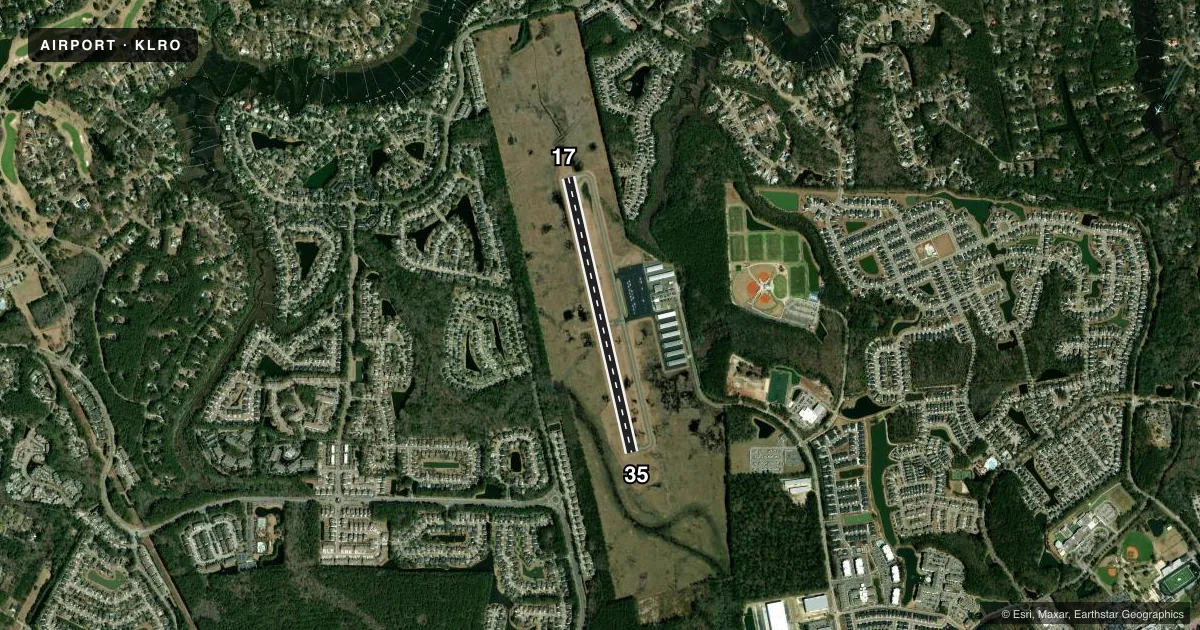
Airport sketch
Runways drawn to scale from FAA survey coordinates, rendered over satellite imagery. Not for navigation.
Approaches & charts
Services on the field
Fuel grades, oxygen, maintenance, ramp storage and lighting — as declared to the FAA by the airport operator.
Fuel & services
- Fuel
- 100LLA
- Airframe repair
- Minor
- Power plant repair
- Minor
- Other services
- INSTR,RNTL
Ramp & ground
- Transient storage
- Tie-down
- Landing fee
- No fee published
- Lighting schedule
- SEE RMK
- Beacon schedule
- SS-SR
- Beacon
- White / Green (civil land)(WG)
- Wind indicator
- Lighted
- Segmented circle
- Yes
Fuel & FBOs
Cheapest 100LL and Jet A on the field and nearby. Always confirm with the FBO before taxi.
Airport notes
Surface conditions, obstructions, local procedures, lighting outages and other notes published with each FAA cycle.
General notes
- TWO 2000 FT TOWERS APPROX 4-6 MILES EAST OF ARPT.
- DEER & BIRDS ON & INVOF ARPT.
- FOR CD CTC CHARLESTON APCH AT 843-414-2832.
- TXG ON THE FNT LINE OF THE FBO RAMP, IN FNT OF THE TRML, WILL BE RSTRD TO ACFT WITH A WINGSPAN LESS THAN 38 FT. NO ACFT, WITH A WINGSPAN THAT EXCEEDS 38 FT, IS PMTD TO PARK ON THE FNT LINE OF THE FBO RAMP OR TAX THROUGH THE FNT TAXILANE IN FNT OF THE TRML AS IT EXCEEDS SAFETY LIMITS AND WING TIP CLEARANCES. ACFT WITH WINGSPANS EXCEEDING 38 FT MUST CTC THE ARPT FBO IN ADVANCE AT 843-884-8837 FOR PRKG AND CDN PRIOR TO ARR AND MUST TAX THROUGH THE CNTR AND OUT TAXILANES OF THE FBO RAMP.
Lighting notes
- ACTVT PAPI RWY 17 & 35; MIRL RWY 17/35 - CTAF.
Other notes
- PROVIDING VFR; WILSON MEMORIAL ARPT WILL BE CLOSED WHEN EAST COOPER ARPT BECOMES OPERATIONAL.
- TPA: 988 FT AGL.
VFR map & nearby airports
VFR sectional. Tap any ICAO chip to open that airport.
Key facts · KLRO
Answer card- ICAO
- KLRO
- Name
- MT PLEASANT RGNL-FAISON FLD
- Location
- MOUNT PLEASANT, SOUTH CAROLINA
- Elevation
- 11.6 ft MSL
- Traffic pattern altitude
- 999.6 ft MSL (988 AGL)
- Control tower
- Non-towered (use CTAF)
- Total runways
- 1
- Longest runway
- 17/35 · 3,700 ft
- Published ILS approaches
- 0
- Published frequencies
- 4
- Magnetic variation
- 7°
- Current flight rules
- VFR
- Current wind
- 000° at 0 kt
- Favored runway now
- –
MT PLEASANT RGNL-FAISON FLD is in Mount Pleasant, South Carolina. Field elevation is 11.6 ft MSL. The airport has one runway, 17/35, which is 3,700 ft long. There is no control tower. Pattern altitude is 988 ft AGL, which is 999.6 ft MSL.
No ILS approaches are published here. For IFR planning, use the current FAA Chart Supplement and the Charleston Approach frequencies published for the field. Charleston County Aviation Authority is on the field. It carries AVGAS 100LL and Jet A. Call ahead at (843) 884-8837 if you need parking coordination or if your wingspan is over 38 ft. The front line of the FBO ramp and the front taxilane in front of the terminal are restricted to aircraft under that span limit.
A few operational notes matter here. PAPI lighting is available for runways 17 and 35. Medium intensity runway lighting is controlled by the CTAF. The remarks also call out deer and birds in the area. There are two 2,000 ft towers about 4 to 6 miles east of the airport. That is worth keeping in mind on departure and arrival. This is a low-elevation coastal field. The main issues are traffic awareness, obstacle awareness and staying sharp on pattern work.