METAR & TAF KARW
KARW does not publish a METAR.
Showing the nearest reporting station: KHXD (HILTON HEAD) · 11.7 NM away. Conditions at KARW may differ.
METAR · KHXD
Observed 12:50Z
KHXD 271250Z 01008KT 10SM CLR 27/26 A2987
- Wind
- 010° @ 8 kt
- Visibility
- 10 SM
- Temp / Dew
- 27°C / 26°C
- Altimeter
- 29.87 inHg
- Clouds
- CLR
- Density alt
- 1,513 ft
- Ceiling
- Unlimited
- Rules
- VFR
Airport info & contacts
Manager on record, flight service, ARTCC, attendance schedule and pattern altitude — published by the FAA and refreshed every 28 days.
Location
- From city
- 3 NM SE
- VFR sectional
- CHARLOTTE
- ARTCC
- ZJX · JACKSONVILLE
- NOTAM facility
- AND (NOTAM-D)
Airport manager
- Name
- BRANDON CHAVIS
- Phone
- 843-592-1378
- Address
- 39 AIRPORT CIRCLE, BEAUFORT SC 29907
Flight service · Hours
- FSS AND
- ANDERSON1-800-WX-BRIEF
- Attendance
- 0730-1730
Frequencies
Tap any row to copy the frequency to your clipboard.
Runways & pattern
Full pagePattern entry · RWY 07
RIGHT TRAFFICRunway end performance
| End | TORA | TODA | ASDA | LDA | VGSI | Approach lights | Obstruction |
|---|---|---|---|---|---|---|---|
| 07 | — | — | — | — | PAPI 2-box left(3.05°) | — | 65', pole, 1181' from thr, 347' R of cntrln, slope 15 |
| 25 | — | — | — | — | PAPI 2-box left(3°) | — | — |
Declared distances in feet. TORA = takeoff run available, TODA = takeoff distance, ASDA = accelerate-stop, LDA = landing distance.
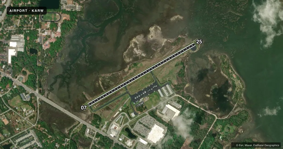
Airport sketch
Runways drawn to scale from FAA survey coordinates, rendered over satellite imagery. Not for navigation.
Approaches & charts
Services on the field
Fuel grades, oxygen, maintenance, ramp storage and lighting — as declared to the FAA by the airport operator.
Fuel & services
- Fuel
- 100LLA
- Oxygen (bottled)
- Not available
- Oxygen (bulk)
- Not available
- Airframe repair
- Major
- Power plant repair
- Major
- Other services
- INSTR,RNTL
Ramp & ground
- Transient storage
- Tie-down
- Landing fee
- No fee published
- Customs
- Not available
- Lighting schedule
- SEE RMK
- Beacon schedule
- SS-SR
- Beacon
- White / Green (civil land)(WG)
- Wind indicator
- Lighted
- Segmented circle
- Yes
Fuel & FBOs
Cheapest 100LL and Jet A on the field and nearby. Always confirm with the FBO before taxi.
Airport notes
Surface conditions, obstructions, local procedures, lighting outages and other notes published with each FAA cycle.
General notes
- DEER, SEAGULLS & GEESE ON & INVOF ARPT.
- PLINES 100 FT LOCATED 2400 FT SW AER RY 7.
- FOR CD CTC BEAUFORT APCH AT 843-228-6298, WHEN APCH CLSD CTC JACKSONVILLE ARTCC AT 904-845-1592.
Lighting notes
- MIRL RWY 07/25 PRESET LOW INTST; TO INCR INTST - CTAF.
Fuel notes
- 100LLFUEL 24 HR CREDIT CARD SVC AVBL.
Other notes
- ARPT EXISTED PRIOR TO 1958.
- 1FBO CLOSED CHRISTMAS AND THANKSGIVING
VFR map & nearby airports
VFR sectional. Tap any ICAO chip to open that airport.
Key facts · KARW
Answer card- ICAO
- KARW
- Name
- BEAUFORT EXEC
- Location
- BEAUFORT, SOUTH CAROLINA
- Elevation
- 9 ft MSL
- Traffic pattern altitude
- 1,009 ft MSL (1,000 AGL)
- Control tower
- Non-towered (use CTAF)
- Total runways
- 1
- Longest runway
- 07/25 · 3,434 ft
- Published ILS approaches
- 0
- Published frequencies
- 5
- Magnetic variation
- 7°
- Current flight rules
- VFR
- Current wind
- 010° at 8 kt
- Favored runway now
- RWY 07
Beaufort Exec is in Beaufort, South Carolina. The field elevation is 9 ft MSL. It has one runway, 07/25, which is 3,434 ft long. There is no control tower. Pattern altitude is not published, so light piston pilots should plan on the standard 1,000 ft AGL unless the current Chart Supplement says otherwise.
No ILS approaches are published here. That makes the current weather and your own arrival planning more important, especially if you are coming in at night or in lower visibility. Beaufort Approach handles clearance delivery by phone at 843-228-6298. When approach is closed, contact Jacksonville ARTCC at 904-845-1592. The airport uses CTAF 122.7 and UNICOM 122.7.
Beaufort County Airport is the on-field FBO. It carries 100LL and Jet A with Prist. Fuel with 24-hour credit card service is available. The runway lights on 07/25 are medium intensity. They are preset to low intensity. Use the common traffic advisory frequency to increase them. Expect wildlife on or near the airport. Deer, seagulls and geese are reported in the area. There are also 100 ft power lines 2,400 ft southwest of the approach end of runway 7, so keep that in mind on the 07 side.