METAR & TAF KAQX
Current METAR
Observed 11:15Z
KAQX 271115Z AUTO 00000KT 3SM BR SCT002 24/24 A2985 RMK AO2
- Wind
- 000° @ 0 kt
- Visibility
- 3 SM
- Temp / Dew
- 24°C / 24°C
- Altimeter
- 29.85 inHg
- Clouds
- SCT
- Density alt
- 1,367 ft
- Ceiling
- Unlimited
- Rules
- MVFR
Airport info & contacts
Manager on record, flight service, ARTCC, attendance schedule and pattern altitude — published by the FAA and refreshed every 28 days.
Location
- From city
- 2 NM SE
- VFR sectional
- CHARLOTTE
- ARTCC
- ZJX · JACKSONVILLE
- NOTAM facility
- AND (NOTAM-D)
Airport manager
- Name
- LONNIE BROWNING
- Phone
- 803-686-2905
- Address
- 467 AIRPORT LOOP, FAIRFAX SC 29827
Flight service · Hours
- FSS AND
- ANDERSON1-800-WX-BRIEF
- Attendance
- 0900-1700
Frequencies
Tap any row to copy the frequency to your clipboard.
Runways & pattern
Full pagePattern entry · RWY 17
LEFT TRAFFICRunway end performance
| End | TORA | TODA | ASDA | LDA | VGSI | Approach lights | Obstruction |
|---|---|---|---|---|---|---|---|
| 17 | — | — | — | — | PAPI 2-box left(3°) | — | 82', tree, 1222' from thr, 402' R of cntrln, slope 12 |
| 35 | — | — | — | — | PAPI 2-box left(3°) | — | — |
Declared distances in feet. TORA = takeoff run available, TODA = takeoff distance, ASDA = accelerate-stop, LDA = landing distance.
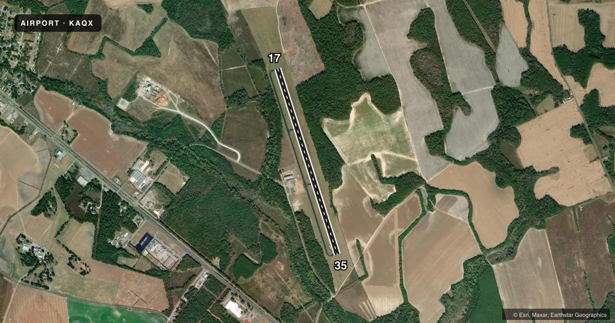
Airport sketch
Runways drawn to scale from FAA survey coordinates, rendered over satellite imagery. Not for navigation.
Approaches & charts
Services on the field
Fuel grades, oxygen, maintenance, ramp storage and lighting — as declared to the FAA by the airport operator.
Fuel & services
- Fuel
- 100LLA
- Oxygen (bottled)
- Not available
- Oxygen (bulk)
- Not available
- Airframe repair
- Not available
- Power plant repair
- Not available
- Other services
- AGRI
Ramp & ground
- Transient storage
- Tie-down
- Landing fee
- No fee published
- Customs
- Not available
- Lighting schedule
- SEE RMK
- Beacon schedule
- SS-SR
- Beacon
- White / Green (civil land)(WG)
- Wind indicator
- Lighted
- Segmented circle
- Yes
Fuel & FBOs
Cheapest 100LL and Jet A on the field and nearby. Always confirm with the FBO before taxi.
Airport notes
Surface conditions, obstructions, local procedures, lighting outages and other notes published with each FAA cycle.
General notes
- 5 FT DRAINAGE STRUCTURE LCTD 1220 FT FROM RWY 17 THLD & 75 FT L.
- FOR CD CTC JACKSONVILLE ARTCC AT 904-845-1592.
Lighting notes
- ACTVT PAPI RWY 17 & 35; MIRL RWY 17/35 - CTAF.
Fuel notes
- 100LLFOR FUEL OR SVC AFT HRS CALL 803-686-2905.
Other notes
- WINDSOCK MAY BE UNREL DUE TO PROXIMITY OF TREES AND BLDGS.
VFR map & nearby airports
VFR sectional. Tap any ICAO chip to open that airport.
Key facts · KAQX
Answer card- ICAO
- KAQX
- Name
- ALLENDALE COUNTY
- Location
- ALLENDALE, SOUTH CAROLINA
- Elevation
- 161.8 ft MSL
- Traffic pattern altitude
- 1,161.8 ft MSL (1,000 AGL)
- Control tower
- Non-towered (use CTAF)
- Total runways
- 1
- Longest runway
- 17/35 · 4,990 ft
- Published ILS approaches
- 0
- Published frequencies
- 2
- Magnetic variation
- 6°
- Current flight rules
- MVFR
- Current wind
- 000° at 0 kt
- Favored runway now
- –
Allendale County Airport sits in Allendale, South Carolina. Field elevation is 161.8 ft MSL. The airport has one runway. Runway 17/35 is 4,990 ft long with asphalt pavement. It is the longest runway on the field.
There is no control tower. CTAF and UNICOM are both 122.8. No ILS approaches are published here. The published pattern altitude is not listed, so use the standard 1,000 ft AGL pattern unless the current Chart Supplement says otherwise. That puts the pattern at about 1,162 ft MSL based on the field elevation.
Allendale County Airport is on the field and carries AVGAS 100LL plus Jet A. Call the airport at (803) 584-3801 for fuel or service. For after-hours fuel or service, the published remark gives a different number to call. The runway lighting is medium intensity on 17 and 35. A PAPI is active for both runway ends. The windsock may not be reliable because of nearby trees and buildings. There is also a 5-foot drainage structure 1,220 ft from the runway 17 threshold and 75 ft left of centerline. For clearance delivery, contact Jacksonville ARTCC.
For a first-time arrival, this is a simple non-towered field with one runway and basic visual aids. Watch the runway 17 end carefully because of the drainage structure near the approach side. Use the CTAF for traffic calls. Check the current Chart Supplement for any noise or curfew restrictions before flying in.