METAR & TAF KBNL
Current METAR
Observed 11:35Z
KBNL 271135Z AUTO 00000KT 5SM BR CLR 24/23 A2987 RMK AO2
- Wind
- 000° @ 0 kt
- Visibility
- 5 SM
- Temp / Dew
- 24°C / 23°C
- Altimeter
- 29.87 inHg
- Clouds
- CLR
- Density alt
- 1,447 ft
- Ceiling
- Unlimited
- Rules
- MVFR
Airport info & contacts
Manager on record, flight service, ARTCC, attendance schedule and pattern altitude — published by the FAA and refreshed every 28 days.
Location
- From city
- 1 NM NW
- VFR sectional
- CHARLOTTE
- ARTCC
- ZJX · JACKSONVILLE
- NOTAM facility
- AND (NOTAM-D)
Airport manager
- Name
- RICK GRIMES
- Phone
- 803-300-1190
- Address
- 155 AIRPORT ROAD, PO BOX 899, BARNWELL SC 29812
Flight service · Hours
- FSS AND
- ANDERSON1-800-WX-BRIEF
- Attendance
- 0900-1700
Frequencies
Tap any row to copy the frequency to your clipboard.
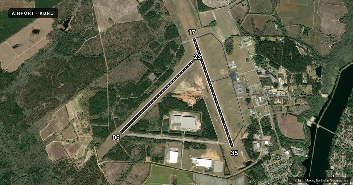
Runways & pattern
Full pagePattern entry · RWY 17
RIGHT TRAFFIC| Runway | Heading (°M) | Length | Surface | Traffic |
|---|---|---|---|---|
| 17/35 | 155° / 335° | 5,119 ft | ASPH | 17 R |
| 05/23 | 40° / 220° | 4,526 ft | ASPH | 23 R |
Runway end performance
| End | TORA | TODA | ASDA | LDA | VGSI | Approach lights | Obstruction |
|---|---|---|---|---|---|---|---|
| 17 | — | — | — | — | PAPI 2-box left(3.04°) | ODALS | 90', tree, 2606' from thr, 455' R of cntrln, slope 26 |
| 35 | — | — | — | — | PAPI 2-box left(3°) | — | 68', tree, 1374' from thr, 469' R of cntrln, slope 17 |
Declared distances in feet. TORA = takeoff run available, TODA = takeoff distance, ASDA = accelerate-stop, LDA = landing distance.
Airport sketch
Runways drawn to scale from FAA survey coordinates, rendered over satellite imagery. Not for navigation.
Approaches & charts
Services on the field
Fuel grades, oxygen, maintenance, ramp storage and lighting — as declared to the FAA by the airport operator.
Fuel & services
- Fuel
- 100LLAMOGAS
- Oxygen (bottled)
- Not available
- Oxygen (bulk)
- Not available
- Airframe repair
- Not available
- Power plant repair
- Not available
Ramp & ground
- Transient storage
- Tie-down
- Hangar
- Landing fee
- No fee published
- Customs
- Not available
- Lighting schedule
- SEE RMK
- Beacon schedule
- SS-SR
- Beacon
- White / Green (civil land)(WG)
- Wind indicator
- Lighted
- Segmented circle
- Yes
Fuel & FBOs
Cheapest 100LL and Jet A on the field and nearby. Always confirm with the FBO before taxi.
Airport notes
Surface conditions, obstructions, local procedures, lighting outages and other notes published with each FAA cycle.
General notes
- GCO AVBL ON FREQ 121.725 THRU ZJX CLEARANCE DELIVERY.
- AEROBATIC ACT WEST OF RWY 17/35. WHEN ACTIVE, INCOMING ACFT APCH ARPT FROM EAST.
- FOR CD IF UNA VIA GCO CTC JACKSONVILLE ARTCC AT 904-845-1592.
Lighting notes
- ACTVT ODALS RWY 17; MIRL RWY 17/35 - CTAF. PAPI RWY 17 & 35 OPER CONSLY, OTR TIMES - CTAF.
Fuel notes
- 100LLFUEL 24 HR CREDIT CARD SVC AVBL. EMERG FUEL SHUTOFF LCTD ON RIGHT SIDE OF TRML BLDG ATCHD TO ELECL VAULT.
Approach & departure obstructions
- 1712 FT TREES 247 FT L OF CNTRLN AND 70 FT FROM RWY THR.
Other notes
- ARPT EXISTED PRIOR TO 1958.
- 05/23RWY HAS MULT CRACKS AND RAVELING PRODUCING FOD. RWY THRS NOT MKD.
- 05/23RSTRD USE TO ACFT WEIGHING 12500 AND LESS.
VFR map & nearby airports
VFR sectional. Tap any ICAO chip to open that airport.
Key facts · KBNL
Answer card- ICAO
- KBNL
- Name
- BARNWELL RGNL
- Location
- BARNWELL, SOUTH CAROLINA
- Elevation
- 246.3 ft MSL
- Traffic pattern altitude
- 1,246.3 ft MSL (1,000 AGL)
- Control tower
- Non-towered (use CTAF)
- Total runways
- 2
- Longest runway
- 17/35 · 5,119 ft
- Published ILS approaches
- 0
- Published frequencies
- 2
- Magnetic variation
- 5°
- Current flight rules
- MVFR
- Current wind
- 000° at 0 kt
- Favored runway now
- –
Barnwell Rgnl Airport sits in Barnwell, South Carolina. Field elevation is 246.3 ft MSL. The airport has two asphalt runways. The longest is runway 17/35 at 5,119 ft. There is no control tower. CTAF and UNICOM are both 122.8. No ILS approaches are published here.
Pattern altitude is not published. Use the standard 1,000 ft AGL pattern unless local procedures or current published guidance say otherwise. The on-field FBO is Barnwell Regional Airport. It carries AVGAS 100LL, JET A PRIST and MOGAS. Fuel is available 24 hours with credit card service. If you need clearance delivery and cannot reach ground communications outlet, Jacksonville ARTCC is listed for that purpose. The ground communications outlet is on 121.725 through ZJX clearance delivery.
A few operational notes matter here. Runway 05/23 is limited to aircraft weighing 12,500 lb and less. It also has cracks and raveling that can produce foreign object debris. Its thresholds are not marked. Runway 17 has 12-foot trees left of centerline near the threshold. Aerobatic activity occurs west of runway 17/35. When that is active, plan your arrival from the east. Runway 17 has omnidirectional approach lighting. Medium intensity runway lights are on runway 17/35 and are controlled by CTAF. PAPI on 17 and 35 runs continuously. It switches to CTAF control at other times.