METAR & TAF KOKZ
KOKZ does not publish a METAR.
Showing the nearest reporting station: KMLJ (BALDWIN COUNTY RGNL) · 23.2 NM away. Conditions at KOKZ may differ.
METAR · KMLJ
Observed 21:15Z
KMLJ 262115Z AUTO 26005G11KT 10SM SCT045 SCT060 BKN080 33/23 A2986 RMK AO2
- Wind
- 260° @ 5G11 kt
- Visibility
- 10 SM
- Temp / Dew
- 33°C / 23°C
- Altimeter
- 29.86 inHg
- Clouds
- BKN
- Density alt
- 2,778 ft
- Ceiling
- 8,000 ft AGL
- Rules
- VFR
Airport info & contacts
Manager on record, flight service, ARTCC, attendance schedule and pattern altitude — published by the FAA and refreshed every 28 days.
Location
- From city
- 2 NM SW
- VFR sectional
- ATLANTA
- ARTCC
- ZTL · ATLANTA
- NOTAM facility
- MCN (NOTAM-D)
Airport manager
- Name
- RAY LAWRENCE
- Phone
- 478-552-9136
- Address
- 1726 KAOLIN RD, SANDERSVILLE GA 31082
Flight service · Hours
- FSS MCN
- MACON1-800-WX-BRIEF
- Attendance
- MON-FRI · 0800-1700
Frequencies
Tap any row to copy the frequency to your clipboard.
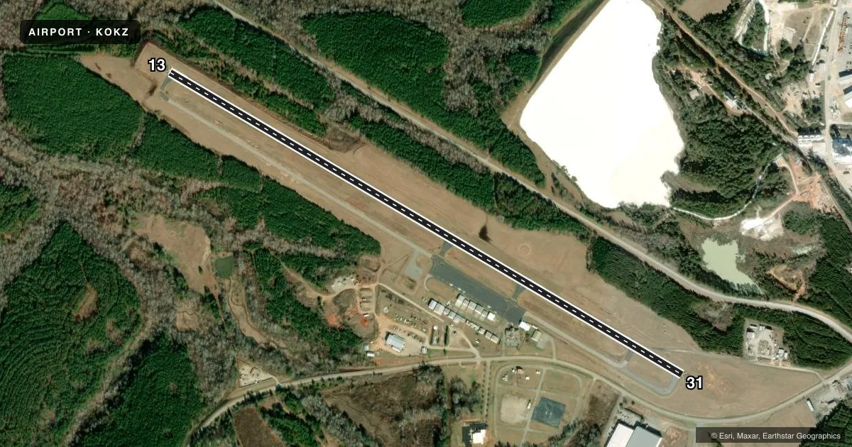
Runways & pattern
Full pagePattern entry · RWY 31
LEFT TRAFFICRunway end performance
| End | TORA | TODA | ASDA | LDA | VGSI | Approach lights | Obstruction |
|---|---|---|---|---|---|---|---|
| 13 | 5,501' | 5,501' | 5,501' | 5,501' | PAPI 2-box left(3°) | — | 21', trees, 450' from thr, 276' R of cntrln, slope 11 |
| 31 | 5,501' | 5,501' | 5,501' | 5,015' | PAPI 2-box left(3.6°) | — | 60', pole, 1099' from thr, 382' R of cntrln, slope 14 |
Declared distances in feet. TORA = takeoff run available, TODA = takeoff distance, ASDA = accelerate-stop, LDA = landing distance.
Airport sketch
Runways drawn to scale from FAA survey coordinates, rendered over satellite imagery. Not for navigation.
Approaches & charts
Services on the field
Fuel grades, oxygen, maintenance, ramp storage and lighting — as declared to the FAA by the airport operator.
Fuel & services
- Fuel
- 100LLA+
- Oxygen (bottled)
- Not available
- Oxygen (bulk)
- Not available
- Airframe repair
- Major
- Power plant repair
- Major
Ramp & ground
- Transient storage
- Tie-down
- Landing fee
- No fee published
- Customs
- Not available
- Lighting schedule
- SEE RMK
- Beacon schedule
- SS-SR
- Beacon
- White / Green (civil land)(WG)
- Wind indicator
- Lighted
- Segmented circle
- Yes
Fuel & FBOs
Cheapest 100LL and Jet A on the field and nearby. Always confirm with the FBO before taxi.
Airport notes
Surface conditions, obstructions, local procedures, lighting outages and other notes published with each FAA cycle.
General notes
- DEER ON & INVOF RYS & TWYS.
- FOR CD CTC ATLANTA APCH AT 678-364-6132, WHEN APCH CLSD CTC ATLANTA ARTCC AT 770-210-7692.
Lighting notes
- REIL RWY 13; MIRL RWY 13/31 PRESET LOW INTST DUSK-2200; TO INCR INTST & ACTVT AFT 2200 - CTAF. ACTVT PAPI RWYS 13 & 31 - CTAF.
Other notes
- OWNERAND CITY OF SANDERSVILLE
VFR map & nearby airports
VFR sectional. Tap any ICAO chip to open that airport.
Key facts · KOKZ
Answer card- ICAO
- KOKZ
- Name
- KAOLIN FLD
- Location
- SANDERSVILLE, GEORGIA
- Elevation
- 438.5 ft MSL
- Traffic pattern altitude
- 1,438.5 ft MSL (1,000 AGL)
- Control tower
- Non-towered (use CTAF)
- Total runways
- 1
- Longest runway
- 13/31 · 5,501 ft
- Published ILS approaches
- 0
- Published frequencies
- 5
- Magnetic variation
- 5°
- Current flight rules
- VFR
- Current wind
- 260° at 5 kt
- Favored runway now
- RWY 31
Kaolin Fld sits in Sandersville, Georgia. Field elevation is 438.5 ft MSL. The airport has one asphalt runway. Runway 13/31 is 5,501 ft long, which is the longest runway on the field. There is no control tower. Pattern altitude is not published, so use 1,000 ft AGL for light piston operations unless the current Chart Supplement says otherwise.
No ILS approaches are published here. CTAF and UNICOM are both 123.0. Atlanta Approach frequencies are published for arrival and departure work. For clearance delivery, the Chart Supplement says to contact Atlanta Approach at 678-364-6132. When Atlanta Approach is closed, contact Atlanta ARTCC at 770-210-7692.
Kaolin Aviation Service is on the field. It carries AVGAS 100LL and Jet A. Runway 13 has runway end identifier lights. The medium intensity runway lights on 13 and 31 are preset to low intensity from dusk to 2200. After 2200, use CTAF to increase intensity and activate the lights. The PAPI on 13 and 31 is also activated on CTAF. Deer are reported on and near the runways and taxiways, so keep a sharp scan on rollout and during taxi. This is a non-towered field. Plan your radio work and spacing before you get there.