METAR & TAF KMAC
KMAC does not publish a METAR.
Showing the nearest reporting station: KMCN (MIDDLE GEORGIA RGNL) · 8.9 NM away. Conditions at KMAC may differ.
METAR · KMCN
Observed 11:53Z
KMCN 271153Z 27005KT 5SM BR CLR 25/25 A2990 RMK AO2 SLP118 T02500250 10261 20250 53011
- Wind
- 270° @ 5 kt
- Visibility
- 5 SM
- Temp / Dew
- 25°C / 25°C
- Altimeter
- 29.90 inHg
- Clouds
- CLR
- Density alt
- 1,766 ft
- Ceiling
- Unlimited
- Rules
- MVFR
Airport info & contacts
Manager on record, flight service, ARTCC, attendance schedule and pattern altitude — published by the FAA and refreshed every 28 days.
Location
- From city
- 3 NM SE
- VFR sectional
- ATLANTA
- ARTCC
- ZTL · ATLANTA
- NOTAM facility
- MCN (NOTAM-D)
Airport manager
- Name
- DOUG FAOUR
- Phone
- 478-803-0460
- Address
- 1000 TERMINAL DRIVE, SUITE 100, MACON GA 31297
Flight service · Hours
- FSS MCN
- MACON1-800-WX-BRIEF
- Attendance
- 0700-1900
Frequencies
Tap any row to copy the frequency to your clipboard.
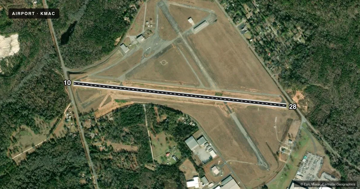
Runways & pattern
Full pagePattern entry · RWY 28
RIGHT TRAFFICRunway end performance
| End | TORA | TODA | ASDA | LDA | VGSI | Approach lights | Obstruction |
|---|---|---|---|---|---|---|---|
| 10 | 4,694' | 4,694' | 4,439' | 4,184' | PAPI 4-box right(3°) | — | 29', trees, 388' from thr, 276' R of cntrln, slope 6 |
| 28 | 4,694' | 4,694' | 4,439' | 4,184' | PAPI 4-box left(3°) | — | 32', trees, 952' from thr, 321' R of cntrln, slope 23 |
Declared distances in feet. TORA = takeoff run available, TODA = takeoff distance, ASDA = accelerate-stop, LDA = landing distance.
Airport sketch
Runways drawn to scale from FAA survey coordinates, rendered over satellite imagery. Not for navigation.
Approaches & charts
ILS · 1
Services on the field
Fuel grades, oxygen, maintenance, ramp storage and lighting — as declared to the FAA by the airport operator.
Fuel & services
- Fuel
- 100LLA+
- Oxygen (bottled)
- Not available
- Oxygen (bulk)
- Not available
- Airframe repair
- Not available
- Power plant repair
- Not available
- Other services
- INSTR
Ramp & ground
- Transient storage
- Tie-down
- Landing fee
- Yes
- Customs
- Not available
- Lighting schedule
- SEE RMK
- Beacon schedule
- SS-SR
- Beacon
- White / Green (civil land)(WG)
- Wind indicator
- Lighted
- Segmented circle
- Yes
Fuel & FBOs
Cheapest 100LL and Jet A on the field and nearby. Always confirm with the FBO before taxi.
Airport notes
Surface conditions, obstructions, local procedures, lighting outages and other notes published with each FAA cycle.
General notes
- 825 FT MSL RADIO TWR LCTD APRXLY 1 MILE SE OF ARPT.
- WILDLIFE NEAR ARPT.
- PDEW ADJ TO MOVEMENT AREAS FRM APR 1 TO NOV 1 FOR GRASS CUTTING.
- FOR CD CTC ATLANTA APCH AT 678-364-6132, WHEN APCH CLSD CTC ATLANTA ARTCC AT 770-210-7692.
- TWY A UNUSBL BY A/C GTR THAN 49 FT WINGSPAN WHILE ACFT ARR OR DEP ON RWY 10/28.
Lighting notes
- ACTVT MIRL AND PAPI RY 10/28 - CTAF.
Approach & departure obstructions
- 28RWY 28 PAPI UNUSBL BYD 7 DEG RT OF RCL.
- 10RWY 10 APPROACH SLOPE TO DSPLCD THR IS 22:1; TREES 643FT FROM DSPLCD THR 277FT RIGHT.
Other notes
- EXISTED PRIOR TO 1959.
- FOR CERTAIN SVCS.
- 1PHONE AHEAD FOR SPECIAL REQUEST. AFTER HRS CALL OUT FEES MAY APPLY.
- MANAGERMIDDLE GEORGIA REGIONAL ARPT
VFR map & nearby airports
VFR sectional. Tap any ICAO chip to open that airport.
Key facts · KMAC
Answer card- ICAO
- KMAC
- Name
- MACON DOWNTOWN
- Location
- MACON, GEORGIA
- Elevation
- 436.7 ft MSL
- Traffic pattern altitude
- 1,436.7 ft MSL (1,000 AGL)
- Control tower
- Non-towered (use CTAF)
- Total runways
- 1
- Longest runway
- 10/28 · 4,694 ft
- Published ILS approaches
- 1
- Published frequencies
- 5
- Magnetic variation
- 6°
- Current flight rules
- MVFR
- Current wind
- 270° at 5 kt
- Favored runway now
- RWY 28
Macon Downtown Airport is in Macon, Georgia. The field elevation is 436.7 ft MSL. It has one runway. Runway 10/28 is 4,694 ft long with asphalt pavement. The airport is non-towered. Pattern altitude is not published, so use the standard 1,000 ft AGL for light piston traffic unless the current Chart Supplement says otherwise.
There is one ILS approach. It serves runway 10. Medium intensity runway lights and the precision approach path indicators on runway 10/28 are activated on CTAF. The field uses CTAF 123.0 and UNICOM 123.0. Clearance delivery is handled through Atlanta Approach when available. If approach is closed, contact Atlanta ARTCC for clearance information.
Middle Georgia State University is on the field. It carries AVGAS 100LL and Jet A. Phone ahead for special requests. After-hours callout fees may apply. The published remarks also note wildlife near the airport. Taxiway A is unusable by aircraft greater than 49 ft wingspan while aircraft arrive or depart on runway 10/28. There is also a 825 ft MSL radio tower about 1 mile southeast of the airport. For a first visit, pay close attention to the runway 10 obstacle note. Watch the PAPI limits on runway 28. Keep the nearby tower in mind when planning your approach and departure.