METAR & TAF KOPN
Current METAR
Observed 13:35Z
KOPN 261335Z AUTO 30005KT 10SM SCT023 BKN027 OVC039 24/23 A3005 RMK AO2
- Wind
- 300° @ 5 kt
- Visibility
- 10 SM
- Temp / Dew
- 24°C / 23°C
- Altimeter
- 30.05 inHg
- Clouds
- OVC
- Density alt
- 1,908 ft
- Ceiling
- 2,700 ft AGL
- Rules
- MVFR
Airport info & contacts
Manager on record, flight service, ARTCC, attendance schedule and pattern altitude — published by the FAA and refreshed every 28 days.
Location
- From city
- 5 NM NE
- VFR sectional
- ATLANTA
- ARTCC
- ZTL · ATLANTA
- NOTAM facility
- OPN (NOTAM-D)
Airport manager
- Name
- MITCH ELLERBEE
- Phone
- 706-647-4500
- Address
- 2347 DEL RAY ROAD, THOMASTON GA 30286
Flight service · Hours
- FSS MCN
- MACON1-800-WX-BRIEF
- Attendance
- 0800-1800
Frequencies
Tap any row to copy the frequency to your clipboard.
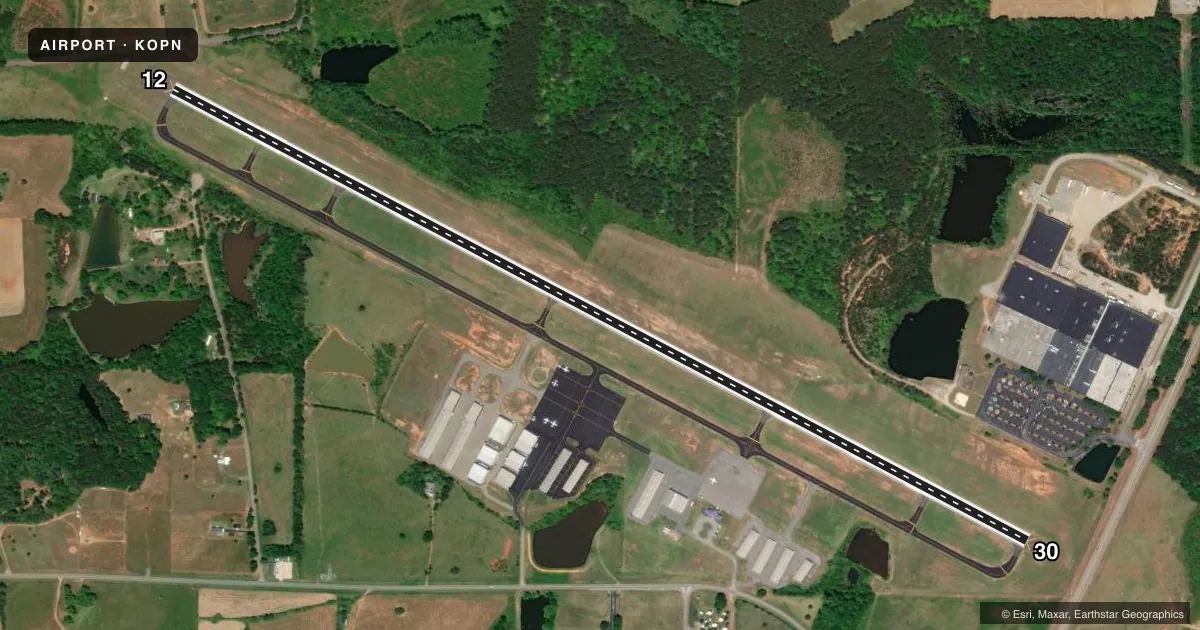
Runways & pattern
Full pagePattern entry · RWY 30
LEFT TRAFFICRunway end performance
| End | TORA | TODA | ASDA | LDA | VGSI | Approach lights | Obstruction |
|---|---|---|---|---|---|---|---|
| 12 | 6,350' | 6,350' | 6,173' | 5,525' | PAPI 2-box left(3.5°) | — | 15', road, 201' from thr, 250' R of cntrln, slope 0 |
| 30 | 6,350' | 6,350' | 5,662' | 4,962' | PAPI 2-box left(3°) | MALSR | 19', rr, 371' from thr, 524' R of cntrln, slope 9 |
Declared distances in feet. TORA = takeoff run available, TODA = takeoff distance, ASDA = accelerate-stop, LDA = landing distance.
Airport sketch
Runways drawn to scale from FAA survey coordinates, rendered over satellite imagery. Not for navigation.
Approaches & charts
ILS · 1
Services on the field
Fuel grades, oxygen, maintenance, ramp storage and lighting — as declared to the FAA by the airport operator.
Fuel & services
- Fuel
- 100LLA+
- Oxygen (bottled)
- Not available
- Oxygen (bulk)
- Not available
- Airframe repair
- Major
- Power plant repair
- Major
- Other services
- AVNCS,INSTR,PAJA,SURV
Ramp & ground
- Transient storage
- Tie-down
- Landing fee
- No fee published
- Lighting schedule
- SEE RMK
- Beacon schedule
- SS-SR
- Beacon
- White / Green (civil land)(WG)
- Wind indicator
- Lighted
- Segmented circle
- Yes
Fuel & FBOs
Cheapest 100LL and Jet A on the field and nearby. Always confirm with the FBO before taxi.
Airport notes
Surface conditions, obstructions, local procedures, lighting outages and other notes published with each FAA cycle.
General notes
- FOR CD CTC ATLANTA APCH AT 678-364-6132, WHEN APCH CLSD CTC ATLANTA ARTCC AT 770-210-7692.
Lighting notes
- ACTVT MALSR RY 30 AND PAPI RYS 12 & 30 - CTAF. MIRL RY 12/30 PRESET MED INTST DUSK-0000; AFTER 0000 ACTVT - CTAF.
Approach & departure obstructions
- 126 FT FENCE AND ROAD 198 FT LEFT 200 FT FROM RY END.
- 1234:1 APCH TO DSPLCD THLD.
- 3050:1 APCH TO DSPLCD THLD.
Other notes
- PRVDD VFR
- 1FOR AFT HRS SVC CALL 706-741-0562.
VFR map & nearby airports
VFR sectional. Tap any ICAO chip to open that airport.
Key facts · KOPN
Answer card- ICAO
- KOPN
- Name
- THOMASTON-UPSON COUNTY
- Location
- THOMASTON, GEORGIA
- Elevation
- 797.7 ft MSL
- Traffic pattern altitude
- 1,797.7 ft MSL (1,000 AGL)
- Control tower
- Non-towered (use CTAF)
- Total runways
- 1
- Longest runway
- 12/30 · 6,350 ft
- Published ILS approaches
- 1
- Published frequencies
- 5
- Magnetic variation
- 3°
- Current flight rules
- MVFR
- Current wind
- 300° at 5 kt
- Favored runway now
- RWY 30
Thomaston-Upson County Airport (KOPN) sits in Thomaston, Georgia. Field elevation is 797.7 ft MSL. The airport has one runway, 12/30, which is 6,350 ft long with an asphalt surface. There is no control tower. CTAF and UNICOM are both 122.8. The field has one ILS approach. It serves runway 30.
Pattern altitude is not published. Use the standard 1,000 ft AGL for light piston operations unless ATC or the current Chart Supplement says otherwise. The published remarks matter here. Runway 30 has MALSR lighting. The PAPI on runways 12 and 30 is activated by CTAF. The runway edge lights on 12/30 are preset from dusk to 0000. After 0000, they are also activated by CTAF. If you need after-hours service, call the number in the Chart Supplement before you go.
Thomaston-Upson County Airport is a VFR-friendly field with published approach support from Atlanta. The airport also has noted clearance slopes to the displaced thresholds on both ends. There is a fence and road near the runway 12 end. If you are planning a first visit, review the current Chart Supplement and brief the lighting activation and threshold environment before arrival. The on-field FBO is Thomaston-Upson County Airport. It carries AVGAS_100LL and JET_A_PRIST.