METAR & TAF 6A2
Current METAR
Observed 10:35Z
K6A2 271035Z AUTO 30003KT 5SM CLR 24/23 A2993 RMK AO2 LTG DSNT W
- Wind
- 300° @ 3 kt
- Visibility
- 5 SM
- Temp / Dew
- 24°C / 23°C
- Altimeter
- 29.93 inHg
- Clouds
- CLR
- Density alt
- 2,256 ft
- Ceiling
- Unlimited
- Rules
- MVFR
Airport info & contacts
Manager on record, flight service, ARTCC, attendance schedule and pattern altitude — published by the FAA and refreshed every 28 days.
Location
- From city
- 1 NM S
- VFR sectional
- ATLANTA
- Pattern altitude
- 842 ft AGL · 1,800 ft MSL
- ARTCC
- ZTL · ATLANTA
- NOTAM facility
- 6A2 (NOTAM-D)
Airport manager
- Name
- ROBERT MOHL
- Phone
- 770-227-2928
- Address
- 1035 S HILL STREET, GRIFFIN GA 30224
Flight service · Hours
- FSS MCN
- MACON1-800-WX-BRIEF
- Attendance
- MON-FRI · 0800-1700
Frequencies
Tap any row to copy the frequency to your clipboard.
Runways & pattern
Full pagePattern entry · RWY 32
LEFT TRAFFICRunway end performance
| End | TORA | TODA | ASDA | LDA | VGSI | Approach lights | Obstruction |
|---|---|---|---|---|---|---|---|
| 14 | 3,701' | 3,701' | 3,401' | 3,201' | — | — | 29', trees, 201' from thr, 56' R of cntrln, slope 0 |
| 32 | 3,701' | 3,701' | 3,473' | 3,273' | PAPI 2-box left(3.5°) | — | 4', tree, 201' from thr, 242' R of cntrln, slope 0 |
Declared distances in feet. TORA = takeoff run available, TODA = takeoff distance, ASDA = accelerate-stop, LDA = landing distance.
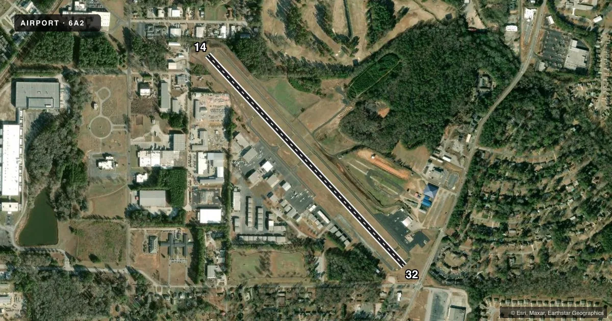
Airport sketch
Runways drawn to scale from FAA survey coordinates, rendered over satellite imagery. Not for navigation.
Approaches & charts
Services on the field
Fuel grades, oxygen, maintenance, ramp storage and lighting — as declared to the FAA by the airport operator.
Fuel & services
- Fuel
- 100LLA+
- Oxygen (bottled)
- Not available
- Oxygen (bulk)
- Not available
- Airframe repair
- Major
- Power plant repair
- Major
- Other services
- AMB,AVNCS,INSTR,RNTL
Ramp & ground
- Transient storage
- Tie-down
- Landing fee
- No fee published
- Customs
- Not available
- Lighting schedule
- SEE RMK
- Beacon schedule
- SS-SR
- Beacon
- White / Green (civil land)(WG)
- Wind indicator
- Lighted
- Segmented circle
- No
Fuel & FBOs
Cheapest 100LL and Jet A on the field and nearby. Always confirm with the FBO before taxi.
Airport notes
Surface conditions, obstructions, local procedures, lighting outages and other notes published with each FAA cycle.
General notes
- FOR CD CTC ATLANTA APCH ON 128.575/343.675 OR 678-364-6131.
Lighting notes
- ACVT REIL RWY 14 & 32; MIRL RWY 14/32 PRESET LOW INTST DUSK TO DAWN; TO INCR INTST - CTAF.
Fuel notes
- 100LL24 HR SELF-SVC FUEL AVBL.
Approach & departure obstructions
- 14RWY 14 12:1 TO DSPLCD THLD.
- 32RWY 32 16:1 TO DSPLCD THLD.
Other notes
- EXISTED PRIOR TO 1959.
VFR map & nearby airports
VFR sectional. Tap any ICAO chip to open that airport.
Key facts · 6A2
Answer card- ICAO
- 6A2
- Name
- GRIFFIN-SPALDING COUNTY
- Location
- GRIFFIN, GEORGIA
- Elevation
- 958.4 ft MSL
- Traffic pattern altitude
- 1,800.4 ft MSL (842 AGL)
- Control tower
- Non-towered (use CTAF)
- Total runways
- 1
- Longest runway
- 14/32 · 3,701 ft
- Published ILS approaches
- 0
- Published frequencies
- 6
- Magnetic variation
- 4°
- Current flight rules
- MVFR
- Current wind
- 300° at 3 kt
- Favored runway now
- RWY 32
Griffin-Spalding County Airport sits in Griffin, Georgia. Field elevation is 958.4 ft MSL. The airport has one runway. Runway 14/32 is 3,701 ft long with an asphalt surface. There is no control tower. Pattern altitude is 842 ft AGL, which is 1,800.4 ft MSL.
No ILS approaches are published here. If you need current approach or clearance details, use Atlanta Approach on 128.575 or 343.675, or call the airport contact listed in the Chart Supplement. The field uses magnetic runway headings of 137° for Runway 14 and 317° for Runway 32. Published remarks note obstacle clearance slopes to the displaced thresholds on both runway ends. That matters on short final, especially if you are planning a steeper or heavier arrival.
The on-field FBO is Griffin-Spalding County Airport. It carries AVGAS 100LL and Jet A Prist. Published remarks also note 24-hour self-service 100LL fuel. Runway end identifier lights are installed on 14 and 32. The medium intensity runway lights are preset to low intensity from dusk to dawn. Use the CTAF if you need to increase intensity.
For a first-time visit, plan for an uncontrolled field with Atlanta Approach support for clearance delivery. Check the current Chart Supplement for any additional local procedures before you go.