METAR & TAF KFFC
Current METAR
Observed 22:53Z
KFFC 262253Z AUTO 26003KT 10SM CLR 31/24 A2992 RMK AO2 SLP125 T03110239 $
- Wind
- 260° @ 3 kt
- Visibility
- 10 SM
- Temp / Dew
- 31°C / 24°C
- Altimeter
- 29.92 inHg
- Clouds
- CLR
- Density alt
- 2,922 ft
- Ceiling
- Unlimited
- Rules
- VFR
Airport info & contacts
Manager on record, flight service, ARTCC, attendance schedule and pattern altitude — published by the FAA and refreshed every 28 days.
Location
- From city
- 25 NM SW
- VFR sectional
- ATLANTA
- ARTCC
- ZTL · ATLANTA
- NOTAM facility
- FFC (NOTAM-D)
Airport manager
- Name
- HOPE MACALUSO
- Phone
- 770-487-2225
- Address
- 7 FALCON DRIVE, PEACHTREE CITY GA 30269
Flight service · Hours
- FSS MCN
- MACON1-800-WX-BRIEF
- Attendance
- 0700-2000
- DECEMBER · 25 · CLSD
- DECEMBER · 24 · 0700-1200
Frequencies
Tap any row to copy the frequency to your clipboard.
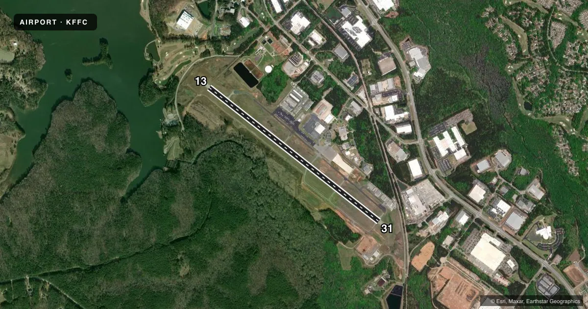
Runways & pattern
Full pagePattern entry · RWY 31
LEFT TRAFFICRunway end performance
| End | TORA | TODA | ASDA | LDA | VGSI | Approach lights | Obstruction |
|---|---|---|---|---|---|---|---|
| 13 | 5,768' | 5,768' | 5,174' | 4,625' | PAPI 4-box left(3.5°) | — | 91', trees, 750' from thr, 517' R of cntrln, slope 6 |
| 31 | 5,768' | 5,768' | 5,318' | 5,118' | PAPI 4-box left(3°) | ODALS | 23', rr, 432' from thr, 534' R of cntrln, slope 10 |
Declared distances in feet. TORA = takeoff run available, TODA = takeoff distance, ASDA = accelerate-stop, LDA = landing distance.
Airport sketch
Runways drawn to scale from FAA survey coordinates, rendered over satellite imagery. Not for navigation.
Approaches & charts
ILS · 1
Services on the field
Fuel grades, oxygen, maintenance, ramp storage and lighting — as declared to the FAA by the airport operator.
Fuel & services
- Fuel
- 100LLA+
- Oxygen (bottled)
- Not available
- Oxygen (bulk)
- Low pressure
- Airframe repair
- Major
- Power plant repair
- Major
- Other services
- AVNCS,CHTR,INSTR,RNTL,SALES,SURV
Ramp & ground
- Transient storage
- Tie-down
- Hangar
- Landing fee
- No fee published
- Lighting schedule
- SEE RMK
- Beacon schedule
- SS-SR
- Beacon
- White / Green (civil land)(WG)
- Wind indicator
- Lighted
- Segmented circle
- Yes
Fuel & FBOs
Cheapest 100LL and Jet A on the field and nearby. Always confirm with the FBO before taxi.
Airport notes
Surface conditions, obstructions, local procedures, lighting outages and other notes published with each FAA cycle.
General notes
- DEER ON AND INVOF OF ARPT.
- ARPT MOWING IN PROG SPRING THRU AUTUMN.
- PERIODIC CRANE OPS INVOF ARPT
- FOR CD CTC ATLANTA APCH AT 678-364-6131.
- BIRD ACT INCL GEESE INVOF ARPT
- BE ALERT: FRQ FLT TRG IN AREA.
- NO AP LDG FEES
- THANKSGIVING FIXED BASED OPR OPN 0700-1200
Lighting notes
- MIRL RWY 13/31 PRESET LOW INTST DUSK-2200; TO INCR INTST & ACTVT AFTER 2200 - CTAF. ACTVT ODALS RWY 31; PAPI RWYS 13 & 31; REIL RWY 13 - CTAF.
Runway surface & condition
- 13/31PCR VALUE: 324/F/D/X/T
Approach & departure obstructions
- 13APCH SLP TO DSPLCD THLD 20:1.
- 31APCH SLP TO DSPLCD THLD 20:1.
VFR map & nearby airports
VFR sectional. Tap any ICAO chip to open that airport.
Key facts · KFFC
Answer card- ICAO
- KFFC
- Name
- ATLANTA RGNL FALCON FLD
- Location
- ATLANTA, GEORGIA
- Elevation
- 807.7 ft MSL
- Traffic pattern altitude
- 1,807.7 ft MSL (1,000 AGL)
- Control tower
- Non-towered (use CTAF)
- Total runways
- 1
- Longest runway
- 13/31 · 5,768 ft
- Published ILS approaches
- 1
- Published frequencies
- 5
- Magnetic variation
- 5°
- Current flight rules
- VFR
- Current wind
- 260° at 3 kt
- Favored runway now
- RWY 31
Atlanta Regional Falcon Field is in Atlanta, Georgia. Field elevation is 807.7 ft MSL. The airport has one runway, 13/31, which is 5,768 ft long. It is not towered. Pattern altitude is not published. Use the standard 1,000 ft AGL pattern for light piston traffic unless the current Chart Supplement says otherwise. The field has one ILS approach to runway 31. Magnetic variation is 5°.
Atlanta Regional Airport is the on-field FBO. It carries AVGAS 100LL and JET A. Call ahead at (770) 487-2225 if you need current ramp or fuel details. Published remarks call out frequent flight training in the area. Expect periodic crane work nearby. Bird activity includes geese. Deer can be on or near the airport. Mowing can also be active from spring through autumn.
Lighting is worth brief planning. The runway lights on 13/31 are preset to low intensity from dusk to 2200. After 2200, use CTAF to increase intensity and activate the lights. Runway 31 has an omnidirectional approach lighting system. Runways 13 and 31 have PAPI. Runway 13 also has REIL. The airport has no landing fees. For clearance delivery, contact Atlanta Approach at 678-364-6131. First-time arrivals should also verify current airspace, noise and any local procedures with the current FAA Chart Supplement before flight.