METAR & TAF KFTY
Current METAR
Observed 08:53Z
KFTY 270853Z 00000KT 10SM CLR 25/24 A2991 RMK AO2 SLP116 T02500239 55013
- Wind
- 000° @ 0 kt
- Visibility
- 10 SM
- Temp / Dew
- 25°C / 24°C
- Altimeter
- 29.91 inHg
- Clouds
- CLR
- Density alt
- 2,255 ft
- Ceiling
- Unlimited
- Rules
- VFR
Airport info & contacts
Manager on record, flight service, ARTCC, attendance schedule and pattern altitude — published by the FAA and refreshed every 28 days.
Location
- From city
- 6 NM W
- VFR sectional
- ATLANTA
- ARTCC
- ZTL · ATLANTA
- NOTAM facility
- FTY (NOTAM-D)
Airport manager
- Name
- GARY HUDSON
- Phone
- 404-613-4205
- Address
- 3977 AVIATION CIRCLE, ATLANTA GA 30336
Flight service · Hours
- FSS MCN
- MACON1-800-WX-BRIEF
- Attendance
- ALL
Frequencies
Tap any row to copy the frequency to your clipboard.
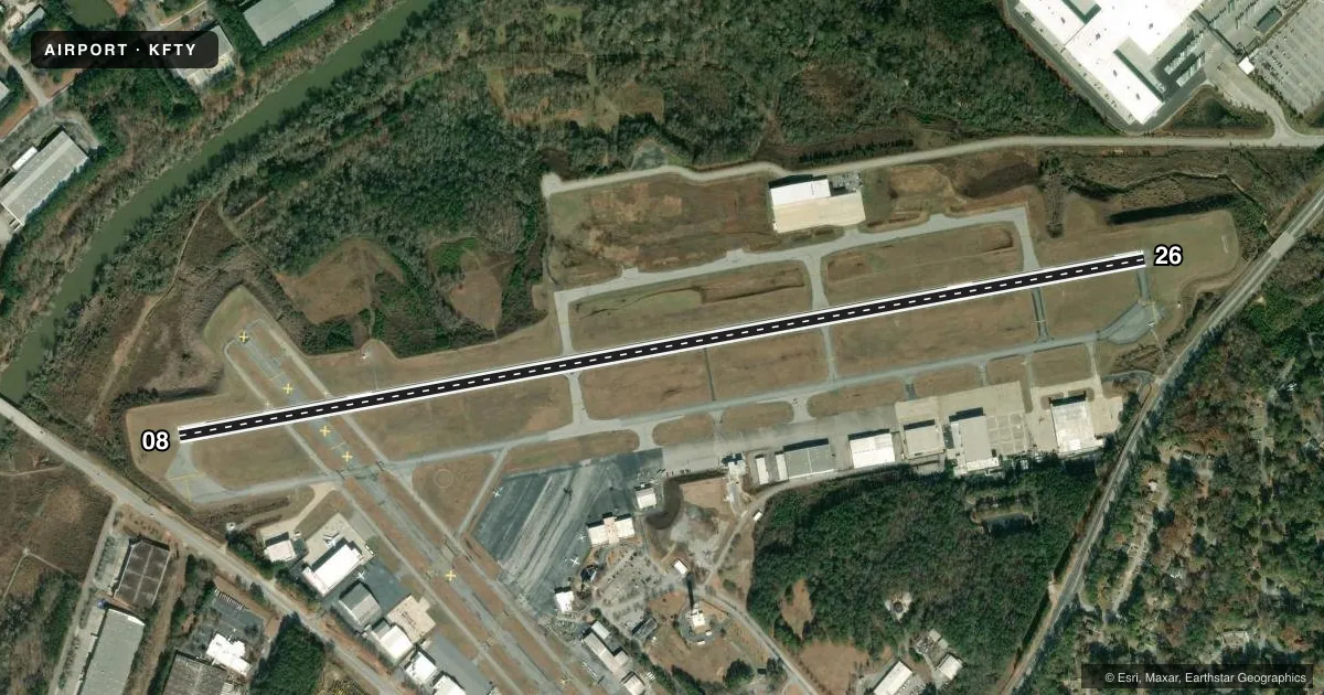
Runways & pattern
Full pagePattern entry · RWY 08
LEFT TRAFFICRunway end performance
| End | TORA | TODA | ASDA | LDA | VGSI | Approach lights | Obstruction |
|---|---|---|---|---|---|---|---|
| 08 | — | — | — | — | — | MALSR | 75', trees, 1475' from thr, 680' R of cntrln, slope 17 |
| 26 | — | — | — | — | VASI 4-box left(3°) | — | 4', trees, 276' from thr, 509' R of cntrln, slope 19 |
Declared distances in feet. TORA = takeoff run available, TODA = takeoff distance, ASDA = accelerate-stop, LDA = landing distance.
Airport sketch
Runways drawn to scale from FAA survey coordinates, rendered over satellite imagery. Not for navigation.
Approaches & charts
ILS · 1
Services on the field
Fuel grades, oxygen, maintenance, ramp storage and lighting — as declared to the FAA by the airport operator.
Fuel & services
- Fuel
- 100LLA+
- Oxygen (bottled)
- HIGH/LOW
- Oxygen (bulk)
- HIGH/LOW
- Airframe repair
- Major
- Power plant repair
- Major
- Other services
- AFRT,AMB,AVNCS,CARGO,CHTR,INSTR,RNTL
Ramp & ground
- Transient storage
- Tie-down
- Hangar
- Landing fee
- No fee published
- Customs
- Not available
- Lighting schedule
- SS-SR
- Beacon schedule
- SS-SR
- Beacon
- White / Green (civil land)(WG)
- Wind indicator
- Yes
- Segmented circle
- Yes
Fuel & FBOs
Cheapest 100LL and Jet A on the field and nearby. Always confirm with the FBO before taxi.
Airport notes
Surface conditions, obstructions, local procedures, lighting outages and other notes published with each FAA cycle.
General notes
- FLOCKS OF BIRDS ON AND INVOF ARPT DURING DALGT HRS.
- NOISE SENSITIVE AREA ALL QUADS; NO RUN UPS AUTH ON ANY RAMPS.
- DEER AND OTHER WILDLIFE ON & INVOF ARPT.
Fuel notes
- 100LLFUEL SVC HILL AVN, C404-691-3330.
Other notes
- EXISTED PRIOR TO 1959.
VFR map & nearby airports
VFR sectional. Tap any ICAO chip to open that airport.
Key facts · KFTY
Answer card- ICAO
- KFTY
- Name
- FULTON COUNTY EXEC/CHARLIE BROWN FLD
- Location
- ATLANTA, GEORGIA
- Elevation
- 841.1 ft MSL
- Traffic pattern altitude
- 1,841.1 ft MSL (1,000 AGL)
- Control tower
- Towered · 24
- Total runways
- 1
- Longest runway
- 08/26 · 5,797 ft
- Published ILS approaches
- 1
- Published frequencies
- 9
- Magnetic variation
- 5°
- Current flight rules
- VFR
- Current wind
- 000° at 0 kt
- Favored runway now
- –
Fulton County Exec/Charlie Brown Fld is in Atlanta, Georgia. The field elevation is 841.1 ft MSL. It has one runway, 08/26, which is 5,797 ft long. The tower is open 24 hours. There is one ILS approach, published for runway 08.
The pattern altitude is not published in the facts block. Use the current FAA Chart Supplement before flight and confirm the pattern entry you plan to use. For a light piston, the usual starting point is 1,000 ft AGL unless published otherwise. The airport sits in a noise sensitive area. No run-ups are authorized on any ramps. That matters here.
On the field, Signature Aviation carries 100LL and Jet A. Hill Aircraft & Leasing carries 100LL, Jet A and Jet A Prist. Fuel service is also noted for Hill Aviation in the published remarks. Deer and birds are reported on and near the airport during daylight hours. Keep a sharp scan on taxi, takeoff and landing. If you are new to the field, plan for a busy controlled airport inside the Atlanta area. Verify current procedures with ATC before arrival.