METAR & TAF 5A2
5A2 does not publish a METAR.
Showing the nearest reporting station: KPXE (PERRY-HOUSTON COUNTY) · 5.5 NM away. Conditions at 5A2 may differ.
METAR · KPXE
Observed 11:55Z
KPXE 271155Z AUTO 30004KT 7SM CLR 26/25 A2992 RMK AO2
- Wind
- 300° @ 4 kt
- Visibility
- 7 SM
- Temp / Dew
- 26°C / 25°C
- Altimeter
- 29.92 inHg
- Clouds
- CLR
- Density alt
- 1,827 ft
- Ceiling
- Unlimited
- Rules
- VFR
Airport info & contacts
Manager on record, flight service, ARTCC, attendance schedule and pattern altitude — published by the FAA and refreshed every 28 days.
Location
- From city
- 4 NM SW
- VFR sectional
- ATLANTA
- ARTCC
- ZTL · ATLANTA
- NOTAM facility
- MCN (NOTAM-D)
Airport manager
- Name
- RODNEY BOGUE
- Phone
- 478-929-0302
- Address
- 123 AIR PARK DRIVE, WARNER ROBINS GA 31088
Flight service · Hours
- FSS MCN
- MACON1-800-WX-BRIEF
- Attendance
- UNATTENDED
Frequencies
Tap any row to copy the frequency to your clipboard.
Runways & pattern
Full pagePattern entry · RWY 27
LEFT TRAFFICRunway end performance
| End | TORA | TODA | ASDA | LDA | VGSI | Approach lights | Obstruction |
|---|---|---|---|---|---|---|---|
| 09 | — | — | — | — | — | — | 48', tree, 192' from thr, 75' R of cntrln, slope 4 |
| 27 | — | — | — | — | — | — | 15', road, 55' from thr, 0' R of cntrln, slope 3 |
Declared distances in feet. TORA = takeoff run available, TODA = takeoff distance, ASDA = accelerate-stop, LDA = landing distance.
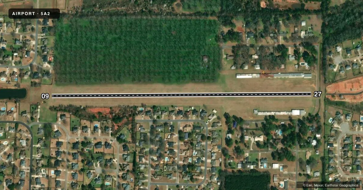
Airport sketch
Runways drawn to scale from FAA survey coordinates, rendered over satellite imagery. Not for navigation.
Approaches & charts
Services on the field
Fuel grades, oxygen, maintenance, ramp storage and lighting — as declared to the FAA by the airport operator.
Fuel & services
- Fuel
- Not available
- Oxygen (bottled)
- Not available
- Oxygen (bulk)
- Not available
- Airframe repair
- Not available
- Power plant repair
- Not available
Ramp & ground
- Transient storage
- Tie-down
- Landing fee
- No fee published
- Lighting schedule
- SEE RMK
- Wind indicator
- Yes
- Segmented circle
- No
Fuel & FBOs
Cheapest 100LL and Jet A on the field and nearby. Always confirm with the FBO before taxi.
Airport notes
Surface conditions, obstructions, local procedures, lighting outages and other notes published with each FAA cycle.
General notes
- FOR CD CTC ATLANTA APCH AT 678-364-6132, WHEN APCH CLSD CTC ATLANTA ARTCC AT 770-210-7692.
Lighting notes
- ACTVT LIRL RY 09/27 - CTAF.
Runway surface & condition
- 09/27MIX OF BLINKING LED SOLAR LIGHTS AND REMAINING LIRL
Approach & departure obstructions
- 27RY 27 DSPLCD THLD MKD WITH LGTS .
- 27APCH RATIO 10:1 TO DSPLCD THLD.
Other notes
- PRVDD ALL OPNS CONDUCTED IN VFR WX CONDS.
VFR map & nearby airports
VFR sectional. Tap any ICAO chip to open that airport.
Key facts · 5A2
Answer card- ICAO
- 5A2
- Name
- WARNER ROBINS AIR PARK
- Location
- WARNER ROBINS, GEORGIA
- Elevation
- 409 ft MSL
- Traffic pattern altitude
- 1,409 ft MSL (1,000 AGL)
- Control tower
- Non-towered (use CTAF)
- Total runways
- 1
- Longest runway
- 09/27 · 2,833 ft
- Published ILS approaches
- 0
- Published frequencies
- 1
- Magnetic variation
- 2°
- Current flight rules
- VFR
- Current wind
- 300° at 4 kt
- Favored runway now
- RWY 27
Warner Robins Air Park sits in Warner Robins, Georgia. Field elevation is 409 ft MSL. The airport has one runway. Runway 09/27 is 2,833 ft long and turf. No control tower is published, so this is a non-towered field on CTAF 122.9. No ILS approaches are published here.
The pattern altitude is not published. Use the standard 1,000 ft AGL pattern for light piston operations unless the current Chart Supplement says otherwise. With a field elevation of 409 ft MSL, that puts the usual light aircraft pattern near 1,409 ft MSL. Runway 09/27 lighting is a mix of blinking LED solar lights and remaining low intensity runway lights. The low intensity lights are activated by CTAF. Runway 27 also has a displaced threshold marked with lights. The published remarks say operations are for VFR weather conditions only. That matters here.
There are no on-field FBOs listed in the facts. Contact the airport operator directly before arrival if you need current services. For clearance delivery, the published remarks direct pilots to Atlanta Approach at 678-364-6132. When Atlanta Approach is closed, contact Atlanta ARTCC at 770-210-7692. The runway is short and turf. Plan for soft-field technique. Verify field condition. Check the current Chart Supplement for any local restrictions before you go.