METAR & TAF KRMG
Current METAR
Observed 09:53Z
KRMG 270953Z AUTO 29003KT 4SM BR FEW004 SCT110 25/24 A2989 RMK AO2 RAB15E39 TSB09E24 SLP110 P0001 T02500244 $
- Wind
- 290° @ 3 kt
- Visibility
- 4 SM
- Temp / Dew
- 25°C / 24°C
- Altimeter
- 29.89 inHg
- Clouds
- SCT
- Density alt
- 2,036 ft
- Ceiling
- Unlimited
- Rules
- MVFR
Airport info & contacts
Manager on record, flight service, ARTCC, attendance schedule and pattern altitude — published by the FAA and refreshed every 28 days.
Location
- From city
- 6 NM N
- VFR sectional
- ATLANTA
- ARTCC
- ZTL · ATLANTA
- NOTAM facility
- RMG (NOTAM-D)
Airport manager
- Name
- JOHN CARROLL
- Phone
- 706-295-7835
- Address
- 304 RUSSELL FIELD RD NE, ROME GA 30161
Flight service · Hours
- FSS MCN
- MACON1-800-WX-BRIEF
- Attendance
- MON-FRI · 0700-2000
- SAT-SUN · 0900-1800
Frequencies
Tap any row to copy the frequency to your clipboard.
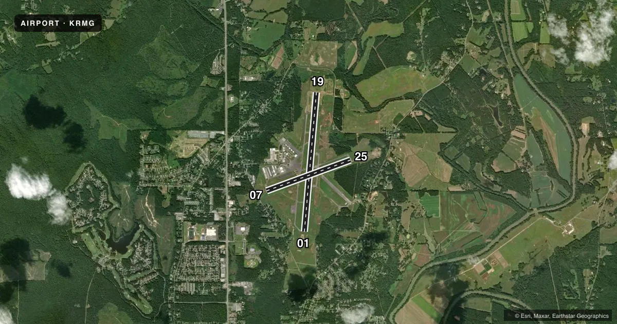
Runways & pattern
Full pagePattern entry · RWY 25
LEFT TRAFFIC| Runway | Heading (°M) | Length | Surface | Traffic |
|---|---|---|---|---|
| 01/19 | 3° / 183° | 7,007 ft | ASPH | Standard L |
| 07/25Favored | 68° / 248° | 4,495 ft | ASPH | Standard L |
Runway end performance
| End | TORA | TODA | ASDA | LDA | VGSI | Approach lights | Obstruction |
|---|---|---|---|---|---|---|---|
| 01 | 7,007' | 7,007' | 7,007' | 7,007' | PAPI 4-box left(3°) | MALSR | 106', trees, 2867' from thr, 666' R of cntrln, slope 25 |
| 19 | 7,007' | 7,007' | 7,007' | 7,007' | PAPI 4-box left(3°) | — | 136', trees, 4562' from thr, 340' R of cntrln, slope 32 |
| 07 | 4,495' | 4,495' | 4,495' | 4,381' | — | — | 15', road, 260' from thr, 300' R of cntrln, slope 4 |
| 25 | 4,495' | 4,495' | 4,495' | 4,495' | — | — | 51', tree, 975' from thr, 361' R of cntrln, slope 15 |
Declared distances in feet. TORA = takeoff run available, TODA = takeoff distance, ASDA = accelerate-stop, LDA = landing distance.
Airport sketch
Runways drawn to scale from FAA survey coordinates, rendered over satellite imagery. Not for navigation.
Approaches & charts
ILS · 1
Services on the field
Fuel grades, oxygen, maintenance, ramp storage and lighting — as declared to the FAA by the airport operator.
Fuel & services
- Fuel
- 100LLA+
- Oxygen (bottled)
- Not available
- Oxygen (bulk)
- Not available
- Airframe repair
- Major
- Power plant repair
- Major
- Other services
- INSTR,RNTL
Ramp & ground
- Transient storage
- Tie-down
- Landing fee
- No fee published
- Customs
- Not available
- Lighting schedule
- SEE RMK
- Beacon schedule
- SS-SR
- Beacon
- White / Green (civil land)(WG)
- Wind indicator
- Lighted
- Segmented circle
- Yes
Fuel & FBOs
Cheapest 100LL and Jet A on the field and nearby. Always confirm with the FBO before taxi.
Airport notes
Surface conditions, obstructions, local procedures, lighting outages and other notes published with each FAA cycle.
General notes
- ULTRALIGHT ACTIVITY ON & INVOF ARPT.
- DEER ON INVOF ARPT.
- MIL AIR CARGO DROP (C130 ACFT) IN PROGRESS 1830-2030 TUE AND THU AT NE END OF RWY 07/25.
- GCO AVBL ON FREQ 121.725 THRU ATL CLEARANCE DELIVERY.
- FOR CD IF UNA TO CTC ON FSS FREQ, CTC ATLANTA ARTCC AT 770-210-7692.
Lighting notes
- ACTVT MALSR RWY 01; REIL RWY 07 & 25, 19; PAPI RWY 01 & 19; MIRL RWY 07/25; HIRL RWY 01/19 - CTAF.
Approach & departure obstructions
- 07RWY 07 - APCH RATIO 13:1 AT DSPLCD THLD; 67 FT TREES 1071 FT FM DSPLCD THLD 350 FT L.
VFR map & nearby airports
VFR sectional. Tap any ICAO chip to open that airport.
Key facts · KRMG
Answer card- ICAO
- KRMG
- Name
- RICHARD B RUSSELL RGNL - J H TOWERS FLD
- Location
- ROME, GEORGIA
- Elevation
- 644 ft MSL
- Traffic pattern altitude
- 1,644 ft MSL (1,000 AGL)
- Control tower
- Non-towered (use CTAF)
- Total runways
- 2
- Longest runway
- 01/19 · 7,007 ft
- Published ILS approaches
- 1
- Published frequencies
- 2
- Magnetic variation
- 2°
- Current flight rules
- MVFR
- Current wind
- 290° at 3 kt
- Favored runway now
- RWY 25
Richard B Russell Rgnl - J H Towers Fld is in Rome, Georgia. The field elevation is 644 ft MSL. It has two asphalt runways. The longest is runway 01/19 at 7,010 ft. The airport is non-towered. CTAF and UNICOM are both 122.725. One ILS approach is published for runway 01.
Pattern altitude is not published. Use 1,000 ft AGL for light piston traffic unless the current Chart Supplement says otherwise. The field sits in a busy local environment. Ultralight activity is reported on and near the airport. Deer are also present on and in the vicinity of the field. Military C130 cargo drops have been reported from 1830 to 2030 on Tuesday and Thursday at the northeast end of runway 07/25. That is worth planning around if you are operating nearby.
Lighting is mixed across the field. MALSR is used for runway 01. REIL is available for runways 07, 25 and 19. PAPI is available for runways 01 and 19. Runways 07 and 25 have medium intensity lighting. Runways 01 and 19 have high intensity lighting controlled by CTAF. Floyd County Airport Commission is the on-field FBO. It carries 100LL and Jet A. If you need clearance delivery help and cannot raise flight service, Atlanta ARTCC is listed as a backup contact. Runway 07 has a published displaced-threshold obstacle note with trees near the approach path, so brief that side carefully before arrival.