METAR & TAF 4A9
Current METAR
Observed 10:35Z
K4A9 271035Z AUTO 32003KT 7SM BR SCT100 25/25 A2995 RMK AO2 LTG DSNT S AND SW T02500246
- Wind
- 320° @ 3 kt
- Visibility
- 7 SM
- Temp / Dew
- 25°C / 25°C
- Altimeter
- 29.95 inHg
- Clouds
- SCT
- Density alt
- 2,250 ft
- Ceiling
- Unlimited
- Rules
- VFR
Airport info & contacts
Manager on record, flight service, ARTCC, attendance schedule and pattern altitude — published by the FAA and refreshed every 28 days.
Location
- From city
- 2 NM N
- VFR sectional
- ATLANTA
- ARTCC
- ZTL · ATLANTA
- NOTAM facility
- 4A9 (NOTAM-D)
Airport manager
- Name
- BARRY STONE
- Phone
- 256-845-9129
- Address
- 2200 TERMINAL DRIVE NW, FORT PAYNE AL 35968
Flight service · Hours
- FSS ANB
- ANNISTON1-800-WX-BRIEF
- Attendance
- 0700-1700
Frequencies
Tap any row to copy the frequency to your clipboard.
Runways & pattern
Full pagePattern entry · RWY 04
LEFT TRAFFICRunway end performance
| End | TORA | TODA | ASDA | LDA | VGSI | Approach lights | Obstruction |
|---|---|---|---|---|---|---|---|
| 04 | — | — | — | — | PAPI 4-box left(4°) | — | 62', tree, 1536' from thr, 189' R of cntrln, slope 21 |
| 22 | — | — | — | — | PAPI 4-box right(3°) | — | — |
Declared distances in feet. TORA = takeoff run available, TODA = takeoff distance, ASDA = accelerate-stop, LDA = landing distance.
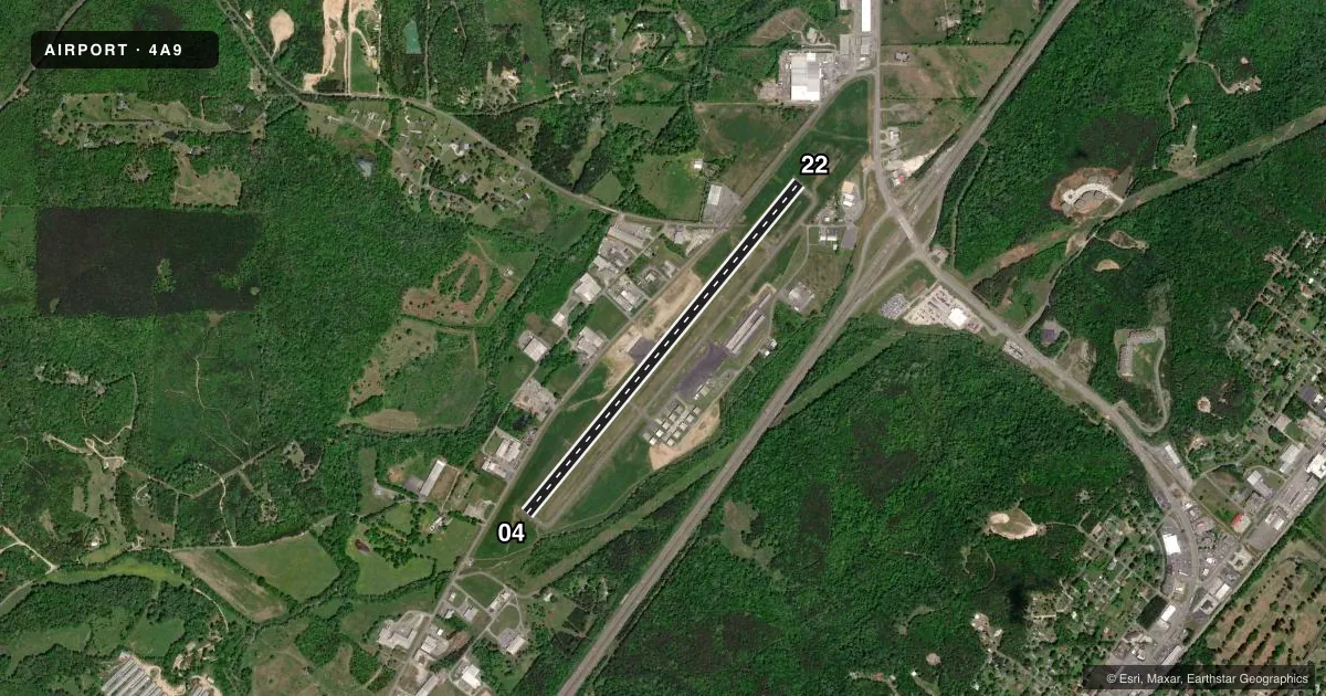
Airport sketch
Runways drawn to scale from FAA survey coordinates, rendered over satellite imagery. Not for navigation.
Approaches & charts
Services on the field
Fuel grades, oxygen, maintenance, ramp storage and lighting — as declared to the FAA by the airport operator.
Fuel & services
- Fuel
- 100LLA+
- Other services
- INSTR,RNTL
Ramp & ground
- Transient storage
- Tie-down
- Landing fee
- No fee published
- Customs
- Not available
- Lighting schedule
- SEE RMK
- Beacon schedule
- SS-SR
- Beacon
- White / Green (civil land)(WG)
- Wind indicator
- Lighted
- Segmented circle
- No
Fuel & FBOs
Cheapest 100LL and Jet A on the field and nearby. Always confirm with the FBO before taxi.
Airport notes
Surface conditions, obstructions, local procedures, lighting outages and other notes published with each FAA cycle.
General notes
- FOR CD CTC ATLANTA ARTCC AT 770-210-7692.
Lighting notes
- MIRL RWY 4/22 PRESET LOW INTST, TO INCR INTST ACTVT - CTAF. REIL RWY 04 & 22 ACTVT - CTAF. PAPI RWYS 04 & 22 OPR CONSLY.
Other notes
- PRIOR TO FAA ACT.
- 1FOR SVC AFT HRS CALL 256-997-7524.
VFR map & nearby airports
VFR sectional. Tap any ICAO chip to open that airport.
Key facts · 4A9
Answer card- ICAO
- 4A9
- Name
- ISBELL FLD
- Location
- FORT PAYNE, ALABAMA
- Elevation
- 876.7 ft MSL
- Traffic pattern altitude
- 1,876.7 ft MSL (1,000 AGL)
- Control tower
- Non-towered (use CTAF)
- Total runways
- 1
- Longest runway
- 04/22 · 5,001 ft
- Published ILS approaches
- 0
- Published frequencies
- 2
- Magnetic variation
- 4°
- Current flight rules
- VFR
- Current wind
- 320° at 3 kt
- Favored runway now
- RWY 04
Isbell Fld sits in Fort Payne, Alabama. The field elevation is 876.7 ft MSL. It has one runway, 04/22, which is 5,001 ft long and asphalt. The airport is non-towered. CTAF and UNICOM are both 122.8. No ILS approaches are published here.
The pattern altitude is not published, so plan on the standard 1,000 ft AGL for light piston traffic unless the current Chart Supplement says otherwise. The on-field FBO is Fort Payne Airport. It carries 100LL and Jet A. Call ahead if you need after-hours service. The published remarks also note that runway 04/22 lighting is preset to low intensity. You can increase it by keying the CTAF. REILs on both runway ends also activate on CTAF. PAPI on 04 and 22 operate continuously.
For a first-time arrival, the main things to have dialed in are the non-towered pattern work, the runway lighting setup and the lack of published ILS guidance. If you need clearance delivery, the Chart Supplement lists Atlanta ARTCC at 770-210-7692. Check current runway and airspace details before departure, especially if you are planning a night arrival or IFR flight.