METAR & TAF KBFZ
Current METAR
Observed 09:55Z
KBFZ 270955Z AUTO 32006KT 9SM FEW085 26/26 A2996 RMK AO2 LTG DSNT SE AND W
- Wind
- 320° @ 6 kt
- Visibility
- 9 SM
- Temp / Dew
- 26°C / 26°C
- Altimeter
- 29.96 inHg
- Clouds
- FEW
- Density alt
- 2,550 ft
- Ceiling
- Unlimited
- Rules
- VFR
Airport info & contacts
Manager on record, flight service, ARTCC, attendance schedule and pattern altitude — published by the FAA and refreshed every 28 days.
Location
- From city
- 3 NM SW
- VFR sectional
- ATLANTA
- ARTCC
- ZTL · ATLANTA
- NOTAM facility
- BFZ (NOTAM-D)
Airport manager
- Name
- MARK CHESNUT
- Phone
- 256-960-9012
- Address
- P. O. BOX 1248, ALBERTVILLE AL 35950
Flight service · Hours
- FSS ANB
- ANNISTON1-800-WX-BRIEF
- Attendance
- MON-SAT · 0700-DUSK
- SUN · 1230-DUSK
Frequencies
Tap any row to copy the frequency to your clipboard.
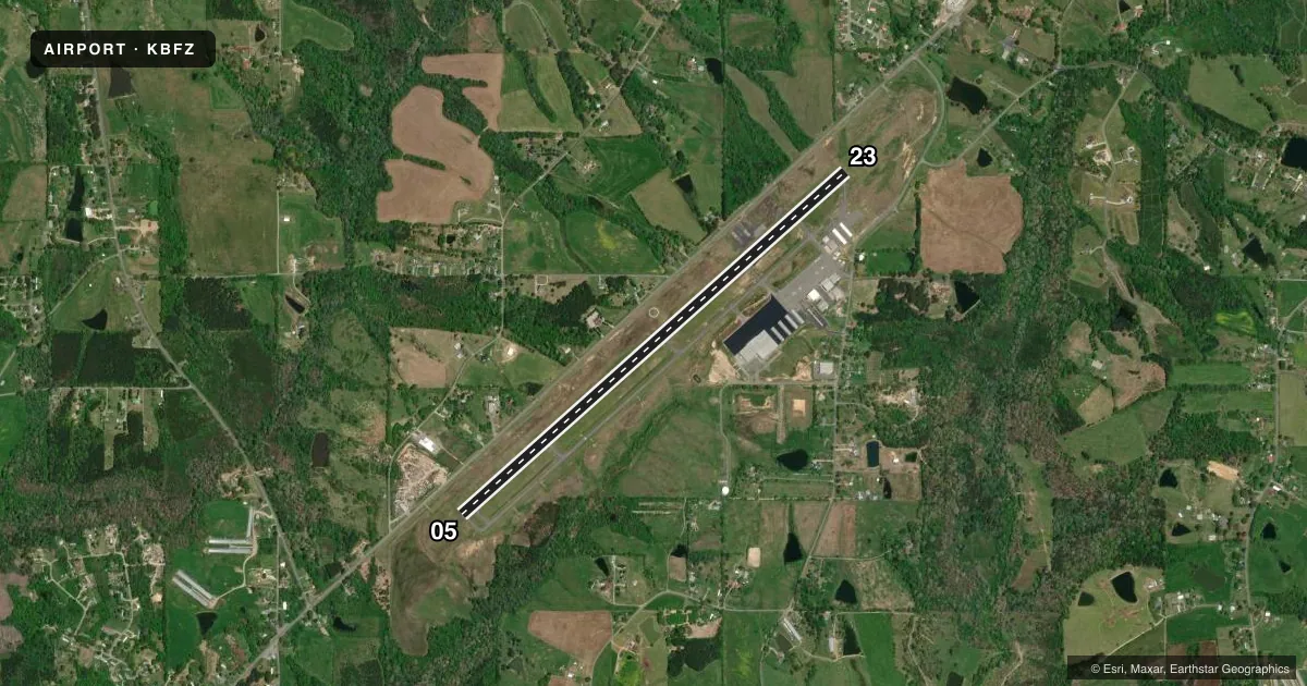
Runways & pattern
Full pagePattern entry · RWY 05
LEFT TRAFFICRunway end performance
| End | TORA | TODA | ASDA | LDA | VGSI | Approach lights | Obstruction |
|---|---|---|---|---|---|---|---|
| 05 | — | — | — | — | PAPI 2-box left(3°) | — | 40', trees, 1414' from thr, 178' R of cntrln, slope 30 |
| 23 | — | — | — | — | PAPI 2-box left(3°) | — | 58', trees, 2046' from thr, 329' R of cntrln, slope 31 |
Declared distances in feet. TORA = takeoff run available, TODA = takeoff distance, ASDA = accelerate-stop, LDA = landing distance.
Airport sketch
Runways drawn to scale from FAA survey coordinates, rendered over satellite imagery. Not for navigation.
Approaches & charts
Services on the field
Fuel grades, oxygen, maintenance, ramp storage and lighting — as declared to the FAA by the airport operator.
Fuel & services
- Fuel
- 100LLA+
- Oxygen (bottled)
- HIGH/LOW
- Airframe repair
- Major
- Power plant repair
- Major
- Other services
- INSTR,RNTL
Ramp & ground
- Transient storage
- Tie-down
- Landing fee
- No fee published
- Customs
- Not available
- Lighting schedule
- SEE RMK
- Beacon schedule
- SS-SR
- Beacon
- White / Green (civil land)(WG)
- Wind indicator
- Lighted
- Segmented circle
- Yes
Fuel & FBOs
Cheapest 100LL and Jet A on the field and nearby. Always confirm with the FBO before taxi.
Airport notes
Surface conditions, obstructions, local procedures, lighting outages and other notes published with each FAA cycle.
General notes
- FOR CD CTC BIRMINGHAM APCH AT 205-769-3890.
Lighting notes
- DUSK - 2300. MIRL RWY 05/23 PRESET MED INTST DUSK-2300; TO INCR INTST - CTAF. AFT 2300 ACTVT REIL RWY 23; PAPI RWYS 05 & 23; MIRL RWY 05/23 - CTAF.
Runway surface & condition
- 05/23PCR VALUE: 401/F/D/X/T
Other notes
- MANAGERAFT HRS 256-302-6082 OR 256-302-7886.
VFR map & nearby airports
VFR sectional. Tap any ICAO chip to open that airport.
Key facts · KBFZ
Answer card- ICAO
- KBFZ
- Name
- ALBERTVILLE RGNL/THOMAS J BRUMLIK FLD
- Location
- ALBERTVILLE, ALABAMA
- Elevation
- 1,032.3 ft MSL
- Traffic pattern altitude
- 2,032.3 ft MSL (1,000 AGL)
- Control tower
- Non-towered (use CTAF)
- Total runways
- 1
- Longest runway
- 05/23 · 6,114 ft
- Published ILS approaches
- 0
- Published frequencies
- 4
- Magnetic variation
- 2°
- Current flight rules
- VFR
- Current wind
- 320° at 6 kt
- Favored runway now
- RWY 05
Albertville Rgnl/Thomas J Brumlik Fld sits in Albertville, Alabama. Field elevation is 1,032.3 ft MSL. The airport has one runway. Runway 05/23 is 6,114 ft long with asphalt pavement. That is the longest runway on the field.
This is a non-towered airport. CTAF and UNICOM are both 123.0. Approach and departure services are handled by Birmingham on 125.45 and 279.65. No ILS approaches are published here, so plan with current charts and weather in mind before you go.
Pattern altitude is not published. Use 1,000 ft AGL for light piston operations unless the current Chart Supplement says otherwise. That puts the pattern at about 2,032.3 ft MSL based on the listed field elevation. The runway lighting is pilot-controlled on CTAF. From dusk to 2300, the medium intensity lights are preset. After 2300, runway 23 has runway end identifier lights activated. PAPI is available on both runway ends.
Albertville Aviation is on the field. It carries 100LL and Jet A. For clearance delivery, contact Birmingham Approach at 205-769-3890. After hours, the published manager numbers are 256-302-6082 and 256-302-7886. The pavement classification number is 401/F/D/X/T. Check current runway and lighting details before night or IFR operations.