METAR & TAF 8A1
Current METAR
Observed 05:15Z
K8A1 270515Z AUTO 26001KT 6SM BR CLR 27/27 A2995 RMK AO2 LTG DSNT NW
- Wind
- 260° @ 1 kt
- Visibility
- 6 SM
- Temp / Dew
- 27°C / 27°C
- Altimeter
- 29.95 inHg
- Clouds
- CLR
- Density alt
- 2,165 ft
- Ceiling
- Unlimited
- Rules
- VFR
Airport info & contacts
Manager on record, flight service, ARTCC, attendance schedule and pattern altitude — published by the FAA and refreshed every 28 days.
Location
- From city
- 3 NM NE
- VFR sectional
- ATLANTA
- ARTCC
- ZME · MEMPHIS
- NOTAM facility
- ANB (NOTAM-D)
Airport manager
- Name
- GARY MCILQUHAM
- Phone
- (256) 582-6087
- Address
- 405 BUCK ISLAND RD, GUNTERSVILLE AL 35976
Flight service · Hours
- FSS ANB
- ANNISTON1-800-WX-BRIEF
- Attendance
- MON - SAT · 0800-1700
Frequencies
Tap any row to copy the frequency to your clipboard.
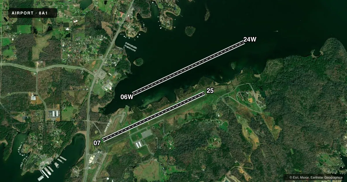
Runways & pattern
Full pagePattern entry · RWY 24W
LEFT TRAFFIC| Runway | Heading (°M) | Length | Surface | Traffic |
|---|---|---|---|---|
| 06W/24WFavored | 61° / 241° | 5,500 ft | WATER | Standard L |
| 07/25 | 61° / 241° | 5,005 ft | ASPH | Standard L |
Runway end performance
| End | TORA | TODA | ASDA | LDA | VGSI | Approach lights | Obstruction |
|---|---|---|---|---|---|---|---|
| 07 | — | — | — | — | — | — | 45', tree, 604' from thr, 290' R of cntrln, slope 8 |
| 25 | — | — | — | — | PAPI 2-box left(3.35°) | — | 21', trees, 248' from thr, 9013' R of cntrln, slope 2 |
Declared distances in feet. TORA = takeoff run available, TODA = takeoff distance, ASDA = accelerate-stop, LDA = landing distance.
Airport sketch
Runways drawn to scale from FAA survey coordinates, rendered over satellite imagery. Not for navigation.
Approaches & charts
Services on the field
Fuel grades, oxygen, maintenance, ramp storage and lighting — as declared to the FAA by the airport operator.
Fuel & services
- Fuel
- 100LLA+
- Oxygen (bottled)
- Not available
- Oxygen (bulk)
- Not available
- Airframe repair
- Major
- Power plant repair
- Major
- Other services
- RNTL
Ramp & ground
- Transient storage
- Tie-down
- Landing fee
- No fee published
- Customs
- Not available
- Lighting schedule
- SEE RMK
- Beacon schedule
- SS-SR
- Beacon
- White / Green (civil land)(WG)
- Wind indicator
- Yes
- Segmented circle
- Yes
Fuel & FBOs
Cheapest 100LL and Jet A on the field and nearby. Always confirm with the FBO before taxi.
Airport notes
Surface conditions, obstructions, local procedures, lighting outages and other notes published with each FAA cycle.
General notes
- DEER, BIRDS, AND COYOTES ON & INVOF ARPT.
- FOR CD CTC HUNTSVILLE APCH AT 256-542-2070, WHEN APCH CLSD CTC MEMPHIS ARTCC AT 901-368-8453/8449.
Lighting notes
- ACTVT REIL RWY 7 & 25; PAPI RWY 25; MIRL RWY 7/25 - CTAF.
Fuel notes
- 100LL24/7 SELF-SVC AVGAS & FULL SVC JET-A DURNG NML OPN HRS.
Other notes
- 2MGR ON CALL AFT HRS.
- 2CALL OUT SVC AVBL 256-582-6087.
VFR map & nearby airports
VFR sectional. Tap any ICAO chip to open that airport.
Key facts · 8A1
Answer card- ICAO
- 8A1
- Name
- GUNTERSVILLE MUNI/JOE STARNES FLD
- Location
- GUNTERSVILLE, ALABAMA
- Elevation
- 614.6 ft MSL
- Traffic pattern altitude
- 1,614.6 ft MSL (1,000 AGL)
- Control tower
- Non-towered (use CTAF)
- Total runways
- 2
- Longest runway
- 06W/24W · 5,500 ft
- Published ILS approaches
- 0
- Published frequencies
- 4
- Magnetic variation
- 4°
- Current flight rules
- VFR
- Current wind
- 260° at 1 kt
- Favored runway now
- RWY 24W
Guntersville Muni/Joe Starnes Fld sits in Guntersville, Alabama. Field elevation is 614.6 ft MSL. The airport has two runways. The longest is 5,500 ft on the water runway 06W/24W. The other runway is 07/25 at 5,005 ft asphalt. There is no control tower. Use CTAF 122.8.
No ILS approaches are published here. Pattern altitude is not published, so a light piston pilot should plan on the standard 1,000 ft AGL unless the current Chart Supplement says otherwise. Published remarks also note runway end identifier lights on 7 and 25. Runway 25 has a PAPI. Medium intensity runway lights are available on 7 and 25. Deer, birds and coyotes are reported on and near the field. Keep a sharp scan on arrival and departure.
Guntersville Municipal Airport is the on-field FBO. It carries 100LL and Jet-A Prist. The published remarks say 24-hour self-service Avgas is available. Full service Jet-A is available during normal operating hours. For clearance delivery, contact Huntsville Approach. If approach is closed, use Memphis ARTCC. This is a non-towered field with mixed water and asphalt operations. Brief the runway surface before you get there and verify current local procedures with the airport operator or the FBO directly by phone.