METAR & TAF KBGF
Current METAR
Observed 04:55Z
KBGF 270455Z AUTO 00000KT 7SM FEW028 SCT036 BKN041 25/25 A2994 RMK A01
- Wind
- 000° @ 0 kt
- Visibility
- 7 SM
- Temp / Dew
- 25°C / 25°C
- Altimeter
- 29.94 inHg
- Clouds
- BKN
- Density alt
- 2,389 ft
- Ceiling
- 4,100 ft AGL
- Rules
- VFR
Airport info & contacts
Manager on record, flight service, ARTCC, attendance schedule and pattern altitude — published by the FAA and refreshed every 28 days.
Location
- From city
- 3 NM SE
- VFR sectional
- ATLANTA
- ARTCC
- ZME · MEMPHIS
- NOTAM facility
- BNA (NOTAM-D)
Airport manager
- Name
- KATELYN SANDERS
- Phone
- 931-967-3148
- Address
- 420 AVIATION DR., WINCHESTER TN 37398
Flight service · Hours
- FSS BNA
- NASHVILLE1-800-WX-BRIEF
- Attendance
- 0800-1800
Frequencies
Tap any row to copy the frequency to your clipboard.
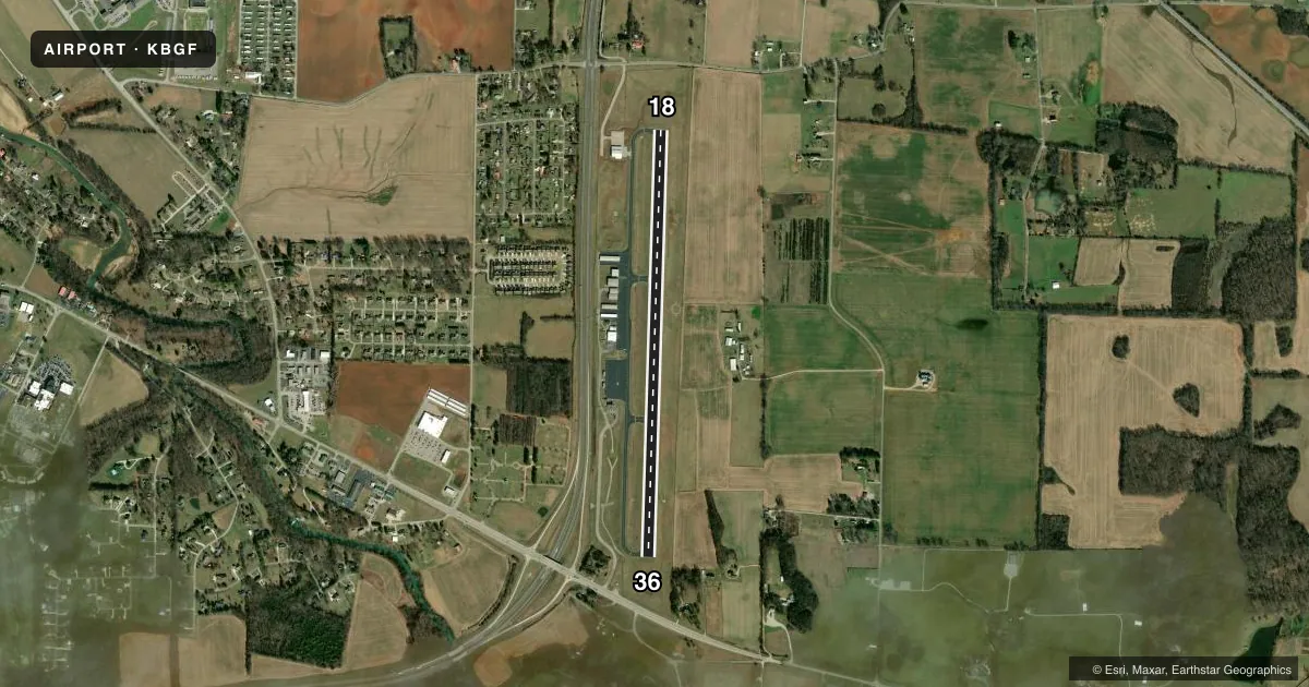
Runways & pattern
Full pagePattern entry · RWY 18
LEFT TRAFFICRunway end performance
| End | TORA | TODA | ASDA | LDA | VGSI | Approach lights | Obstruction |
|---|---|---|---|---|---|---|---|
| 18 | — | — | — | — | PAPI 2-box left(3.5°) | — | 114', trees, 2846' from thr, 71' R of cntrln, slope 24 |
| 36 | — | — | — | — | PAPI 2-box left(3.5°) | — | 47', trees, 1249' from thr, 300' R of cntrln, slope 22 |
Declared distances in feet. TORA = takeoff run available, TODA = takeoff distance, ASDA = accelerate-stop, LDA = landing distance.
Airport sketch
Runways drawn to scale from FAA survey coordinates, rendered over satellite imagery. Not for navigation.
Approaches & charts
Services on the field
Fuel grades, oxygen, maintenance, ramp storage and lighting — as declared to the FAA by the airport operator.
Fuel & services
- Fuel
- 100LLAA+
- Oxygen (bottled)
- Not available
- Oxygen (bulk)
- Not available
- Airframe repair
- Major
- Power plant repair
- Major
- Other services
- CHTR,INSTR,RNTL
Ramp & ground
- Transient storage
- Tie-down
- Hangar
- Landing fee
- No fee published
- Customs
- Not available
- Lighting schedule
- SS-SR
- Beacon schedule
- SS-SR
- Beacon
- White / Green (civil land)(WG)
- Wind indicator
- Lighted
- Segmented circle
- Yes
Fuel & FBOs
Cheapest 100LL and Jet A on the field and nearby. Always confirm with the FBO before taxi.
Airport notes
Surface conditions, obstructions, local procedures, lighting outages and other notes published with each FAA cycle.
General notes
- HEAVY NON-RADIO EQUIPPED TFC FIRST SAT OF EACH MONTH.
- GCO AVBL ON FREQ 121.725; KEY 4 TIMES SLOWLY.
- FOR CD IF UNA VIA GCO CTC MEMPHIS ARTCC AT 901-368-8453/8449.
Other notes
- 1UNATNDD CHRISTMAS; NEW YEARS; LABOR DAY; MEMORIAL DAY; THANKSGIVING.
- 1AFT HR - 931--636-1817.
VFR map & nearby airports
VFR sectional. Tap any ICAO chip to open that airport.
Key facts · KBGF
Answer card- ICAO
- KBGF
- Name
- WINCHESTER MUNI
- Location
- WINCHESTER, TENNESSEE
- Elevation
- 978.8 ft MSL
- Traffic pattern altitude
- 1,978.8 ft MSL (1,000 AGL)
- Control tower
- Non-towered (use CTAF)
- Total runways
- 1
- Longest runway
- 18/36 · 5,003 ft
- Published ILS approaches
- 0
- Published frequencies
- 2
- Magnetic variation
- 3°
- Current flight rules
- VFR
- Current wind
- 000° at 0 kt
- Favored runway now
- –
Winchester Muni sits in Winchester, Tennessee. Field elevation is 978.8 ft MSL. The airport has one runway, 18/36, which is 5,003 ft long. It is a non-towered field. CTAF and UNICOM are both 122.8. No ILS approaches are published here.
The published pattern altitude is not listed. Use the standard 1,000 ft AGL pattern unless local procedures or the current Chart Supplement say otherwise. That puts the light piston pattern at about 1,979 ft MSL based on the field elevation. The runway headings are magnetic. 18 is 182°. 36 is 2°.
Winchester Municipal Airport is the on-field FBO. It carries 100LL, Jet A and Jet A Prist. Call (931) 967-3148 for current service details. The remarks also note a ground communications outlet on 121.725. Key four times slowly if you need to use it. Heavy non-radio traffic can show up on the first Saturday of each month. After hours, use 931-636-1817. The field is unattended on Christmas, New Years, Labor Day, Memorial Day and Thanksgiving. For a first-time arrival, plan for a quiet non-towered airport with standard pattern work. Verify any local procedures before you go.