METAR & TAF KTHA
Current METAR
Observed 12:55Z
KTHA 271255Z AUTO 00000KT 9SM BKN004 OVC008 22/22 A2994 RMK A01
- Wind
- 000° @ 0 kt
- Visibility
- 9 SM
- Temp / Dew
- 22°C / 22°C
- Altimeter
- 29.94 inHg
- Clouds
- OVC
- Density alt
- 2,159 ft
- Ceiling
- 400 ft AGL
- Rules
- LIFR
Airport info & contacts
Manager on record, flight service, ARTCC, attendance schedule and pattern altitude — published by the FAA and refreshed every 28 days.
Location
- From city
- 2 NM NW
- VFR sectional
- ATLANTA
- ARTCC
- ZME · MEMPHIS
- NOTAM facility
- BNA (NOTAM-D)
Airport manager
- Name
- JON GLASS
- Phone
- 931-455-3884
- Address
- P.O. BOX 1584, TULLAHOMA TN 37388
Flight service · Hours
- FSS BNA
- NASHVILLE1-800-WX-BRIEF
- Attendance
- 0800-1800
Frequencies
Tap any row to copy the frequency to your clipboard.
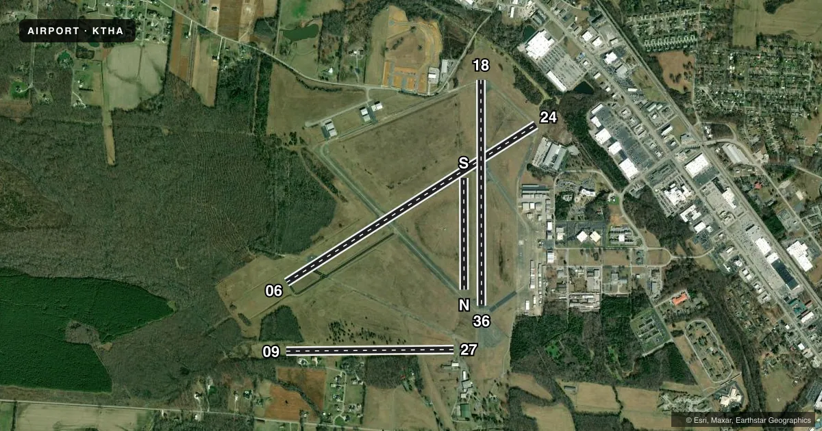
Runways & pattern
Full pagePattern entry · RWY 06
LEFT TRAFFIC| Runway | Heading (°M) | Length | Surface | Traffic |
|---|---|---|---|---|
| 06/24 | 55° / 235° | 5,501 ft | ASPH-CONC | Standard L |
| 18/36 | 177° / 357° | 4,205 ft | ASPH-CONC | Standard L |
| 09/27 | 86° / 266° | 3,130 ft | TURF | 09 R |
| N/S | 357° / 177° | 2,083 ft | TURF | Standard L |
Runway end performance
| End | TORA | TODA | ASDA | LDA | VGSI | Approach lights | Obstruction |
|---|---|---|---|---|---|---|---|
| 06 | — | — | — | — | PAPI 2-box left(3°) | ODALS | 44', tree, 1064' from thr, 181' R of cntrln, slope 19 |
| 24 | — | — | — | — | PAPI 2-box left(3°) | — | 45', tree, 837' from thr, 152' R of cntrln, slope 14 |
| 18 | — | — | — | — | PAPI 2-box left(2.95°) | — | 80', tree, 1555' from thr, 385' R of cntrln, slope 16 |
| 36 | — | — | — | — | PAPI 2-box left(3°) | — | 85', tree, 1359' from thr, 351' R of cntrln, slope 13 |
| 09 | — | — | — | — | — | — | 74', tree, 1322' from thr, 209' R of cntrln, slope 17 |
| 27 | — | — | — | — | — | — | 55', tree, 1040' from thr, 46' R of cntrln, slope 18 |
| N | — | — | — | — | — | — | 92', tree, 2713' from thr, 399' R of cntrln, slope 29 |
| S | — | — | — | — | — | — | 77', tree, 2174' from thr, 373' R of cntrln, slope 28 |
Declared distances in feet. TORA = takeoff run available, TODA = takeoff distance, ASDA = accelerate-stop, LDA = landing distance.
Airport sketch
Runways drawn to scale from FAA survey coordinates, rendered over satellite imagery. Not for navigation.
Approaches & charts
Services on the field
Fuel grades, oxygen, maintenance, ramp storage and lighting — as declared to the FAA by the airport operator.
Fuel & services
- Fuel
- 100A
- Airframe repair
- Major
- Power plant repair
- Major
- Other services
- AMB,AVNCS,CHTR,GLD,INSTR,PAJA,RNTL,TOW
Ramp & ground
- Transient storage
- Tie-down
- Hangar
- Landing fee
- No fee published
- Customs
- Not available
- Lighting schedule
- SEE RMK
- Beacon schedule
- SS-SR
- Beacon
- White / Green (civil land)(WG)
- Wind indicator
- Yes
- Segmented circle
- Yes
Fuel & FBOs
Cheapest 100LL and Jet A on the field and nearby. Always confirm with the FBO before taxi.
Airport notes
Surface conditions, obstructions, local procedures, lighting outages and other notes published with each FAA cycle.
General notes
- PAJA, GLIDER OPS, GEESE & DEER ON & INVOF ARPT; PAJA LNDG ZONE E OF PAVED RWY 18/36 MIDFIELD.
- FOR CD CTC MEMPHIS ARTCC AT 901-368-8453/8449.
Lighting notes
- ACTVT ODALS RWY 06; PAPI RWY 18 & 36; MIRL RWY 18/36 - CTAF. MIRL RWY 06/24 PRESET TO LOW INTST; INCR INTST - CTAF.
Runway surface & condition
- 09/27FICON SOFT SFC WHEN WET.
Approach & departure obstructions
- 2426:1 TO DTHR.
- 3626:1 TO DTHR.
- 18FADED & PEELING.
- 36FADED & PEELING.
- 36UNUSBL BYD 7 DEGS LEFT AND RIGHT OF CNTRLN.
Other notes
- EXISTED PRIOR TO 1959
VFR map & nearby airports
VFR sectional. Tap any ICAO chip to open that airport.
Key facts · KTHA
Answer card- ICAO
- KTHA
- Name
- TULLAHOMA RGNL/WM NORTHERN FLD
- Location
- TULLAHOMA, TENNESSEE
- Elevation
- 1,084 ft MSL
- Traffic pattern altitude
- 2,084 ft MSL (1,000 AGL)
- Control tower
- Non-towered (use CTAF)
- Total runways
- 4
- Longest runway
- 06/24 · 5,501 ft
- Published ILS approaches
- 0
- Published frequencies
- 2
- Magnetic variation
- 3°
- Current flight rules
- LIFR
- Current wind
- 000° at 0 kt
- Favored runway now
- –
Tullahoma Rgnl/WM Northern Fld sits in Tullahoma, Tennessee. Field elevation is 1,084 ft MSL. The airport has four runways. The longest is runway 06/24 at 5,501 ft. There is no control tower. CTAF and UNICOM are both 123.0.
No ILS approaches are published here. Pattern altitude is not published, so use standard 1,000 ft AGL for light piston traffic unless the current FAA Chart Supplement says otherwise. The field is served by the Tullahoma Municipal Airport Authority on the field. They carry 100LL and Jet A. Call (931) 455-3884 for current service details before you go.
A few runway notes matter here. Runway 36 markings are faded and peeling. Runway 18 markings are also faded and peeling. Runway 09/27 has a flexible pavement surface that can be soft when wet. Runway 24 has a 26 to 1 slope to the displaced threshold. Runway 36 has the same slope to its displaced threshold. The airport uses lighting on the paved runways. CTAF controls the medium intensity lights on 18/36. Expect geese, deer, glider activity and painted jet aircraft near the field. For clearance delivery, contact Memphis ARTCC before departure.