METAR & TAF KMBT
Current METAR
Observed 10:35Z
KMBT 271035Z AUTO 18006KT 10SM FEW006 FEW038 SCT048 23/23 A2992 RMK A01
- Wind
- 180° @ 6 kt
- Visibility
- 10 SM
- Temp / Dew
- 23°C / 23°C
- Altimeter
- 29.92 inHg
- Clouds
- SCT
- Density alt
- 1,722 ft
- Ceiling
- Unlimited
- Rules
- VFR
Airport info & contacts
Manager on record, flight service, ARTCC, attendance schedule and pattern altitude — published by the FAA and refreshed every 28 days.
Location
- From city
- 2 NM N
- VFR sectional
- ATLANTA
- ARTCC
- ZME · MEMPHIS
- NOTAM facility
- BNA (NOTAM-D)
Airport manager
- Name
- RYAN HULSEY
- Phone
- 615-217-5048
- Address
- 1930 MEMORIAL BLVD., MURFREESBORO TN 37129
Flight service · Hours
- FSS BNA
- NASHVILLE1-800-WX-BRIEF
- Attendance
- SUN · 0700-1900
- MON-SAT · 0700-1900
Frequencies
Tap any row to copy the frequency to your clipboard.
Runways & pattern
Full pagePattern entry · RWY 18
LEFT TRAFFICRunway end performance
| End | TORA | TODA | ASDA | LDA | VGSI | Approach lights | Obstruction |
|---|---|---|---|---|---|---|---|
| 18 | — | — | — | — | PAPI 2-box left(3°) | — | 57', tree, 1801' from thr, 487' R of cntrln, slope 28 |
| 36 | — | — | — | — | PAPI 2-box left(3.75°) | — | 88', tree, 1681' from thr, 292' R of cntrln, slope 16 |
Declared distances in feet. TORA = takeoff run available, TODA = takeoff distance, ASDA = accelerate-stop, LDA = landing distance.
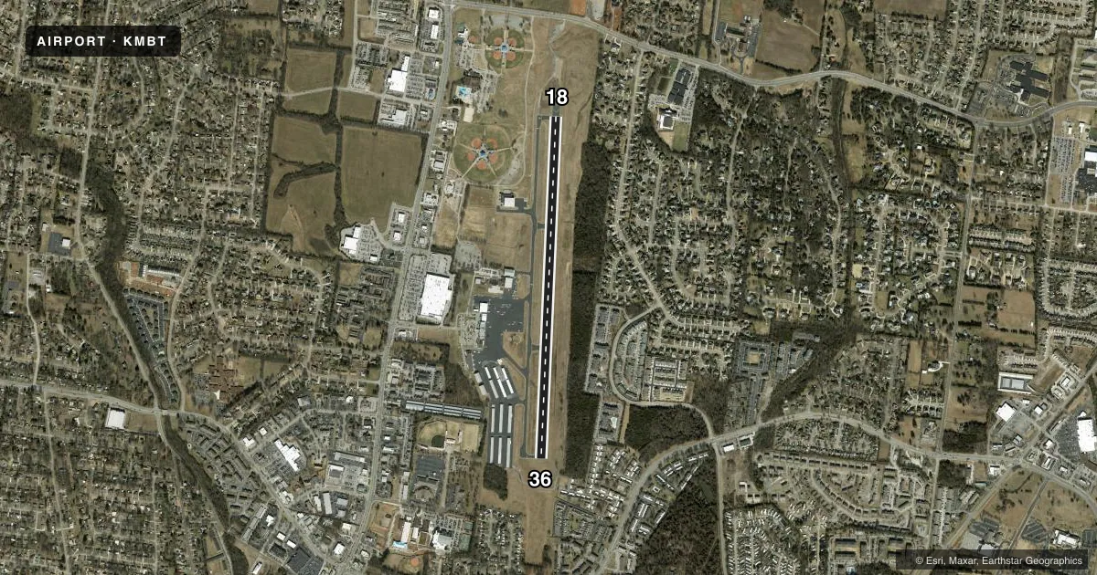
Airport sketch
Runways drawn to scale from FAA survey coordinates, rendered over satellite imagery. Not for navigation.
Approaches & charts
Services on the field
Fuel grades, oxygen, maintenance, ramp storage and lighting — as declared to the FAA by the airport operator.
Fuel & services
- Fuel
- 100LLA+
- Oxygen (bottled)
- Low pressure
- Oxygen (bulk)
- Low pressure
- Airframe repair
- Major
- Power plant repair
- Major
- Other services
- AFRT,AVNCS,CHTR,INSTR,RNTL,SALES
Ramp & ground
- Transient storage
- Tie-down
- Hangar
- Landing fee
- No fee published
- Customs
- Not available
- Lighting schedule
- SS-SR
- Beacon schedule
- SS-SR
- Beacon
- White / Green (civil land)(WG)
- Wind indicator
- Lighted
- Segmented circle
- Yes
Fuel & FBOs
Cheapest 100LL and Jet A on the field and nearby. Always confirm with the FBO before taxi.
Airport notes
Surface conditions, obstructions, local procedures, lighting outages and other notes published with each FAA cycle.
General notes
- STUDENT FLT TRNG 0800-1700.
- GCO AVBL ON FREQ 135.075 THRU NASHVILLE CD. IF UNA FOR CD CTC NASHVILLE APCH 615-695-4522.
- WILDLIFE INVOF ARPT.
- ENGINE RUN-UP CONDUCTED E SIDE OF MAIN RAMP.
- TRNG PAT CLSD 2200-0700 MON-FRI; WKEND & HOL 2200-0800; OTR TIMES PPR - AMGR.
- NOISE ABATEMENT PROC IN EFCT; DEP CMB 2000 FT MSL BFR TURN.
- OPDT PRACTICE APCHS NA.
Approach & departure obstructions
- 36CALM WIND RWY.
Other notes
- 3GEN ARPT INFO - 615-848-3254; EMERG OR AFT HR SVC - AMGR.
VFR map & nearby airports
VFR sectional. Tap any ICAO chip to open that airport.
Key facts · KMBT
Answer card- ICAO
- KMBT
- Name
- MURFREESBORO MUNI
- Location
- MURFREESBORO, TENNESSEE
- Elevation
- 614.2 ft MSL
- Traffic pattern altitude
- 1,614.2 ft MSL (1,000 AGL)
- Control tower
- Non-towered (use CTAF)
- Total runways
- 1
- Longest runway
- 18/36 · 4,750 ft
- Published ILS approaches
- 0
- Published frequencies
- 4
- Magnetic variation
- 2°
- Current flight rules
- VFR
- Current wind
- 180° at 6 kt
- Favored runway now
- RWY 18
Murfreesboro Muni sits in Murfreesboro, Tennessee. Field elevation is 614.2 ft MSL. The airport has one runway, 18/36, which is 4,750 ft long and asphalt. There is no control tower. No ILS approaches are published here. The pattern altitude is not published, so use the standard 1,000 ft AGL for light piston operations unless the current Chart Supplement says otherwise.
The on-field FBO is Murfreesboro Municipal Airport. It carries AVGAS 100LL and Jet A. Call the FBO directly at (615) 494-1900 for current service details before you go. Noise abatement is in effect. Departures climb to 2,000 ft MSL before turning. Runway 36 is the calm wind runway. Training patterns are closed from 2200 to 0700 Monday through Friday. They are closed from 2200 to 0800 on weekends and holidays. Other pattern use needs prior permission from the airport manager.
This is a training-active field with wildlife reported in the area. Engine run-up is on the east side of the main ramp. If you need clearance delivery help, the airport has a ground communications outlet on 135.075 through Nashville clearance delivery. For current procedures, check the current FAA Chart Supplement or call the airport manager before arrival.