METAR & TAF KMQY
Current METAR
Observed 13:12Z
KMQY 271312Z 10005KT 10SM BKN006 23/ A2995 RMK AO2 PNO $
- Wind
- 100° @ 5 kt
- Visibility
- 10 SM
- Temp / Dew
- —
- Altimeter
- 29.95 inHg
- Clouds
- BKN
- Density alt
- —
- Ceiling
- 600 ft AGL
- Rules
- IFR
Airport info & contacts
Manager on record, flight service, ARTCC, attendance schedule and pattern altitude — published by the FAA and refreshed every 28 days.
Location
- From city
- 2 NM N
- VFR sectional
- ATLANTA
- Pattern altitude
- 957 ft AGL · 1,500 ft MSL
- ARTCC
- ZME · MEMPHIS
- NOTAM facility
- MQY (NOTAM-D)
Airport manager
- Name
- EVAN LESTER
- Phone
- 615-459-2651
- Address
- 278 DOUG WARPOOLE RD., SMYRNA TN 37167
Flight service · Hours
- FSS BNA
- NASHVILLE1-800-WX-BRIEF
- Attendance
- ALL
Frequencies
Tap any row to copy the frequency to your clipboard.
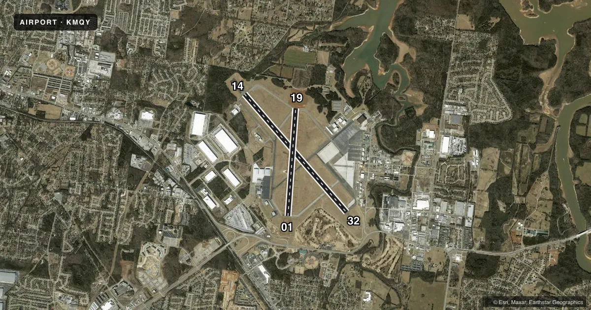
Runways & pattern
Full pagePattern entry · RWY 14
LEFT TRAFFIC| Runway | Heading (°M) | Length | Surface | Traffic |
|---|---|---|---|---|
| 14/32Favored | 137° / 317° | 8,038 ft | ASPH | Standard L |
| 01/19 | 2° / 182° | 5,546 ft | ASPH | Standard L |
Runway end performance
| End | TORA | TODA | ASDA | LDA | VGSI | Approach lights | Obstruction |
|---|---|---|---|---|---|---|---|
| 14 | — | — | — | — | PAPI 4-box left(3°) | — | 35', tree, 1500' from thr, 485' R of cntrln, slope 37 |
| 32 | — | — | — | — | PAPI 4-box left(3°) | MALSR | — |
| 01 | — | — | — | — | PAPI 4-box left(3.5°) | — | 74', tree, 1800' from thr, 143' R of cntrln, slope 21 |
| 19 | — | — | — | — | PAPI 4-box left(3°) | — | — |
Declared distances in feet. TORA = takeoff run available, TODA = takeoff distance, ASDA = accelerate-stop, LDA = landing distance.
Airport sketch
Runways drawn to scale from FAA survey coordinates, rendered over satellite imagery. Not for navigation.
Approaches & charts
ILS · 1
Services on the field
Fuel grades, oxygen, maintenance, ramp storage and lighting — as declared to the FAA by the airport operator.
Fuel & services
- Fuel
- 100LLA
- Oxygen (bottled)
- Low pressure
- Oxygen (bulk)
- HIGH/LOW
- Airframe repair
- Major
- Power plant repair
- Major
- Other services
- AMB,AVNCS,CHTR,INSTR,RNTL,SALES
Ramp & ground
- Transient storage
- Tie-down
- Hangar
- Landing fee
- No fee published
- Customs
- Not available
- Lighting schedule
- SEE RMK
- Beacon schedule
- SS-SR
- Beacon
- White / Green (civil land)(WG)
- Wind indicator
- Lighted
- Segmented circle
- Yes
Fuel & FBOs
Cheapest 100LL and Jet A on the field and nearby. Always confirm with the FBO before taxi.
Airport notes
Surface conditions, obstructions, local procedures, lighting outages and other notes published with each FAA cycle.
General notes
- TWY K LTD TO 65000 LB.
- NASHVILLE INTL TFC TRANSITS SMYRNA TFC AREA AT 2500 FT MSL & ABV.
- ANG BASE OPS 0630-1600 MON-FRI; PPR - D683-3611.
- 24 HR PPR OVR 30 PAX - AMGR.
- TWY J SOUTH OF TWY A LTD TO 65000 LB.
- CLASS D SVC 1300-0400Z MON-FRI.
- FOR CD WHEN ATCT CLSD, CTC NASHVILLE APCH AT 615-695-4522.
Lighting notes
- ACTVT MALSR RWY 32; REIL RWY 14; MIRL RWY 01/19; HIRL RWY 14/32 - CTAF. PAPI RWY 01, 14, 19 & 32 OPR CONSLY.
Fuel notes
- AC615-220-2957 OR C615-459-3337.
Runway surface & condition
- H1CLSD INDEFLY.
- H1OTS INDEFLY. MIL: ACTVT HELI PERIMETER LGT - AMGR.
Other notes
- TPA: 457 FT AGL HEL, 957 FT AGL LIGHT ACFT, 1457 FT AGL TURBOPROP/JET.
VFR map & nearby airports
VFR sectional. Tap any ICAO chip to open that airport.
Key facts · KMQY
Answer card- ICAO
- KMQY
- Name
- SMYRNA
- Location
- SMYRNA, TENNESSEE
- Elevation
- 543 ft MSL
- Traffic pattern altitude
- 1,500 ft MSL (957 AGL)
- Control tower
- Towered · 0700-2200 MON-FRI, 0700-1900 SAT-SUN
- Total runways
- 2
- Longest runway
- 14/32 · 8,038 ft
- Published ILS approaches
- 1
- Published frequencies
- 8
- Magnetic variation
- 2°
- Current flight rules
- IFR
- Current wind
- 100° at 5 kt
- Favored runway now
- RWY 14
KMQY is in Smyrna, Tennessee, about 20 miles southeast of Nashville. Field elevation is 543 ft MSL. The airport has two asphalt runways. The longest is 14/32 at 8,038 ft. Tower service runs 0700-2200 Monday through Friday. Weekend tower hours are 0700-1900. The field has one ILS approach. It is for runway 32.
Pattern altitude is 957 ft AGL for light aircraft. That is 1,500 ft MSL. Helicopters use 457 ft AGL. Turboprops and jets use 1,457 ft AGL. Nashville traffic transits the Smyrna traffic area at 2,500 ft MSL and above. That matters when you are setting up your arrival and scanning for traffic.
Hollingshead Aviation is on the field. It carries 100LL, Jet A and Jet A Prist. Azure Flight Support is also on the field. It carries 100LL and Jet A Prist. Call either FBO directly for current fuel and services. Published remarks also note that runway 01/19 is not available for certain large passenger operations. Taxiway J south of taxiway A is limited to 65,000 pounds. Taxiway K is also limited to 65,000 pounds. If you are arriving after tower hours, use the published clearance delivery procedure with BNA Approach on 121.7. The airport has Class D service from 1300 to 0400 Zulu Monday through Friday.