METAR & TAF KJWN
Current METAR
Observed 00:50Z
KJWN 270050Z 00000KT 10SM CLR 30/28 A2989
- Wind
- 000° @ 0 kt
- Visibility
- 10 SM
- Temp / Dew
- 30°C / 28°C
- Altimeter
- 29.89 inHg
- Clouds
- CLR
- Density alt
- 2,458 ft
- Ceiling
- Unlimited
- Rules
- VFR
Airport info & contacts
Manager on record, flight service, ARTCC, attendance schedule and pattern altitude — published by the FAA and refreshed every 28 days.
Location
- From city
- 1 NM NW
- VFR sectional
- ST LOUIS
- ARTCC
- ZME · MEMPHIS
- NOTAM facility
- BNA (NOTAM-D)
Airport manager
- Name
- ADAM C. WOLF
- Phone
- 615-275-1783
- Address
- 1000 TUNE AIRPORT DRIVE, NASHVILLE TN 37209
Flight service · Hours
- FSS BNA
- NASHVILLE1-800-WX-BRIEF
- Attendance
- ALL
Frequencies
Tap any row to copy the frequency to your clipboard.
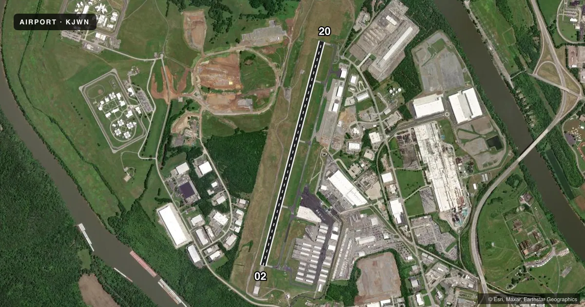
Runways & pattern
Full pagePattern entry · RWY 02
LEFT TRAFFICRunway end performance
| End | TORA | TODA | ASDA | LDA | VGSI | Approach lights | Obstruction |
|---|---|---|---|---|---|---|---|
| 02 | 6,001' | 6,001' | 6,001' | 6,001' | PAPI 4-box left(3°) | — | 80', tree, 2148' from thr, 112' R of cntrln, slope 24 |
| 20 | 6,001' | 6,001' | 6,001' | 6,001' | PAPI 4-box left(3°) | — | 40', tree, 1572' from thr, 397' R of cntrln, slope 34 |
Declared distances in feet. TORA = takeoff run available, TODA = takeoff distance, ASDA = accelerate-stop, LDA = landing distance.
Airport sketch
Runways drawn to scale from FAA survey coordinates, rendered over satellite imagery. Not for navigation.
Approaches & charts
ILS · 1
Services on the field
Fuel grades, oxygen, maintenance, ramp storage and lighting — as declared to the FAA by the airport operator.
Fuel & services
- Fuel
- 100LLA+
- Oxygen (bottled)
- High pressure
- Oxygen (bulk)
- Low pressure
- Airframe repair
- Major
- Power plant repair
- Major
- Other services
- AVNCS,CHTR,INSTR,RNTL,SALES
Ramp & ground
- Transient storage
- Tie-down
- Hangar
- Lighting schedule
- SEE RMK
- Beacon schedule
- SS-SR
- Beacon
- White / Green (civil land)(WG)
- Wind indicator
- Lighted
- Segmented circle
- Yes
Fuel & FBOs
Cheapest 100LL and Jet A on the field and nearby. Always confirm with the FBO before taxi.
Airport notes
Surface conditions, obstructions, local procedures, lighting outages and other notes published with each FAA cycle.
General notes
- BIRDS & DEER INVOF ARPT.
- BLEEDOVER OCR ALL FREQS 1.75 NM NORTH OF RWY.
- WHEN ATCT CLSD FOR CD CTC NASHVILLE APCH ON 124.55, IF UNABLE CALL 615-695-4524.
- TWY R1 CLSD TO ACFT WINGSPAN MORE THAN 49FT
- TWY R2 CLSD TO ACFT WINGSPAN MORE THAN 79FT
- CTC FBO 122.85
Lighting notes
- WHEN ATCT CLSD ACTVT REIL RWY 02 & 20; PAPI RWY 02 & 20; MIRL RWY 02/20 - CTAF.
Arresting gear
- 20_EMASENGINEERED MATERIAL ARRESTING SYSTEM (EMAS) 186 FT LONG BY 121 FT WIDE LCTD 560 FT FM DEP END RWY 20.
Other notes
- INSTRHEL & FIXED WING.
VFR map & nearby airports
VFR sectional. Tap any ICAO chip to open that airport.
Key facts · KJWN
Answer card- ICAO
- KJWN
- Name
- JOHN C TUNE
- Location
- NASHVILLE, TENNESSEE
- Elevation
- 501 ft MSL
- Traffic pattern altitude
- 1,501 ft MSL (1,000 AGL)
- Control tower
- Towered · 0700-2100
- Total runways
- 1
- Longest runway
- 02/20 · 6,001 ft
- Published ILS approaches
- 1
- Published frequencies
- 8
- Magnetic variation
- 3°
- Current flight rules
- VFR
- Current wind
- 000° at 0 kt
- Favored runway now
- –
John C Tune is in Nashville, Tennessee. The field elevation is 501 ft MSL. It has one runway, 02/20, which is 6,001 ft long. The airport is towered from 0700 to 2100. Runway 20 has an ILS. Pattern altitude is not published. Use 1,000 ft AGL for light piston traffic unless ATC gives you something different.
Contour is on the field. It carries 100LL and Jet A. Call 615-350-5000 for current service details before you go. The published remarks also note bleedover north of the runway. Expect that on the radios. Birds and deer are reported in the area too. Taxiway R1 is closed to aircraft with a wingspan over 49 feet. Taxiway R2 is closed to aircraft with a wingspan over 79 feet.
When the tower is closed, contact Nashville Approach on 124.55 for clearance delivery. If that does not work, the published phone number is 615-695-4524. Tower-closed lighting is available for the runway ends, the PAPI and the medium intensity runway lights on 02/20 through CTAF. This is a busy Nashville-area field. Keep your scan tight and be ready for frequency congestion near the airport.