METAR & TAF KMRC
Current METAR
Observed 13:10Z
KMRC 271310Z AUTO 04011G19KT 10SM FEW010 23/23 A2990 RMK A01
- Wind
- 040° @ 11G19 kt
- Visibility
- 10 SM
- Temp / Dew
- 23°C / 23°C
- Altimeter
- 29.90 inHg
- Clouds
- FEW
- Density alt
- 1,830 ft
- Ceiling
- Unlimited
- Rules
- VFR
Airport info & contacts
Manager on record, flight service, ARTCC, attendance schedule and pattern altitude — published by the FAA and refreshed every 28 days.
Location
- From city
- 2 NM NE
- VFR sectional
- ATLANTA
- ARTCC
- ZME · MEMPHIS
- NOTAM facility
- MKL (NOTAM-D)
Airport manager
- Name
- ASHLEY SCHANG
- Phone
- 931-379-5511
- Address
- 1200 NORTH MAIN ST, MT PLEASANT TN 38474
Flight service · Hours
- FSS MKL
- JACKSON1-800-WX-BRIEF
- Attendance
- 0700-1700
Frequencies
Tap any row to copy the frequency to your clipboard.
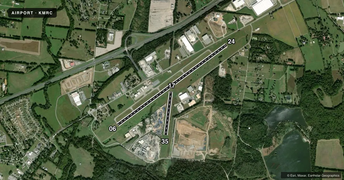
Runways & pattern
Full pagePattern entry · RWY 06
LEFT TRAFFIC| Runway | Heading (°M) | Length | Surface | Traffic |
|---|---|---|---|---|
| 06/24Favored | 53° / 233° | 6,000 ft | ASPH | Standard L |
| 17/35 | 186° / 6° | 1,941 ft | TURF | Standard L |
Runway end performance
| End | TORA | TODA | ASDA | LDA | VGSI | Approach lights | Obstruction |
|---|---|---|---|---|---|---|---|
| 06 | 6,000' | 6,000' | 6,000' | 6,000' | PAPI 4-box right(3°) | — | 49', tree, 1296' from thr, 206' R of cntrln, slope 22 |
| 24 | 6,000' | 6,000' | 6,000' | 6,000' | PAPI 4-box left(3°) | ODALS | 52', tree, 1270' from thr, 348' R of cntrln, slope 20 |
| 17 | — | — | — | — | — | — | 81', pole, 1379' from thr, 194' R of cntrln, slope 17 |
Declared distances in feet. TORA = takeoff run available, TODA = takeoff distance, ASDA = accelerate-stop, LDA = landing distance.
Airport sketch
Runways drawn to scale from FAA survey coordinates, rendered over satellite imagery. Not for navigation.
Approaches & charts
Services on the field
Fuel grades, oxygen, maintenance, ramp storage and lighting — as declared to the FAA by the airport operator.
Fuel & services
- Fuel
- 100LLA+
- Airframe repair
- Minor
- Power plant repair
- Minor
- Other services
- AMB,AVNCS,INSTR,RNTL
Ramp & ground
- Transient storage
- Tie-down
- Hangar
- Landing fee
- No fee published
- Customs
- Not available
- Lighting schedule
- SEE RMK
- Beacon schedule
- SS-SR
- Beacon
- White / Green (civil land)(WG)
- Wind indicator
- Lighted
- Segmented circle
- Yes
Fuel & FBOs
Cheapest 100LL and Jet A on the field and nearby. Always confirm with the FBO before taxi.
Airport notes
Surface conditions, obstructions, local procedures, lighting outages and other notes published with each FAA cycle.
General notes
- 330 FT LGTD ANT 1.9 NM SW.
- FOR CD CTC MEMPHIS ARTCC AT 901-368-8453/8449.
Lighting notes
- ACTVT ODALS RWY 24; REIL RWY 24 - CTAF.
Other notes
- 1CLSD THANKSGIVING & CHRISTMAS.
VFR map & nearby airports
VFR sectional. Tap any ICAO chip to open that airport.
Key facts · KMRC
Answer card- ICAO
- KMRC
- Name
- MAURY COUNTY RGNL
- Location
- COLUMBIA/MOUNT PLEASANT, TENNESSEE
- Elevation
- 681.3 ft MSL
- Traffic pattern altitude
- 1,681.3 ft MSL (1,000 AGL)
- Control tower
- Non-towered (use CTAF)
- Total runways
- 2
- Longest runway
- 06/24 · 6,000 ft
- Published ILS approaches
- 0
- Published frequencies
- 2
- Magnetic variation
- 1°
- Current flight rules
- VFR
- Current wind
- 040° at 11 kt
- Favored runway now
- RWY 06
Maury County Rgnl sits in Columbia and Mount Pleasant, Tennessee. Field elevation is 681.3 ft MSL. The airport has two runways. The longest is 6,000 ft asphalt runway 06/24. There is also a 1,941 ft turf runway 17/35. The field is non-towered. CTAF and UNICOM are both 122.8.
Runway 24 has the published ILS approach. The runway also has runway end identifier lights. The approach lighting system for runway 24 is omnidirectional. A 330-foot lighted antenna sits 1.9 NM southwest of the field. Keep that in mind on arrival and departure planning. Pattern altitude is not published in the facts. For light piston traffic, use 1,000 ft AGL unless the current Chart Supplement says otherwise. That puts the pattern at about 1,681 ft MSL based on the field elevation.
Maury County Regional Airport is the on-field FBO. It carries 100LL, Jet A and Jet A Prist. The airport is closed on Thanksgiving and Christmas. For clearance delivery, contact Memphis ARTCC. If you are planning a night or IFR arrival, runway 24 is the one with the published instrument support.