METAR & TAF 0M3
0M3 does not publish a METAR.
Showing the nearest reporting station: KMRC (MAURY COUNTY RGNL) · 20.4 NM away. Conditions at 0M3 may differ.
METAR · KMRC
Observed 12:50Z
KMRC 271250Z AUTO 20010KT 9SM CLR 23/23 A2985 RMK A01
- Wind
- 200° @ 10 kt
- Visibility
- 9 SM
- Temp / Dew
- 23°C / 23°C
- Altimeter
- 29.85 inHg
- Clouds
- CLR
- Density alt
- 2,252 ft
- Ceiling
- Unlimited
- Rules
- VFR
Airport info & contacts
Manager on record, flight service, ARTCC, attendance schedule and pattern altitude — published by the FAA and refreshed every 28 days.
Location
- From city
- 2 NM W
- VFR sectional
- ATLANTA
- ARTCC
- ZME · MEMPHIS
- NOTAM facility
- MKL (NOTAM-D)
Airport manager
- Name
- GARY NASH
- Phone
- 931-796-3448
- Address
- 1180 W MAIN ST, HOHENWALD TN 38462
Flight service · Hours
- FSS MKL
- JACKSON1-800-WX-BRIEF
- Attendance
- Unattended
Frequencies
Tap any row to copy the frequency to your clipboard.
Runways & pattern
Full pagePattern entry · RWY 20
LEFT TRAFFICRunway end performance
| End | TORA | TODA | ASDA | LDA | VGSI | Approach lights | Obstruction |
|---|---|---|---|---|---|---|---|
| 02 | — | — | — | — | PAPI 2-box left(3°) | — | 78', trees, 1620' from thr, 358' R of cntrln, slope 18 |
| 20 | — | — | — | — | PAPI 2-box left(3°) | — | 70', trees, 938' from thr, 74' R of cntrln, slope 10 |
Declared distances in feet. TORA = takeoff run available, TODA = takeoff distance, ASDA = accelerate-stop, LDA = landing distance.
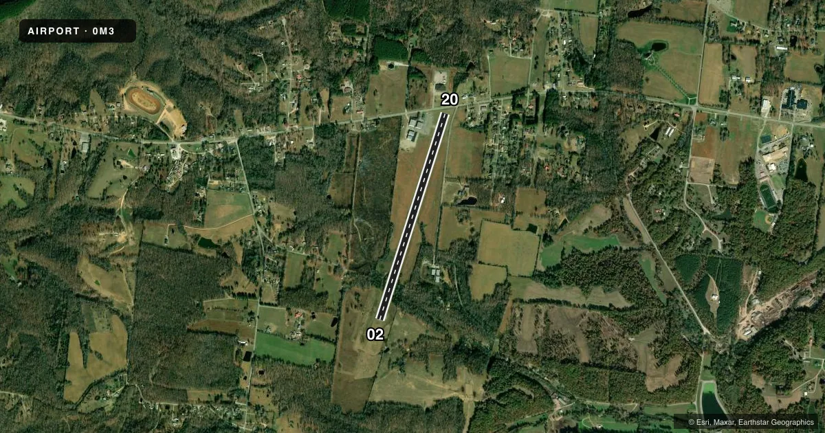
Airport sketch
Runways drawn to scale from FAA survey coordinates, rendered over satellite imagery. Not for navigation.
Approaches & charts
Services on the field
Fuel grades, oxygen, maintenance, ramp storage and lighting — as declared to the FAA by the airport operator.
Fuel & services
- Fuel
- 100LL
- Other services
- INSTR
Ramp & ground
- Transient storage
- Tie-down
- Landing fee
- No fee published
- Customs
- Not available
- Lighting schedule
- SEE RMK
- Beacon schedule
- SS-SR
- Beacon
- White / Green (civil land)(WG)
- Wind indicator
- Lighted
- Segmented circle
- No
Fuel & FBOs
Cheapest 100LL and Jet A on the field and nearby. Always confirm with the FBO before taxi.
Airport notes
Surface conditions, obstructions, local procedures, lighting outages and other notes published with each FAA cycle.
General notes
- FOR CD CTC MEMPHIS ARTCC AT 901-368-8453/8449.
Lighting notes
- ACTVT MIRL RWY 02/20 - CTAF. REIL RWY 02 & 20; PAPI RWY 02 & 20 OPR CONSLY.
Fuel notes
- 100LLFUEL AVBL 24/7 WITH CC.
Approach & departure obstructions
- 02FADED AND PEELING.
- 20FADED AND PEELING.
- 20APCH RATIO 20:1 TO DTHR.
VFR map & nearby airports
VFR sectional. Tap any ICAO chip to open that airport.
Key facts · 0M3
Answer card- ICAO
- 0M3
- Name
- PAUL BRIDGES FLD
- Location
- HOHENWALD, TENNESSEE
- Elevation
- 972 ft MSL
- Traffic pattern altitude
- 1,972 ft MSL (1,000 AGL)
- Control tower
- Non-towered (use CTAF)
- Total runways
- 1
- Longest runway
- 02/20 · 4,001 ft
- Published ILS approaches
- 0
- Published frequencies
- 2
- Magnetic variation
- 1°
- Current flight rules
- VFR
- Current wind
- 200° at 10 kt
- Favored runway now
- RWY 20
Paul Bridges Fld sits in Hohenwald, Tennessee. The field elevation is 972 ft MSL. It has one runway, 02/20, which is 4,001 ft long and paved with asphalt. The airport is non-towered. CTAF and UNICOM are both 122.8. No ILS approaches are published here.
The pattern altitude is not published. Use the standard 1,000 ft AGL pattern unless the current Chart Supplement says otherwise. That puts the light piston pattern at 1,972 ft MSL based on the field elevation. The runway lighting is pilot-activated on CTAF. Runway end identifier lights are installed on both ends. Precision approach path indicators operate continuously on runway 02 and runway 20. Runway markings on both ends are faded and peeling, so brief yourself to expect worn paint on final and in the flare.
Paul Bridges Field is the on-field FBO. It carries 100LL. Fuel is available 24 hours a day, 7 days a week with credit card. For IFR clearance delivery, Memphis ARTCC is the published contact. The runway 20 approach has a 20:1 slope to the displaced threshold, so watch your descent profile and verify the threshold picture before you commit. Check the current Chart Supplement for any other local notes before arrival.