METAR & TAF KGHM
KGHM does not publish a METAR.
Showing the nearest reporting station: KMRC (MAURY COUNTY RGNL) · 21.4 NM away. Conditions at KGHM may differ.
METAR · KMRC
Observed 17:50Z
KMRC 261750Z AUTO 00000KT 9SM BKN018 31/27 A2998 RMK A01
- Wind
- 000° @ 0 kt
- Visibility
- 9 SM
- Temp / Dew
- 31°C / 27°C
- Altimeter
- 29.98 inHg
- Clouds
- BKN
- Density alt
- 2,794 ft
- Ceiling
- 1,800 ft AGL
- Rules
- MVFR
Airport info & contacts
Manager on record, flight service, ARTCC, attendance schedule and pattern altitude — published by the FAA and refreshed every 28 days.
Location
- From city
- 3 NM N
- VFR sectional
- ATLANTA
- ARTCC
- ZME · MEMPHIS
- NOTAM facility
- MKL (NOTAM-D)
Airport manager
- Name
- WOODY WOODRUFF
- Phone
- 931-729-3032
- Address
- 2650 AIRPORT RD, CENTERVILLE TN 37033
Flight service · Hours
- FSS MKL
- JACKSON1-800-WX-BRIEF
- Attendance
- MON-FRI · 0730-1600
Frequencies
Tap any row to copy the frequency to your clipboard.
Runways & pattern
Full pagePattern entry · RWY 02
LEFT TRAFFICRunway end performance
| End | TORA | TODA | ASDA | LDA | VGSI | Approach lights | Obstruction |
|---|---|---|---|---|---|---|---|
| 02 | — | — | — | — | PAPI 4-box left(4°) | — | 71', trees, 999' from thr, 256' R of cntrln, slope 11 |
| 20 | — | — | — | — | PAPI 4-box left(4°) | — | 60', tree, 862' from thr, 208' R of cntrln, slope 11 |
Declared distances in feet. TORA = takeoff run available, TODA = takeoff distance, ASDA = accelerate-stop, LDA = landing distance.
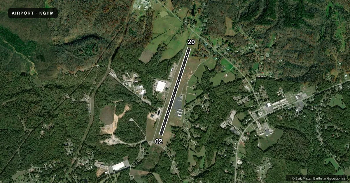
Airport sketch
Runways drawn to scale from FAA survey coordinates, rendered over satellite imagery. Not for navigation.
Approaches & charts
Services on the field
Fuel grades, oxygen, maintenance, ramp storage and lighting — as declared to the FAA by the airport operator.
Fuel & services
- Fuel
- 100LLA+
Ramp & ground
- Transient storage
- Tie-down
- Hangar
- Landing fee
- No fee published
- Customs
- Not available
- Lighting schedule
- SEE RMK
- Beacon schedule
- SS-SR
- Beacon
- White / Green (civil land)(WG)
- Wind indicator
- Lighted
- Segmented circle
- Yes
Fuel & FBOs
Cheapest 100LL and Jet A on the field and nearby. Always confirm with the FBO before taxi.
Airport notes
Surface conditions, obstructions, local procedures, lighting outages and other notes published with each FAA cycle.
General notes
- FOR CD CTC NASHVILLE APCH AT 615-695-4524.
Lighting notes
- MIRL RWY 02/20 OPR DUSK-DAWN & PRESET LOW INTST; INCR INTST & ACTVT - CTAF. 0730-1600 ACTVT VGSI RWY 02 - CTAF.
Fuel notes
- 100LLFUEL AVBL H24 WITH CREDIT CARD.
Approach & departure obstructions
- 20PAPI UNUSBL BYD 5 DEGS LEFT OF CNTRLN.
Other notes
- 2AFT HR - 615-418-2164.
VFR map & nearby airports
VFR sectional. Tap any ICAO chip to open that airport.
Key facts · KGHM
Answer card- ICAO
- KGHM
- Name
- CENTERVILLE MUNI
- Location
- CENTERVILLE, TENNESSEE
- Elevation
- 765 ft MSL
- Traffic pattern altitude
- 1,765 ft MSL (1,000 AGL)
- Control tower
- Non-towered (use CTAF)
- Total runways
- 1
- Longest runway
- 02/20 · 4,002 ft
- Published ILS approaches
- 0
- Published frequencies
- 4
- Magnetic variation
- 3°
- Current flight rules
- MVFR
- Current wind
- 000° at 0 kt
- Favored runway now
- –
Centerville Muni sits in Centerville, Tennessee. Field elevation is 765 ft MSL. The airport has one runway. Runway 02/20 is 4,002 ft of asphalt, so it works for light piston traffic and some larger aircraft with proper performance planning. There is no control tower. CTAF and UNICOM are both 122.8. Nashville Approach handles approach and departure services on 119.35 and 372.0. No ILS approaches are published here.
Pattern altitude is not published. Use the standard 1,000 ft AGL for light piston traffic unless the current Chart Supplement says otherwise. The field has 24-hour self-serve 100LL with credit card. Centerville Municipal Airport is the on-field FBO. It carries 100LL and Jet A. Call (931) 729-3032 for current service details. After hours contact is 615-418-2164.
Runway lighting is medium intensity on 02/20. It runs from dusk to dawn at preset low intensity. You can increase intensity and activate the lights on CTAF. From 0730 to 1600, the visual glide slope indicators on runway 02 are activated on CTAF. One operational item to watch is the PAPI on runway 20. It is unusable beyond 5 degrees left of centerline. If you need a clearance, Nashville Approach handles clearance delivery at 615-695-4524. Check the current Chart Supplement for any noise or curfew restrictions before flying in.