METAR & TAF M15
M15 does not publish a METAR.
Showing the nearest reporting station: KPVE (BEECH RIVER RGNL) · 16.0 NM away. Conditions at M15 may differ.
METAR · KPVE
Observed 06:55Z
KPVE 270655Z AUTO 00000KT 10SM FEW030 FEW036 23/23 A2992 RMK A01
- Wind
- 000° @ 0 kt
- Visibility
- 10 SM
- Temp / Dew
- 23°C / 23°C
- Altimeter
- 29.92 inHg
- Clouds
- FEW
- Density alt
- 1,878 ft
- Ceiling
- Unlimited
- Rules
- VFR
Airport info & contacts
Manager on record, flight service, ARTCC, attendance schedule and pattern altitude — published by the FAA and refreshed every 28 days.
Location
- From city
- 3 NM SW
- VFR sectional
- ATLANTA
- ARTCC
- ZME · MEMPHIS
- NOTAM facility
- MKL (NOTAM-D)
Airport manager
- Name
- BOB OUSLEY
- Phone
- (615) 513-5852
- Address
- COUNTY COURTHOUSE, P.O. BOX 16, LINDEN TN 37096
Flight service · Hours
- FSS MKL
- JACKSON1-800-WX-BRIEF
- Attendance
- Unattended
Frequencies
Tap any row to copy the frequency to your clipboard.
Runways & pattern
Full pagePattern entry · RWY 18
LEFT TRAFFICRunway end performance
| End | TORA | TODA | ASDA | LDA | VGSI | Approach lights | Obstruction |
|---|---|---|---|---|---|---|---|
| 18 | 3,600' | 3,600' | — | 3,460' | PAPI 2-box left | — | — |
| 36 | 3,600' | 3,600' | — | 3,483' | PAPI 2-box left | — | 21', trees, 207' from thr, 55' R of cntrln, slope 0 |
Declared distances in feet. TORA = takeoff run available, TODA = takeoff distance, ASDA = accelerate-stop, LDA = landing distance.
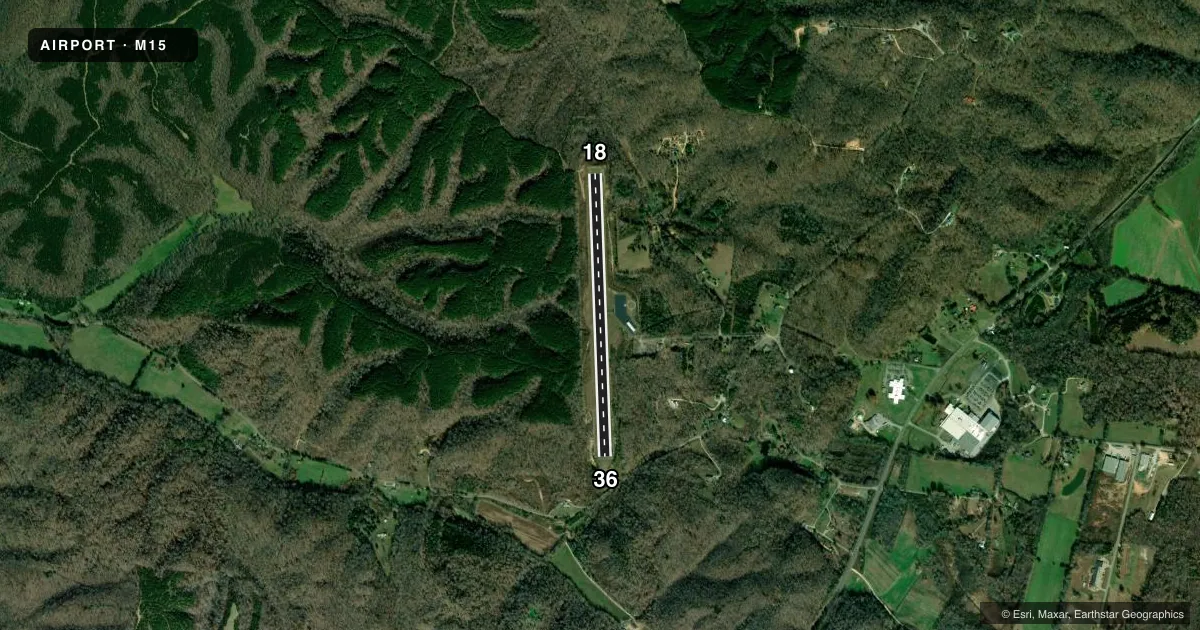
Airport sketch
Runways drawn to scale from FAA survey coordinates, rendered over satellite imagery. Not for navigation.
Approaches & charts
Services on the field
Fuel grades, oxygen, maintenance, ramp storage and lighting — as declared to the FAA by the airport operator.
Fuel & services
- Fuel
- Not available
- Oxygen (bottled)
- Not available
- Oxygen (bulk)
- Not available
- Airframe repair
- Not available
- Power plant repair
- Not available
Ramp & ground
- Transient storage
- Tie-down
- Landing fee
- No fee published
- Customs
- Not available
- Lighting schedule
- SS-SR
- Beacon schedule
- SS-SR
- Beacon
- White / Green (civil land)(WG)
- Wind indicator
- Lighted
- Segmented circle
- Yes
Fuel & FBOs
Cheapest 100LL and Jet A on the field and nearby. Always confirm with the FBO before taxi.
Airport notes
Surface conditions, obstructions, local procedures, lighting outages and other notes published with each FAA cycle.
General notes
- FOR CD CTC MEMPHIS ARTCC AT 901-368-8453/8449.
Approach & departure obstructions
- 18CTLG OBSTN EXCEEDS 45 DEG SLP.
Other notes
- MANAGERPHYSICAL AIRPORT ADDRESS IS 799 AIRPORT RD., LINDEN, TN 37096
VFR map & nearby airports
VFR sectional. Tap any ICAO chip to open that airport.
Key facts · M15
Answer card- ICAO
- M15
- Name
- JAMES TUCKER
- Location
- LINDEN, TENNESSEE
- Elevation
- 740 ft MSL
- Traffic pattern altitude
- 1,740 ft MSL (1,000 AGL)
- Control tower
- Non-towered (use CTAF)
- Total runways
- 1
- Longest runway
- 18/36 · 3,600 ft
- Published ILS approaches
- 0
- Published frequencies
- 1
- Magnetic variation
- 1°
- Current flight rules
- VFR
- Current wind
- 000° at 0 kt
- Favored runway now
- –
James Tucker Airport (M15) sits in Linden, Tennessee. The field elevation is 740 ft MSL. It has one runway. Runway 18/36 is 3,600 ft long with an asphalt surface. There is no control tower. CTAF is 122.9. No ILS approaches are published here.
The pattern altitude is not published. Use the standard 1,000 ft AGL unless the current Chart Supplement says otherwise. That puts the traffic pattern at 1,740 ft MSL based on the field elevation, but verify before you fly. The published remarks call out an obstruction near runway 18 that exceeds a 45 degree slope. Plan your arrival with that in mind, especially if you are coming in low or from the south. The airport also lists the physical address as 799 Airport Road, Linden, Tennessee 37096. For clearance delivery, Memphis ARTCC can be reached at 901-368-8453 or 901-368-8449. No on-field FBOs are listed, so contact the airport operator directly or call ahead for current services before arrival.